
Talk:New Jersey Route 64/GA1
GA Review[edit]
Article (edit | visual edit | history) · Article talk (edit | history) · Watch
Comments:
- In lead, do not use "then" when describing progression of route.
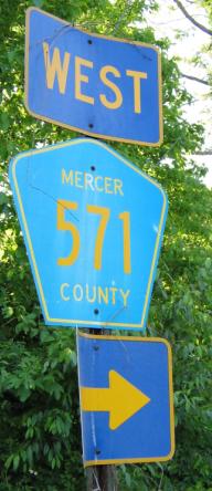
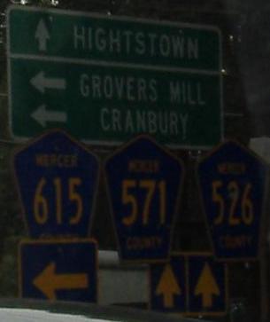
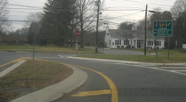
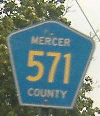
- "County Routes 526 and 571, which are unofficially concurrent with Route 64": according to the 571 SLD, the route is concurrent with 64, which means it would not be "unofficial". 526, on the other hand, is unofficial as the SLD does not show 526 following 571 to Princeton, contrary to signage.
- The sentence "It is not currently planned that Route 64 will receive an extension of sorts from the proposed Penns Neck Bypass to U.S. Route 1, a proposed realignment of County Routes 526 and 571." sounds awkward.
- The route description needs to be flipped as you describe it north to south.
- Do not use "then" in describing progression of route in route description.
- "Amtrak and New Jersey Transit-owned Northeast Corridor Line": only Amtrak owns the line. I would suggesting changing to "the Northeast Corridor Line used by Amtrak and New Jersey Transit".
- "The route was designated in 1938 from State Highway Route 31 in Princeton (where County Routes 526 and 527 currently meet)", this statement is definitely wrong as CR 527 comes nowhere near Princeton.
- The sentence "Although Route 571 and Route 526 are proposed to be realigned onto the new alignment, there is no designated change proposed for Route 64, although one state figure shows Route 64 running along Washington Road, where the two county routes currenly run." is wordy.
- The Major intersections table is wrong as NJ 64 is a north-south road according to the SLD.
- How are 13 and 162 related to 64 besides the fact they are just bridges?
I am placing the article on hold. Dough4872 (talk) 23:14, 1 September 2009 (UTC)
- The same exact thing as 64 (in terms of 13/162). Also, the route's east-west - something screwed up the infobox. Its viewed in the SLD and its viewed in the state law of 31A, which 64 uses part of. The rest are done. The 527 was stupid screwup as I meant to say 571.Mitch32(Want help? See here!) 23:26, 1 September 2009 (UTC)
- State disagrees with itself. Also, Route 1 to the east is shown on the north/south alignment on the SLD, therefore it has to be an East-West.Mitch32(Want help? See here!) 23:47, 1 September 2009 (UTC)
- I agree with Mitchazenia here. The SLD for NY 64 shows that the highway is only north-south for a short distance near its eastern terminus, but the majority of the road is east-west. –CG 23:54, 1 September 2009 (UTC)
- It doesn't matter what direction the highway runs, it matters what direction it is officially designated. So I stand with my position. Dough4872 (talk) 23:59, 1 September 2009 (UTC)
- The state law for 31A, which 64 used the alignment specifically mentioned East-West. The sld shows Route 1 heading north-south therefore, the route should we east-west.Mitch32(Want help? See here!) 00:18, 2 September 2009 (UTC)
- I think you should email NJDOT and see what they say the direction of NJ 64 is. Dough4872 (talk) 00:24, 2 September 2009 (UTC)
- Tried in the past. Not going to get a reply. And an e-mail cannot be used as a source.Mitch32(Want help? See here!) 00:25, 2 September 2009 (UTC)
- I don't know what to do at this point. I do not feel comfortable passing an article that possibly has the route in the wrong direction, and we cannot come to an agreement on whether it is N-S or E-W. Dough4872 (talk) 00:31, 2 September 2009 (UTC)
- The route is marked east-west on the SLDs! The route it follows is legislated east-west in 1938! The 2007 state map shows it east-west! The route drives east-west! What else do you need to know its east-west?Mitch32(Want help? See here!) 00:34, 2 September 2009 (UTC)
- An official current reliable source that says "east-west". Just because a map shows it in a east-west orientation does not mean it is designated as such. Dough4872 (talk) 00:36, 2 September 2009 (UTC)
- That doesn't make anything crap when the route isn't signed at all! You are also blatantly ignoring the legislation of Route 31A which marks it right there east-west! There's nothing on the SLD even mentioning direction! I will get pissed if I need to.Mitch32(Want help? See here!) 00:39, 2 September 2009 (UTC)
- No need to get upset, we'll take this discussion to WT:USRD to see what others think. Dough4872 (talk) 00:41, 2 September 2009 (UTC)
- No. You making this problem. The people who make the SLDs are the same people who make the state map, the NJ State Department of Transportation GIS! What the hell is the problem? The sources are going against this bullshit issue.Mitch32(Want help? See here!) 00:43, 2 September 2009 (UTC)
- Who knows, there may be an error in the SLD, but I still think we need consensus so I opened the discussion. It is not worth flipping out over, we'll get it worked out. Dough4872 (talk) 00:46, 2 September 2009 (UTC)
- I am pissed as hell. Route 1 doesn't go east-west in New Jersey. The route goes north-south in Jersey! Route 64 is east-west - and so is 571 in Mercer County - see this!Mitch32(Want help? See here!) 00:49, 2 September 2009 (UTC)
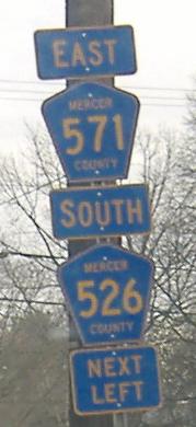
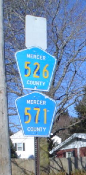
- The 571 SLD says it is a north-south road. However, I noticed a few pictures that in fact indicate it is signed east-west. 1]. But there are also pictures such as this one and this one that label 571 N-S. Who knows at this point. Dough4872 (talk) 00:56, 2 September 2009 (UTC)
- This involves a County Route! We're in Mercer County, therefore Mercer County signage applies.Mitch32(Want help? See here!) 01:00, 2 September 2009 (UTC)
- The 571 SLD says it is a north-south road. However, I noticed a few pictures that in fact indicate it is signed east-west. 1]. But there are also pictures such as this one and this one that label 571 N-S. Who knows at this point. Dough4872 (talk) 00:56, 2 September 2009 (UTC)
- I am pissed as hell. Route 1 doesn't go east-west in New Jersey. The route goes north-south in Jersey! Route 64 is east-west - and so is 571 in Mercer County - see this!Mitch32(Want help? See here!) 00:49, 2 September 2009 (UTC)
- Who knows, there may be an error in the SLD, but I still think we need consensus so I opened the discussion. It is not worth flipping out over, we'll get it worked out. Dough4872 (talk) 00:46, 2 September 2009 (UTC)
- No. You making this problem. The people who make the SLDs are the same people who make the state map, the NJ State Department of Transportation GIS! What the hell is the problem? The sources are going against this bullshit issue.Mitch32(Want help? See here!) 00:43, 2 September 2009 (UTC)
- No need to get upset, we'll take this discussion to WT:USRD to see what others think. Dough4872 (talk) 00:41, 2 September 2009 (UTC)
- That doesn't make anything crap when the route isn't signed at all! You are also blatantly ignoring the legislation of Route 31A which marks it right there east-west! There's nothing on the SLD even mentioning direction! I will get pissed if I need to.Mitch32(Want help? See here!) 00:39, 2 September 2009 (UTC)
- An official current reliable source that says "east-west". Just because a map shows it in a east-west orientation does not mean it is designated as such. Dough4872 (talk) 00:36, 2 September 2009 (UTC)
- The route is marked east-west on the SLDs! The route it follows is legislated east-west in 1938! The 2007 state map shows it east-west! The route drives east-west! What else do you need to know its east-west?Mitch32(Want help? See here!) 00:34, 2 September 2009 (UTC)
- I don't know what to do at this point. I do not feel comfortable passing an article that possibly has the route in the wrong direction, and we cannot come to an agreement on whether it is N-S or E-W. Dough4872 (talk) 00:31, 2 September 2009 (UTC)
- Tried in the past. Not going to get a reply. And an e-mail cannot be used as a source.Mitch32(Want help? See here!) 00:25, 2 September 2009 (UTC)
- I think you should email NJDOT and see what they say the direction of NJ 64 is. Dough4872 (talk) 00:24, 2 September 2009 (UTC)
- The state law for 31A, which 64 used the alignment specifically mentioned East-West. The sld shows Route 1 heading north-south therefore, the route should we east-west.Mitch32(Want help? See here!) 00:18, 2 September 2009 (UTC)
- It doesn't matter what direction the highway runs, it matters what direction it is officially designated. So I stand with my position. Dough4872 (talk) 23:59, 1 September 2009 (UTC)
- I agree with Mitchazenia here. The SLD for NY 64 shows that the highway is only north-south for a short distance near its eastern terminus, but the majority of the road is east-west. –CG 23:54, 1 September 2009 (UTC)
- State disagrees with itself. Also, Route 1 to the east is shown on the north/south alignment on the SLD, therefore it has to be an East-West.Mitch32(Want help? See here!) 23:47, 1 September 2009 (UTC)
- I think there needs to be another source that says it's N-S. Can you find one for us? --Fredddie™ 00:51, 2 September 2009 (UTC)
- So, should we say it is N-S now? Dough4872 (talk) 01:35, 2 September 2009 (UTC)
- I decided to take out directions entirely. We cannot agree and apparently the DOT and the Mercer County DPW are to blame. Will this be a little more rational?Mitch32(Want help? See here!) 01:42, 2 September 2009 (UTC)
My proposal[edit]
If the state apparently cannot agree on sources, I feel we should default to the next level of jurisdiction, which is Mercer County. Being Mercer County Route 571 (and possibly 526) head eastward through Mercer County and is signed like that in Mercer County, the default should apply.Mitch32(Want help? See here!) 01:06, 2 September 2009 (UTC)
Since the direction issue seems to be resolved, I will finally pass the article. Dough4872 (talk) 01:50, 2 September 2009 (UTC)