
Talk:Lake Constance
| This It is of interest to the following WikiProjects: | |||||||||||||||||||||||||||||||||||||||||||||||||||
| |||||||||||||||||||||||||||||||||||||||||||||||||||


| This article contains a translation of Bodensee from de.wikipedia. |
Wiki Education Foundation-supported course assignment[edit]
![]() This article was the subject of a Wiki Education Foundation-supported course assignment, between 23 August 2021 and 10 December 2021. Further details are available on the course page. Student editor(s): Marissarp. Peer reviewers: DanielleNabor, Sophie Bazan.
This article was the subject of a Wiki Education Foundation-supported course assignment, between 23 August 2021 and 10 December 2021. Further details are available on the course page. Student editor(s): Marissarp. Peer reviewers: DanielleNabor, Sophie Bazan.
Above undated message substituted from Template:Dashboard.wikiedu.org assignment by PrimeBOT (talk) 02:07, 17 January 2022 (UTC)
Schwäbisches Meer[edit]
Das sagen aber auch nur die Schwaben, in Bayern heißt der See auch bayrisches Meer. —The preceding unsigned comment was added by 84.57.208.106 (talk) 19:43, 9 January 2007 (UTC).
- Falsch, das bayrische Meer ist in Bayern der Chiemsee. —Preceding unsigned comment added by 04:33, 4 February 2007 (talk • contribs) 76.184.21.29
- folks, this is the ENGLISH wiki - so don't post so much German, please —Preceding unsigned comment added by 84.164.240.26 (talk) 19:06, 23 February 2008 (UTC)
- The two German-speaking contributors said, respectively, roughly:
- But only the Schwabians say that [i.e., Swabian See]; in Bavaria, that lake [Constance] is also called the "Bavarian Sea".
- Wrong, in Bavaria, the Bavarian See is the Chiemsee [i.e., in the context of what the preceding discussant said: "it's the Chiemsee that's called 'Bavarian Sea'."]
- But only the Schwabians say that [i.e., Swabian See]; in Bavaria, that lake [Constance] is also called the "Bavarian Sea".
I would cut the comment about the 'Swabian Sea' being illogical. First: it is a really big lake which is like a sea. Second: it isn't true that Swabians don't live beside it. They do. The area to the immediate north of the lake is 'Oberschwaben' (Upper Swabia). It is true that the southern edge is Swiss, and the western half of the northern shore has traditionally been part of Baden rather than of Swabia ('Württemberg'), but the eastern half of the northern shore has always been Swabian. I would guess that many in the western half would nowadays think of themselves as Swabians too. Vronks (talk) 15:11, 15 December 2010 (UTC)
"The lake is also colloquially known as the Swabian Sea[1] (das schwäbische Meer), which is somehow missleading since obviousely not a sea and there are no swabians living on the lake's shore." The latter part of this statement is false! They do live on the lake's shore, many of those beach bums! —Preceding unsigned comment added by 89.247.153.16 (talk) 04:35, 27 December 2010 (UTC)
translation[edit]
The German version seems to be quite a bit better. I am going to work on translating what I can of it to merge some of the useful stuff here.--66.153.117.118 (talk) 20:58, 13 April 2008 (UTC)
- Without knowing whose translation the current revision is, and with humility (the Germans who've praised my German clearly meant "good ... for an Ami", and have English much stronger than my German), i'm going to call the current version a bad translation -- probably bcz it's usually a lot harder to translate from your native language than to it. I'm not sure i'd really improve it if i tried to revise, but i think i'll try to get around to at least critiquing, here on the talk page, the awkward or confusing translations of specific phrases.
--Jerzy•t 00:05, 21 March 2009 (UTC)
error in surface area[edit]
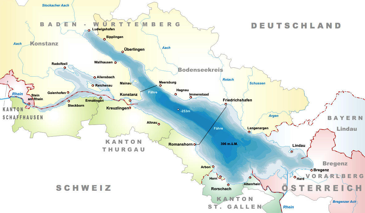
476 km² + 61 km² + 63 km² = 571 km²? Strange math!
According to http://www.bodenseekonferenz.org/21885/Service/DieRegion/index.aspx size is 473 km² (main) + 63 km² (Untersee) = 536 km². Überlinger See is only another name for the north-western part of the main lake. —Preceding unsigned comment added by 91.19.88.254 (talk) 09:36, 26 April 2008 (UTC)
it says: "The freshwater lake sits at 395 m above sea level and is Central Europe's third largest, after Lake Balaton and Lake Geneva."
well.. Lake Geneva is much smaller than Lake Constance .. so Lake Constanze should be the "SECOND largest .., followed by Lake Geneva" 79.234.83.74 (talk) 13:22, 22 March 2010 (UTC)
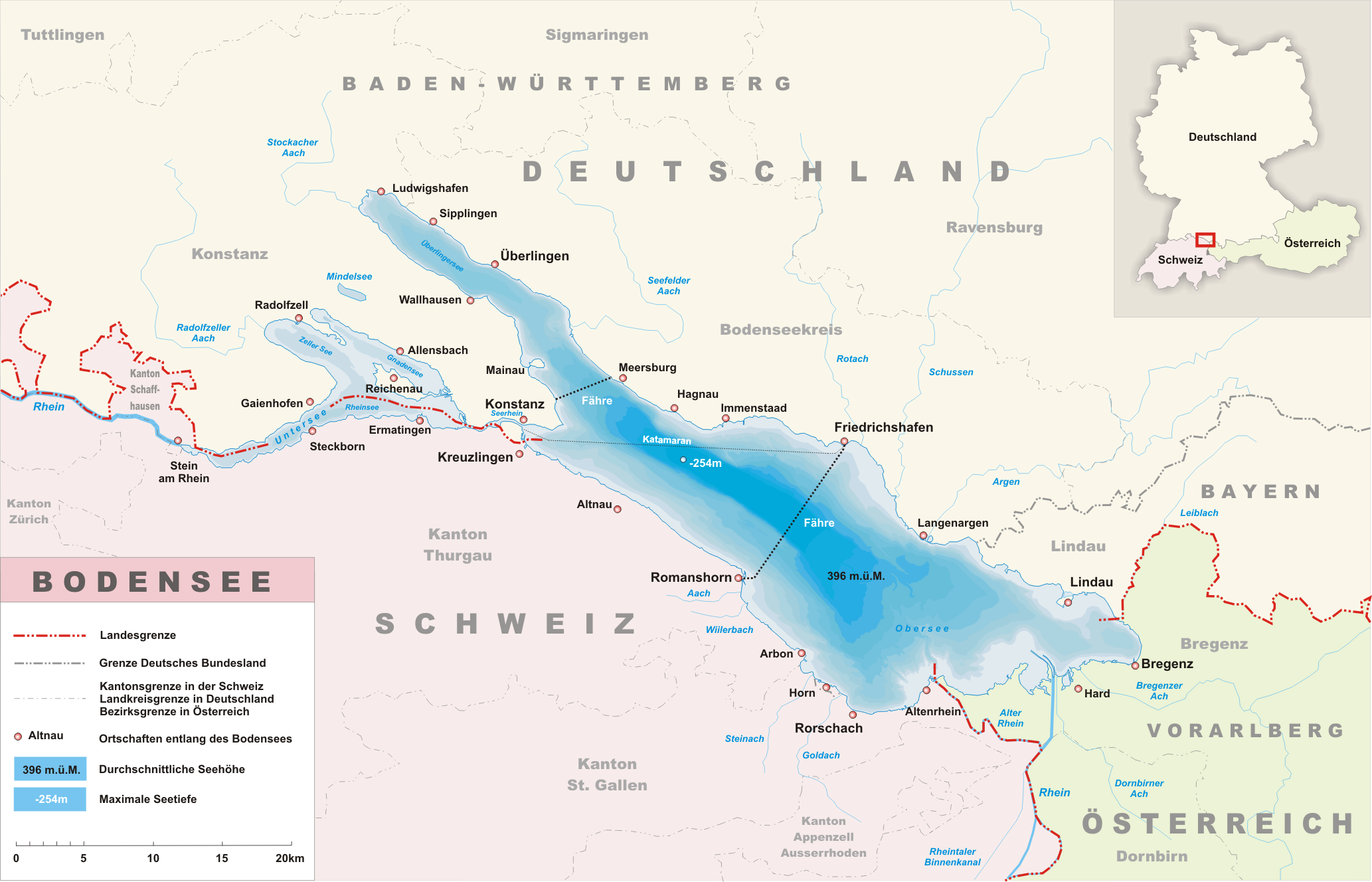
one more map would be helpful[edit]
A map that shows the broad outline of Germany, Austria and Switzerland and how L. Constance lies in that niche. The maps here are nice for seeing the details of the lake and towns on it, but you don't get a feel for the lake in terms of the 3 countries and location within Europe itself. Basically something similar to the map on the page for Konstanz (town of Constance), but showing all three countries at size, not just Germany. I would add one, but I don't know how. BTW, it seems in general that wikipedia is weak on maps. TCO (talk) 17:49, 29 November 2008 (UTC)
the meaning of the name in German[edit]
What is the historical reason of calling it the Bodensee? "Bottom lake", "floor/ground lake", or at the bottom of the Rhine River or what? Anyone know? —Preceding unsigned comment added by 125.84.82.56 (talk) 06:06, 13 January 2010 (UTC)
- The German name is not derived from the word "Boden", meaning ground/bottom. There's a municipality called Bodman (today it's called Bodman-Ludwigshafen - these two villages have merged to reduce the expenses for the administration) located close to the lake. Bodman used to be an important place at the lake (the Carolingian dynasty had built a so called Kaiserpfalz, a palace serving as a temporary seat of power for the emperor of the HRE, near Bodman in the 9th century (ruins are still visible today). The original name was Bodmansee - derived from the name "Bodman". This name has changed several times in the past Bodmansee => Bodansee => Bodensee.Johnny2323 (talk) 21:23, 14 February 2010 (UTC)
Wow! Great explanation. Does the fact that perhaps the word/place name went from dialect/alemanic German to Hochdeutsch have anything to do with the modern name used now? —Preceding unsigned comment added by 125.84.185.82 (talk) 15:09, 9 March 2010 (UTC)
Peninsula between Untersee and Überlinger See is called "Bodanrück" ManfredV (talk) 19:31, 25 August 2017 (UTC)
Google maps[edit]
On google maps there are borders. Google doesn't show some kind of condominium. Did they simply draw these borders themselves or are there any further agreements concerning the borders? Johnny2323 (talk) 20:59, 24 September 2010 (UTC)
- I think google just draw the borders themselves or a software from google did it itself. The borders were definitely wrong in the past. At the moment, there are no borders on the lake in google maps, which is much less confusing than before. However, there are no acknowledged borders on the Obersee. You can see the borders in these two images: overview and more detailed.--Markus Bodensee (talk) 00:07, 16 July 2013 (UTC)
Lake volume inconsistency[edit]
It says lake Constance covers 536 km^2, and is on average 90 m deep. This would make its volume 536*0.09 = 48 km^3. But the article says 10^10 m^3 (= 10 km^3). — Preceding unsigned comment added by 140.160.8.189 (talk) 13:19, 16 March 2012 (UTC)
Undefined Borders[edit]
Is the quote "Lake Constance is the only area in Europe where no borders exist, because there is no legally binding agreement as to where the borders lie between Switzerland, Germany and Austria" factually correct - it would seem to contradict the information given in the Republic_of_Ireland–United_Kingdom_border#Waters_around_Northern_Ireland article regarding unresolved UK/Republic of Ireland borders.
92.10.38.115 (talk) 22:05, 4 January 2014 (UTC)
Islands list[edit]
The list is incomplete. There are some more, f.e. Vogelinsel near Lindau, Vogelinseln/Dorniermole near Immenstaad, Wollsäuliinsel at Kreuzlingen ManfredV (talk) 19:27, 25 August 2017 (UTC)
External links modified[edit]
Hello fellow Wikipedians,
I have just modified 3 external links on Lake Constance. Please take a moment to review my edit. If you have any questions, or need the bot to ignore the links, or the page altogether, please visit this simple FaQ for additional information. I made the following changes:
- Added archive https://web.archive.org/web/20120514054950/http://www.hydra-institute.com/igkb/IGKB%201.2.pdf to http://www.hydra-institute.com/igkb/IGKB%201.2.pdf
- Added archive https://web.archive.org/web/20120514054950/http://www.hydra-institute.com/igkb/IGKB%201.2.pdf to http://www.hydra-institute.com/igkb/IGKB%201.2.pdf
- Added archive https://web.archive.org/web/20160919054010/http://www.bodensee-ornis.de/informationen-zum-bodensee/beobachtungsgebiete/ to http://www.bodensee-ornis.de/informationen-zum-bodensee/beobachtungsgebiete/
When you have finished reviewing my changes, you may follow the instructions on the template below to fix any issues with the URLs.
This message was posted before February 2018. After February 2018, "External links modified" talk page sections are no longer generated or monitored by InternetArchiveBot. No special action is required regarding these talk page notices, other than regular verification using the archive tool instructions below. Editors have permission to delete these "External links modified" talk page sections if they want to de-clutter talk pages, but see the RfC before doing mass systematic removals. This message is updated dynamically through the template {{source check}} (last update: 18 January 2022).
- If you have discovered URLs which were erroneously considered dead by the bot, you can report them with this tool.
- If you found an error with any archives or the URLs themselves, you can fix them with this tool.
Cheers.—InternetArchiveBot (Report bug) 19:08, 15 December 2017 (UTC)
Unreasonable changes by User:TheCorlos1975[edit]
User:TheCarlos1975 boldly changed the leading paragraph several times changing the primarily longstanding geographical focus to a national one, pronouncing mainly a national POV. I don't see a good reason to do so. The geographical description follows of course the flow of water. He is invited to argue about a better solution here. And he is asked to adhere to the WP:BRD policy. -- ZH8000 (talk) 01:53, 25 April 2019 (UTC)
- Hello ZH8000. It would be nice if you would explain why you think it is more appropriate to mention
- a) Bavaria before Baden-Württemberg although 1) Baden-Württemberg has the longer shoreline of the two states and 2) even alphabetically, Baden-Württemberg would be first
- b) Vorarlberg before the three Swiss cantons although again the Swiss cantons have the longer shoreline plus in the sentence before, Switzerland is mentioned before Austria
- My suggestion was mentioning the regions according to a) the corresponding countries, b) the length of the shoreline:
- Germany, Switzerland, Austria → Baden-Württemberg, Bavaria, Thurgau, St. Gallen, Schaffhausen, Vorarlberg TheCarlos1975 (talk) 11:00, 25 April 2019 (UTC)
- @TheCarlos1975:, firstly, please adhere to the WP:TALK rules.
- Because, it follows – as I already mentioned above – a geographical-based approach: namely according the flow of water, which is a quite the common way. As simple as convincing it is. Full stop. And I do not see any reason to change this habit just in the case of Lake Constance. -- ZH8000 (talk) 11:59, 29 April 2019 (UTC)
- There's nothing in the guidance for Wikipedia:WikiProject Lakes that shows any preference for how countries are listed around a lake. Not all articles on lakes use the "flow of water" argument (see Lake Maggiore) or how would you even come up with a "flow of water" for a place like Narva Reservoir where the rivers and lake form the border? Additionally, who's to say that water which flowed into Lake Constance would reach the Bavarian coast before it reached the Swiss coast? To me length of coast line makes as much geographic sense as "flow of water", and I suspect that the schemes used to decide which country is listed first have as much diversity as the editors who created the pages.Tobyc75 (talk) 13:02, 29 April 2019 (UTC)
- Frankly, this is a storm in a teacup. To the average reader I suspect it really makes no odds whether the sequence is alphabetical or geographical, especially if it is made clear later in the text. Bermicourt (talk) 12:24, 27 May 2019 (UTC)
Names[edit]
In the article it says the Untersee was called Lacus Acronius and the Obersee was called Lacus Venetus, but in the 1540 map that is shown (and other historic maps I can find), it has it the other way around. --Lasunncty (talk) 11:18, 9 May 2020 (UTC)
infobox pushpin map[edit]
@Tobyc75: I agree that "Austria map only shows a tiny corner of the lake, which is shared between multiple countries". The point of the pushpinmap is to help orient people unfamiliar with the location to have a better idea where it may be and even with a partial display it serves that point, but it can be better and it should be. Could you suggest a better pushpin map to use, else it will go into the queue of needs better pushpin map than country level. CheersWolfgang8741 says: If not you, then who? (talk) 13:35, 8 July 2020 (UTC)
- What do you think about this, with Central Europe and Europe?Tobyc75 (talk) 15:30, 8 July 2020 (UTC)
- From a functional orientation it looks good as a way to orient someone to the location. From a consistency (more broadly something needing to be evaluated and discussed across pushpin map styles within and across all lake articles) it is a bit odd to have a border only map for Central Europe and styled map with terrain for Europe as a whole. Thanks, that is a fix for now. Wolfgang8741 says: If not you, then who? (talk) 03:43, 9 July 2020 (UTC)
- Yeah, I can't figure out why it's doing that. According to the Module:Location map/data/Europe the blank border map should be the first one loaded and the relief map is secondary.Tobyc75 (talk) 18:47, 9 July 2020 (UTC)
- From a functional orientation it looks good as a way to orient someone to the location. From a consistency (more broadly something needing to be evaluated and discussed across pushpin map styles within and across all lake articles) it is a bit odd to have a border only map for Central Europe and styled map with terrain for Europe as a whole. Thanks, that is a fix for now. Wolfgang8741 says: If not you, then who? (talk) 03:43, 9 July 2020 (UTC)
waterbodies isn't a word[edit]
I edited "waterbodies" to be "bodies of water" and it was reverted with the note that "waterbodies is a perfectly valid English word." I'm a native English speaker, and I've never heard it. Just in case, I checked all the online English dictionaries and couldn't find it. I don't want to get into an edit war over something so silly, so I'm putting this note here instead. --Sam (talk) 00:04, 21 July 2020 (UTC)
- C-Class vital articles
- Wikipedia level-5 vital articles
- Wikipedia vital articles in Geography
- C-Class level-5 vital articles
- Wikipedia level-5 vital articles in Geography
- C-Class vital articles in Geography
- C-Class Lakes articles
- High-importance Lakes articles
- WikiProject Lakes articles
- C-Class Germany articles
- High-importance Germany articles
- WikiProject Germany articles
- C-Class Switzerland articles
- High-importance Switzerland articles
- All WikiProject Switzerland pages
- C-Class Austria articles
- Mid-importance Austria articles
- All WikiProject Austria pages
- C-Class Bavaria articles
- Mid-importance Bavaria articles
- WikiProject Bavaria articles
- Pages translated from German Wikipedia