
Talk:Control of cities during the Syrian civil war/Archive 63
| This is an archive of past discussions. Do not edit the contents of this page. If you wish to start a new discussion or revive an old one, please do so on the current talk page. |
| Archive 60 | Archive 61 | Archive 62 | Archive 63 | Archive 64 | Archive 65 |
Dot size
Pbfreespace3 Re [1] According to the Rules for Editing the Map, dot size for cities & towns (that are not provincial capitals) is based on the 2004 census (last available census), and 3,681 is under 5,000 and that is size 6. Ref, Module:Syrian_Civil_War_detailed_map#Dot_size_guide_for_cities_.26_towns. Erlbaeko (talk) 21:32, 16 August 2016 (UTC) 5,000 was size 6 until Pbfreespace3 changed it on 16 August 2016 at 21:50 UTC, ref diff Erlbaeko (talk) 22:07, 16 August 2016 (UTC)
Jubb al Katashli, Aqra mountains, Umm al-Saraj Mountain and Qur'a Saghira
User:Lists129, re. [2]. Yes, I know. That's why I removed them instead of changing them to SDF. I can remove information that is not sourced. You need a source to restore it. Ref. WP:BURDEN. Erlbaeko (talk) 15:19, 13 August 2016 (UTC)
- Here is another map that indicates that Jubb al Katashli, Aqra mountains, Umm al-Saraj Mountain and Qur'a Saghira is under SDF control. So, as the user that restored the material, do you have a source that says they are still under IS control? Erlbaeko (talk) 15:28, 13 August 2016 (UTC)
- Erlbaeko first read the rules of editing [3],they were well sourced,check diffs.Lists129 (talk) 15:34, 13 August 2016 (UTC)
- I have read the rules. Have you read WP:BURDEN? It says: "The burden to demonstrate verifiability lies with the editor who adds or restores material. So, do you have a source that says it is still under IS control? Erlbaeko (talk) 15:44, 13 August 2016 (UTC)
- Erlbaeko if you have read the rules,then why you provide a map as a source? sources were provided for these place check diffs-do you understand what diff is?Lists129 (talk) 15:57, 13 August 2016 (UTC)
- Lists129 Yes, I do understand what diff is. This is a diff. In that diff you restored material, and you did so without demonstrating verifiability, as you should have done according to our policy on verifiability. I did not provide the map as a source, but as a reason for removal of poorly sourced material. Do you understand the difference? Erlbaeko (talk) 16:14, 13 August 2016 (UTC)
- Erlbaeko if you have read the rules,then why you provide a map as a source? sources were provided for these place check diffs-do you understand what diff is?Lists129 (talk) 15:57, 13 August 2016 (UTC)
- I have read the rules. Have you read WP:BURDEN? It says: "The burden to demonstrate verifiability lies with the editor who adds or restores material. So, do you have a source that says it is still under IS control? Erlbaeko (talk) 15:44, 13 August 2016 (UTC)
Maybe this?link Mehmedsons (talk) 16:19, 13 August 2016 (UTC)
- Erlbaeko I understand, But you are not understanding the reason that I reverted you is that you didn't provide a reliable source for removing these places that were added with realiable sources.Lists129 (talk) 16:27, 13 August 2016 (UTC)
- I don't need to provide a reliable source for removing these places, and I don't agree that I need to digg into the revision history of the module page to see if I can find something that indicates that these places are under IS control. That is your jobb if you like to resotre material. Again, that burden is on the user that restor material. Erlbaeko (talk) 16:52, 13 August 2016 (UTC)
- Erlbaeko I understand, But you are not understanding the reason that I reverted you is that you didn't provide a reliable source for removing these places that were added with realiable sources.Lists129 (talk) 16:27, 13 August 2016 (UTC)
- Erlbaeko actually you need to provide a source(reliable one) to change the status of that place but you cant remove them beacause all these places in this template were all added with verifiable facts(reliable sources) in the past,you can remove a place when that place is added without a source or you can remove it temporary if there are disputes between 2 reliable sources(when they claim that is held by both parties),in this point you dont have any reliable source just a pro-biased map source which is prohbited by the rules of editing.Lists129 (talk) 18:59, 14 August 2016 (UTC)
Iwan123Iwan Re.[4] Thanks for adding a source when you restore material, but the article says "ISIS alleged that they captured...". We can not use ISIS claims for edits that are favorable to their side. Erlbaeko (talk) 21:14, 16 August 2016 (UTC)
- http://mobile.almasdarnews.com -It is a reliable anti-Isis source.If information was false then this source would not be reported. — Preceding unsigned comment added by Iwan123Iwan (talk • contribs) 14:44, 17 August 2016 (UTC)
Rai border crossing
Does al-Rai even has one? From sattelite images it would appear that its transit terminal for trains, but I dont know if that qualifies as border crossing given that no trains run between Syria and Turkey for 5 years now. EllsworthSK (talk) 16:48, 17 August 2016 (UTC)
- It depends on how you classify a border crossing. It certainly has a big road traveling from Turkey through the town down south. There are many unofficial border crossing where supplies are shipped and fighters transferred, but they aren't marked. I'd say mark the al-Ra'i border crossing, as it was an important point on the border. Pbfreespace3 (talk) 16:59, 17 August 2016 (UTC)
- The road is in its entirety on syrian proper. There is no road that crosses the border. And what you have in mind are smugglers route. One of the popular ones is north of Mabroukah, yet it isnt marked as border crossing as, obviously, its not one. This bugged me for a while, but only thing that could make it a border crossing would be the aformenetioned railtrack that doesnt operate for 5 years and given the widespread destruction of Aleppo railhub, even if the war would end today, wouldnt operate for many years. And if we take that as criteria, shouldnt we mark village of Meidan Ekbis here [5] as border crossing? EllsworthSK (talk) 17:10, 17 August 2016 (UTC)
- This source makes it very clear that it is a border crossing, as well as a popular smuggling point from Turkey. Perhaps it is widely seen as one, even if it isn't official. Pbfreespace3 (talk) 17:38, 17 August 2016 (UTC)
- What? That same source says this village [6] is a crossing too. Absolutely obviously it talks about points where ISIS smuggled fighters, not as official border crossing. As an example here [7] is list of Syrian border crossings with ar-Rai not included. Not to mention that, again, there is no road, nor any border gate, nor any border customs aside of railtrack. EllsworthSK (talk) 18:07, 17 August 2016 (UTC)
- This source makes it very clear that it is a border crossing, as well as a popular smuggling point from Turkey. Perhaps it is widely seen as one, even if it isn't official. Pbfreespace3 (talk) 17:38, 17 August 2016 (UTC)
- The road is in its entirety on syrian proper. There is no road that crosses the border. And what you have in mind are smugglers route. One of the popular ones is north of Mabroukah, yet it isnt marked as border crossing as, obviously, its not one. This bugged me for a while, but only thing that could make it a border crossing would be the aformenetioned railtrack that doesnt operate for 5 years and given the widespread destruction of Aleppo railhub, even if the war would end today, wouldnt operate for many years. And if we take that as criteria, shouldnt we mark village of Meidan Ekbis here [5] as border crossing? EllsworthSK (talk) 17:10, 17 August 2016 (UTC)
Revert of edit by Warszawiak22
Warszawiak22, can you please explain for what reason you reverted my edit despite me giving a detailed explanation about why I reverted Ahmedo Semsuri's edit? I specifically explained that the source does not fulfill the criteria of Wikipedia's rule WP:SOCIALMEDIA. Self-published sources like posts of Twitter. users cannot be used as a reliabe source for information about a third-party, it specifically says that. Not to mention, social network posts are usually not reliable as anyone can post whatever they like. You however reverted my edit without giving any reason. The source used by Ahmedo Semsuri cannot be considered reliable as per Wikipedia rules. Newsboy39 (talk) 16:36, 18 August 2016 (UTC)
al-Hasakah situation?
al-Hasakah is in the last 12 hours be contested between SDF/QSD local police forces (Asayish) and NDF pro-Syrian government forces, why is not that on the map? Geosapiens (talk) 06:24, 18 August 2016 (UTC)
- Done. Pbfreespace3 (talk) 19:46, 18 August 2016 (UTC)
Semi-protected edit request on 18 August 2016
This edit request to Module:Syrian Civil War detailed map has been answered. Set the |answered= or |ans= parameter to no to reactivate your request. |
95.158.37.248 (talk) 14:02, 18 August 2016 (UTC)
caption = [=[Hold cursor over location to display name; click to go to sources &/or status description (if available, the cursor will show as ![]() ; if not, it will show as
; if not, it will show as ![]() ).
).
![]() Government ;
Government ; ![]() Opposition ;
Opposition ; ![]() SDF (Syrian Democratic Forces (And Affiliates) ;
SDF (Syrian Democratic Forces (And Affiliates) ; ![]() Jabhat Fateh al-Sham (JFS) ;
Jabhat Fateh al-Sham (JFS) ; ![]() Islamic State (IS)
Islamic State (IS)
![]() Contested ;
Contested ; ![]() Stable mixed control ;
Stable mixed control ; ![]() Government & Opposition (truce)
Government & Opposition (truce)
![]() Inner controls, outer sieges (or strong enemy pressure) ;
Inner controls, outer sieges (or strong enemy pressure) ; ![]() Enemy pressure from one side; Small icon within a larger icon: The situation in individual neighbourhood/district
Enemy pressure from one side; Small icon within a larger icon: The situation in individual neighbourhood/district
![]() Airport/Air base ;
Airport/Air base ; ![]() Heliport/Helicopter base ;
Heliport/Helicopter base ; ![]() Military base ;
Military base ; ![]() Strategic hill ;
Strategic hill ; ![]() Oil/gas ;
Oil/gas ; ![]() Industrial complex ;
Industrial complex ; ![]() Border Post ;
Border Post ; ![]() Major port or naval base ;
Major port or naval base ; ![]() Dam ;
Dam ; ![]() Rural presence]=]
}
Rural presence]=]
}
- This is a confusing request, but I think I know what you want, and no. The government should be red to contrast with the green of the rebels. Pbfreespace3 (talk) 19:30, 18 August 2016 (UTC)
 Not done: please establish a consensus for this alteration before using the
 {{edit semi-protected}}template. nyuszika7h (talk) 09:44, 19 August 2016 (UTC)
al-Ra´i city/village source to backup change to FSA
Where are your sources to change that city/village to the FSA? In my view could be "contested" between both!!! But no sources backup any prove that the FSA holds that!!! Geosapiens (talk) 06:24, 18 August 2016 (UTC)
- Well it doesn't matter now, because ISIS retook it again. Pbfreespace3 (talk) 17:09, 19 August 2016 (UTC)
- Hello Pbfreespace3 the al--Ra´i city/village still are in the FSA control!!! I don't find any sources that backup that "conquest". ISIS still have that Syrian city/village. Best regards Geosapiens (talk) 13:24, 22 August 2016 (UTC)
Arab Hasan Kabir under SDF
- Here is an anti-SDF rource which reported ISIS retreated from the village: https://twitter.com/manbejmubashar1/status/766353801628397568
- Here is ANHA (pro-SDF) admitting they secured the villages alongside a number of other villages. http://www.hawarnews.com/%D9%85%D9%82%D8%AA%D9%84-75-%D9%85%D8%B1%D8%AA%D8%B2%D9%82%D8%A7%D9%8B-%D9%88%D8%AA%D8%AD%D8%B1%D9%8A%D8%B1-14-%D9%82%D8%B1%D9%8A%D8%A9-%D8%AE%D9%84%D8%A7%D9%84-%D9%8A%D9%88%D9%85%D9%8A%D9%86/
- Moreover local activities report that about 10 other villages northeast/northwest of Manbij have been captured by SDF, not updated on the map and still shown in black. Roboskiye (talk) 07:43, 22 August 2016 (UTC)
- Found a source for some villages north of Manbij under SDF control, including Arab Hasan, al-Kusa, Zahr al-Magharah: http://www.akhbaralaan.net/news/arabs/2016/8/22/%D8%AF%D8%A7%D8%B9%D8%B4-%D9%81%D9%8A-%D8%A7%D9%86%D9%87%D9%8A%D8%A7%D8%B1-%D9%88%D8%AC%D8%B1%D8%A7%D8%A8%D9%84%D8%B3-%D8%A8%D9%8A%D9%86-%D8%A7%D9%84%D8%AB%D9%88%D8%A7%D8%B1-%D9%88%D9%82%D9%88%D8%A7%D8%AA-%D8%B3%D9%88%D8%B1%D9%8A%D8%A7-%D8%A7%D9%84%D8%AF%D9%8A%D9%85%D9%82%D8%B1%D8%A7%D8%B7%D9%8A%D8%A9 Roboskiye (talk) 21:39, 22 August 2016 (UTC)
Hasakah Fuel Depot & Military Housing
Since latest offensive by kurdish forces, they have been able to capture the fuel depot and most of Gweiran neighborhood, as per pro-govt user Hassan Ridha:
https://twitter.com/sayed_ridha/status/767705101213376512
I suggest the item is changed to yellow, pending changes to the svg map for other kurdish gains confirmed by both pro-govt and kurdish sources.
191.109.98.245 (talk) 02:11, 23 August 2016 (UTC)
Regime will leave Hasaka
The ceasefire between YPG and the Regime includes an agreement that the regime will leave the city for Kawkab base. I therefore propose that we change the status of the city to Kurdish-controlled. This is confirmed by both sides [8] --Ahmedo Semsurî (talk) 17:04, 23 August 2016 (UTC)
Surprise Regime attack in the Golan
According to this website that shows up on google news https://www.almasdarnews.com/article/syrian-army-begins-surprise-offensive-golan-heights/
the small town of al 'Ajraf has fallen to loyalist forces. And the town directly to its south-east "Umm Batinah" is being assaulted. So Umm Batinah should have a red line arounds the top of the green circle. If this source is to be trusted.. — Preceding unsigned comment added by 68.6.127.235 (talk) 04:25, 24 August 2016 (UTC)
South Al-Shadad
https://www.almasdarnews.com/article/isis-continues-advance-key-city-southern-hasakah/ mentions that IS a positioned south of Al-Shaddadi and some villages have been taken by IS on the way without spelling their names. We should probably turn black anything south of Al-Shaddadi.Paolowalter (talk) 15:12, 24 August 2016 (UTC)
Tal Rifaat and Marea in northern Aleppo province
Ahmedo Semsurî Re [9]. According to this RT-article, Tal Rifaat and Marea is controlled by YPG. Do you have a source that indicates that this "Must be a mistake" or do I need to take your word for it? Erlbaeko (talk) 11:55, 22 August 2016 (UTC)
- Report on Mare' 5 days ago [10]. Under "extremist" control. --Ahmedo Semsurî (talk) 11:57, 22 August 2016 (UTC)
- If Mare' was captured by SDF, it should be very easy to find Kurdish sources verifying it. --Ahmedo Semsurî (talk) 11:58, 22 August 2016 (UTC)
- That article do not say Marea is under "extremist" control. It says it's rebel-held. Anyway, that is old news. Yesterday it was reported by this Reuters-article, that Ahrar al-Sham are now "aiming to regain control of the strategic towns of Tal Rifaat and Marea in the northern Aleppo countryside, currently in the hands of the YPG." So, both RT and Reuters says it's YPG controlled. Erlbaeko (talk) 12:16, 22 August 2016 (UTC)
- And so do this Al Arabiya article. Erlbaeko (talk) 12:28, 22 August 2016 (UTC)
- That article do not say Marea is under "extremist" control. It says it's rebel-held. Anyway, that is old news. Yesterday it was reported by this Reuters-article, that Ahrar al-Sham are now "aiming to regain control of the strategic towns of Tal Rifaat and Marea in the northern Aleppo countryside, currently in the hands of the YPG." So, both RT and Reuters says it's YPG controlled. Erlbaeko (talk) 12:16, 22 August 2016 (UTC)
- If Mare' was captured by SDF, it should be very easy to find Kurdish sources verifying it. --Ahmedo Semsurî (talk) 11:58, 22 August 2016 (UTC)
- You can change it to SDF then. But I would still wait for Kurdish sources - Marea is not some random village, but a FSA stronghold as Azaz. --Ahmedo Semsurî (talk) 12:43, 22 August 2016 (UTC)
Mare is not under YPG control. YPG doesn't even control Shaykh Issa; that town is controlled by Jaish Thuwwar (which is part of SDF). Ahrar wants Mare because Mare has only other rebels in it (largely Turkmen and FSA). The Reuters article claiming YPG controls Mare is just wrong. That al-Arabiya article is just a copy of Reuters. Pbfreespace3 (talk) 14:25, 22 August 2016 (UTC)
- We all know Mare' was green. If Royter just says it is yellow out from nothing that is bogas. I need a link stating that yellow/SFD/YPG controoled Mare' . You know that cont just happen majically . no MAre' will stay Green untill a source states that it changed status and how did that happen Helmy1453 (talk) 13:19, 24 August 2016 (UTC)
- Changed it to SDF since we should use reliable sources, and multiple RS do say Marea is under YPG control. Erlbaeko (talk) 09:25, 23 August 2016 (UTC)
- The only reliable source that says this is Reuters (Al-Arabiya copied Reuters, they admitted as much), and I would argue they are not reliable in this case. This was a little Freudian slip. They meant to say that Shaykh Issa was under SDF control, but they misspoke. Every other source that exists says it's under rebel control. Every other source!
- Here's one that accurately predicted the Jarabulus offensive. Guess what she says? It's under rebel control. Pbfreespace3 (talk) 11:45, 24 August 2016 (UTC)
- I don't care about what you think Reuters meant to say. If you like to prove them wrong, you need a stronger source than a self-published tweet. But if "every other source" say so, it should be easy for you to find a good one. Be sure to post it here first. Erlbaeko (talk) 13:02, 24 August 2016 (UTC)
References
- ^ https://www.almasdarnews.com/article/rebels-advance-rapidly-amid-full-scale-isis-retreat-northern-aleppo-map-update/
- ^ http://qasioun.net/en/news/show/28405/Opposition_break_the_siege_by_ISIS_on_Mare%E2%80%99a
- ^ http://www.syriahr.com/2016/06/08/%D8%A7%D9%84%D9%81%D8%B5%D8%A7%D8%A6%D9%84-%D8%AA%D9%86%D9%81%D8%B0-%D9%87%D8%AC%D9%88%D9%85%D8%A7%D9%8B-%D9%85%D8%B9%D8%A7%D9%83%D8%B3%D8%A7%D9%8B-%D9%82%D8%B1%D8%A8-%D9%85%D8%AF%D9%8A%D9%86%D8%A9/
- ^ http://www.reuters.com/article/us-mideast-crisis-syria-northwest-idUSKCN0YU0PT
Qibab al Saghir, As Sakhanah, Arudah Kabirah, Khafsah Saghirah and Kaklijah
Coneleir Re [11] and [12]. You may be right that they are IS controlled, but you need a reliable source to add them to the map. None of your souces is a WP:RS, and the rules for editing the map above says that "Copying from maps is strictly prohibited". Erlbaeko (talk) 12:50, 22 August 2016 (UTC)
- The reason why maps were banned as a source is because they were mostly amateur maps by people with an agenda. For example, a lot of pro-government people would just put Nusra maps all over the rebel held area. Hanibal911 would mass change towns to Nusra. This was part of the reason. The more and more we see the maps like the one Coneleir used, and then we see these towns he marked as ISIS-controlled be captured by the Kurds, the more and more we see he is a reliable source, especially for towns held by ISIS. These towns are very important, have a decent population, and are about to be captured by SDF. One reason why I added them is so I don't have to find them later when they are captured. Pbfreespace3 (talk) 14:30, 22 August 2016 (UTC)
- Please, stop doing that. It's against the policy, and for all we know IS have never even been to all those places. Note that the policy on verifiability says "it is better to have no information, than to have information like this, with no sources." See the Further reading section. Erlbaeko (talk) 15:16, 22 August 2016 (UTC)
- Why did you just break that rule then? Pbfreespace3 (talk) 16:00, 22 August 2016 (UTC)
- I didn't. As that diff shows, I removed info. Erlbaeko (talk) 16:14, 22 August 2016 (UTC)
- You used this map to justify an edit on the Syrian civil war map. You directly contradicted the rules. Please don't criticize me if you make the same mistakes you claim I make. Pbfreespace3 (talk) 16:53, 22 August 2016 (UTC)
- I removed Umm al-Saraj Mountain, Qur'a Saghira and Aqra mountains, and said in my edit summary that: "Better source needed.". The map is not even needed to do that. So, no I did not made the same mistakes you claim you made. And btw, I said Coneleir made that mistake. Erlbaeko (talk) 17:17, 22 August 2016 (UTC)
- OK. Then you should've been clearer in addressing who you were talking to, Erlbaeko. The addition of these villages is justified because ISIS controls them, according to every source on the internet right now. Pbfreespace3 (talk) 17:58, 22 August 2016 (UTC)
- I removed Umm al-Saraj Mountain, Qur'a Saghira and Aqra mountains, and said in my edit summary that: "Better source needed.". The map is not even needed to do that. So, no I did not made the same mistakes you claim you made. And btw, I said Coneleir made that mistake. Erlbaeko (talk) 17:17, 22 August 2016 (UTC)
- I actually support adding villages which aren't directly at the frontline, especially in areas which are likely to be conquered by another side soon. It's another thing if you do it at not very well media-covered conflicts like the one in Yemen or Afghanistan, but in Syria, we have the frontlines really exact, village for village. If another faction would hold territory behind the frontlines, it would be reported immediately.--Ermanarich (talk) 16:54, 22 August 2016 (UTC)
- You used this map to justify an edit on the Syrian civil war map. You directly contradicted the rules. Please don't criticize me if you make the same mistakes you claim I make. Pbfreespace3 (talk) 16:53, 22 August 2016 (UTC)
- I didn't. As that diff shows, I removed info. Erlbaeko (talk) 16:14, 22 August 2016 (UTC)
- Why did you just break that rule then? Pbfreespace3 (talk) 16:00, 22 August 2016 (UTC)
- Please, stop doing that. It's against the policy, and for all we know IS have never even been to all those places. Note that the policy on verifiability says "it is better to have no information, than to have information like this, with no sources." See the Further reading section. Erlbaeko (talk) 15:16, 22 August 2016 (UTC)
I don't really care whether you support it or not. If you don't have a source, it fails WP:V. It says "Even if you're sure something is true, it must be verifiable before you can add it." Erlbaeko (talk) 18:00, 22 August 2016 (UTC)
- Well, but the problem here is, that the map won't be more accurate because of this but rather much more inaccurate, since the frontlines will contain much less villages then. I know this is somehow problematic to Wikipedia editing rules, but since the map editing follows special rules, is there no way to discuss this? I mean, this rule makes sense in a normal article, but here can't be a misinterpretation.--Ermanarich (talk) 20:15, 22 August 2016 (UTC)
- What is it to discuss? Rule no. 1 for editing the map, says "A reliable source for that specific edit should be provided." Rule no. 2 says "Copying from maps is strictly prohibited.", and rule no. 3 says "WP:POV pushing and intentional misinterpretation of sources will not be tolerated." Erlbaeko (talk) 21:58, 22 August 2016 (UTC)
- Well, this rules were obviously made before we had that many marks and informations about the Syrian as well as the Iraqi Civil War. I will not break the rules as long as we have them, but I think that it would be good to rediscuss this point.--Ermanarich (talk) 16:56, 23 August 2016 (UTC)
- I also concur with the above sentiment. We really need to discuss the rules of this map, because they are far too restrictive for us to actually show what's going on. There are so many sources we cannot use due to rule 59 chapter 5 paragraph c. Now that I see how difficult it is to actually make any changes on the module without being reverted by other users who throw the rulebook at everyone, I realize that we need more lax rules so we can edit instead of being bound by red tape. It is similar to crossing the street when there is not a light telling you you can do so, and a police officer instantly arresting you and giving you a big fine because you jaywalked. How would you ever drive or cross the street? We need to streamline and simplify the rules to ease editing, not make it harder for people to contribute. Pbfreespace3 (talk) 20:54, 24 August 2016 (UTC)
- Well, this rules were obviously made before we had that many marks and informations about the Syrian as well as the Iraqi Civil War. I will not break the rules as long as we have them, but I think that it would be good to rediscuss this point.--Ermanarich (talk) 16:56, 23 August 2016 (UTC)
- What is it to discuss? Rule no. 1 for editing the map, says "A reliable source for that specific edit should be provided." Rule no. 2 says "Copying from maps is strictly prohibited.", and rule no. 3 says "WP:POV pushing and intentional misinterpretation of sources will not be tolerated." Erlbaeko (talk) 21:58, 22 August 2016 (UTC)
Please don't use Twitter posts as a source
A lot of users here keep using Twitter posts of individuals as a source. Please note that Twitter posts of individuals cannot be regarded as reliable sources for information about third-parties as per WP:SOCIALMEDIA no matter what it claims. Newsboy39 (talk) 06:43, 19 August 2016 (UTC)
- I agree that most tweets are not usable, however, WP:SPS do mention an exception about self-published expert sources. To be used as an RS, the tweet needs to be from an expert (f.ex. a war correspondent) whose work has previously been published by a news organization (or from the news organizations official twitter account). As an example, since this article in The Daily Telegraph use tweets from Chuck Pfarrer, so can we(, but with caution). Erlbaeko (talk) 07:47, 19 August 2016 (UTC)
Thank you Erlbaeko, but some of the tweets being used are not from experts published by news sources. And even when they are experts, they do nlt say the users claim they do. For example many users have used this post saying it claims that Amaq News Agency says Hamar Labidah village has been captured by SDF. However neither it mentions Amaq nor does it say anywhere Hamar Labidah has been captured by SDF. It only talks about a suicide bombing in the village. And a suicide bombing does not automatically mean the opposite faction controls the village, such a bombing can even be carried out during a battle. Users should be more careful. Newsboy39 (talk) 09:34, 19 August 2016 (UTC)
- Based on your words here, I can assume that you are unfamiliar with Amaq News Agency. It is the major pro-ISIS 'news' group that exists. Since it can easily be taken down by authorities, it relies upon social media platforms like Twitter to spreads its propaganda. It uses a distinct format to disseminate it's message which you can easily see based on the style of the announcement. Note that "Islamic State" appears in the top right corner, and it refers to ISIS soldiers with friendly terms. This is a reliable source when it gives to reporting ISIS losses. Pbfreespace3 (talk) 12:14, 19 August 2016 (UTC)
- I already pledged not to use Twitter in the past, but I think now that we should do it a bit different and create a list of reliable Twitter accounts. A similiar thing was done for the Yemeni Civil War map template. In the past I saw for example, that someone used Julian Roepcke as a source. This Twitter account is incredible biased and can absolutely not used as a source. One other thing, expecially to you, Newsboy39: If a biased source admits a defeat of the own side, it can be used.--Ermanarich (talk) 15:38, 19 August 2016 (UTC)
Here is a list of reliable sources that I will edit as needed:
- Chuck Pfarrer
- AL-Masdar News (when other reliable sources don't contradict)
- SOHR (same as above)
Will add more as needed. Pbfreespace3 (talk) 15:56, 19 August 2016 (UTC)
Ermanarich Have you even read the source? The source is not from Amaq News Agency, nor does it mention it and is not admitting defeat. I've repeated this multiple times. Here's the tweet itself:
#SYRIA
- IslamicState Claims Suicide Attack On #YPG Fighters In Haymar Labidah Village,S #Manbij City. #TerrorMonit…
It NEVER ADMITTED DEFEAT. Neither Amaq is mentioned. Newsboy39 (talk) 16:08, 19 August 2016 (UTC)
- Calm down, no need to get emotional. DaeshDaily cites Amaq there too, it's saying exactly the same words: http://www.daeshdaily.com/august-18-2016/ And regarding the masses of defeats the Islamic State is currently facing, Amaq would absolutely never miss to mention a victory over its enemies.--Ermanarich (talk) 16:21, 19 August 2016 (UTC)
Ermanarich Well looks like it is from Amaq. The content however nowhere admits any defeat, it's only mentioning a suicide bombing. Why do people keep claiming it admitted defeat in Haymar Labidah when it never did? Newsboy39 (talk) 16:27, 19 August 2016 (UTC)
- Did you notice the image in the tweet? That do say Amaq News Agency, and also that a "martyrdom operation" hit a group of YPG fighters in the village of Haymar Labidah. So, it's not unlikely that is under SDF control, but I agree that we need a better source to say it for sure. Erlbaeko (talk) 16:49, 19 August 2016 (UTC)
- Erlbaeko A suicide attack can also be carried out at a place during a battle. ISIS has regularly used it during battles. Newsboy39 (talk) 16:58, 19 August 2016 (UTC)
- I agree. I just dit not understand why you said that Amaq wasn't mentioned. Erlbaeko (talk) 17:03, 19 August 2016 (UTC)
- Newsboy, do you have any sources that day there is ongoing fighting in Hamir Labidah town? Because if you don't, it is safer to say it is under YPG control. Pbfreespace3 (talk) 17:07, 19 August 2016 (UTC)
- Ok then. I've researched a little bit. Media outside from Twitter didn't report about this village yet. Twitter has some posts about it: (https://twitter.com/search?q=Labidah&src=typd&lang=de) and one we should be able to use, since he is one of the Twitter accounts which helped Chuck Pfarrer to create the Manbij Tacmap: https://twitter.com/calimike1/status/766028517880455168 Also, there were reports from two hours ago, that another suicide attack happened, which means that it's either held by the SDF or contested. As long as the situation remains that unclear, I'd put Hamir Labidah as contested.--Ermanarich (talk) 17:11, 19 August 2016 (UTC)
- See also this report from Al Jazeera. Erlbaeko (talk) 17:20, 19 August 2016 (UTC)
- Ok then. I've researched a little bit. Media outside from Twitter didn't report about this village yet. Twitter has some posts about it: (https://twitter.com/search?q=Labidah&src=typd&lang=de) and one we should be able to use, since he is one of the Twitter accounts which helped Chuck Pfarrer to create the Manbij Tacmap: https://twitter.com/calimike1/status/766028517880455168 Also, there were reports from two hours ago, that another suicide attack happened, which means that it's either held by the SDF or contested. As long as the situation remains that unclear, I'd put Hamir Labidah as contested.--Ermanarich (talk) 17:11, 19 August 2016 (UTC)
- Newsboy, do you have any sources that day there is ongoing fighting in Hamir Labidah town? Because if you don't, it is safer to say it is under YPG control. Pbfreespace3 (talk) 17:07, 19 August 2016 (UTC)
- I agree. I just dit not understand why you said that Amaq wasn't mentioned. Erlbaeko (talk) 17:03, 19 August 2016 (UTC)
- Erlbaeko A suicide attack can also be carried out at a place during a battle. ISIS has regularly used it during battles. Newsboy39 (talk) 16:58, 19 August 2016 (UTC)
And as we're at unclear situations already: I've heard about reports, that the Rebels in al-Rai claim to have repelled the ISIL-attack...--Ermanarich (talk) 17:14, 19 August 2016 (UTC)
I can't understand Arabic. The Google Translation of source by Erlbaeko says "The agency said that another car bomb attack Thursday targeted a gathering of the Kurdish units in the village Himr in situ south Manbej Brive Aleppo east during the progress of those troops toward state regulation sites under US air cover." Is it confirmation of a battle or victory? I can't understand the broken translation. Is anybody a native Arabic speaker here? Newsboy39 (talk) 18:12, 19 August 2016 (UTC)
Ermanarich ISIS has recaptured al-Rai after losing it for just a day: https://www.almasdarnews.com/article/isis-recaptures-key-town-northern-aleppo/
A good source says Hamir Labidah is under SDF control. Pbfreespace3 (talk) 03:46, 20 August 2016 (UTC)
I agree it's a good source User:Pbfreespace3, the author is an expert according to his credentials. Good job on finding a reliable source that does indeed talk about Haymar Labidah's capture. Newsboy39 (talk) 17:41, 20 August 2016 (UTC)
- Is expert? The author is syrian living in US whose upside is that he is fluent in arabic and reads a lot of social media pages of activists or group that mostly publish in arabic. By what claim is he an "expert"? Does he has credential as correspondent? Does he fulfill the creteria of notability? Reliability? You cannot just go around and just call expert anyone you see, even though this is an internet where every shmuck is a PhD. EllsworthSK (talk) 18:33, 21 August 2016 (UTC)
Hm yes I guess you're right. His credentials said he was a history major and was an analyser of the Middle Eastern civil wars. Based on that I thought he was a scholar covering the Syrian civil war. Though this is not the case. Does not seem to be an expert as I don't see any newspaper using him as a source oremplying him. Newsboy39 (talk) 06:43, 22 August 2016 (UTC)
Since few seem to be able to pick out objective and authorized sources on Twitter, I think twitter sources should be banned all together. 9/10 twitter sources are private accounts. Mozad655 (talk) 21:02, 24 August 2016 (UTC)
Daraya
https://www.almasdarnews.com/article/daraya-handed-syrian-army-following-agreement/ states that Daraya surrended to the army. Some rebels will be relocated and then the city will be in full government control. I think we can turn it red.Paolowalter (talk) 09:33, 25 August 2016 (UTC)
- Almas is not a reliable source. Its affiliated with the syrian regime. We have to wait for confirmation from neutral or opposition media and even then wait more until the actual hand-over has taken place. 87.60.188.96 (talk) 11:03, 25 August 2016 (UTC)
- A similar situation happened with the Waer neighborhood in Homs. They had agreed to evacuate it, but a year later it is still rebel held. We should wait, as Daraya has hundreds of rebel fighters. Pbfreespace3 (talk) 14:27, 25 August 2016 (UTC)
- We cannot just ignore it, situation changed completely. As Waer neighborhood in Homs should be turned at least violet (truce).Paolowalter (talk) 15:57, 25 August 2016 (UTC)
No change is needed. al-Masdar cannot be used to back Syrian regime gains. This should be noted and looked into, but with no one else reporting on it, it shouldn't be treated as serious. Marking is as under truce isn't justifiable either. No mention of a truce has been made by anyone.
EDIT: BBC reporting deal struck to evacuate the city of civilians and rebels fighters. http://www.bbc.com/news/37191087 I don't know if make a massive dot purple, and placing it where the city is, should be done, since many of these truces seem to break down, or never amount to much, but that's not my decision. Other people's input would be appreciated.DaJesuZ (talk) 03:50, 26 August 2016 (UTC) The very pro rebel British news outlet,The Guardian, is also talking about the surrender of the rebels.https://www.theguardian.com/world/2016/aug/25/rebels-to-surrender-syrian-town-of-darayya-to-assads-forces. — Preceding unsigned comment added by GERALD710 (talk • contribs) 06:47, 26 August 2016 (UTC)
It's not a truce city like Waer, where the rebels stayed but gave up the fight. The rebels are completely withdrawing from the area, and the city will be 100% government-held. Therefore it should be made red on the map. Also, it's already been decided here that Al-Masdar is a reliable source, so I don't know why some people are trying to dredge that argument up again.Kawada Kira (talk) 15:30, 26 August 2016 (UTC)
- I personally don't think it should be red until all rebels are confirmed to have left. Waer was actually incorrectly marked red for months because of a similar agreement. For all we know, some rebels may choose to stay behind and continue fighting. Pbfreespace3 (talk) 16:23, 26 August 2016 (UTC)
- Thank you, Pb, for typing when I did, so my long ass coment was deleted. Appeciate dat bruh. ;P
- Anyway, agreed. There have been agreements like this in the past, such as with al-Waer and Kafraya, places that were supposed to be evacuated before fighting started up a short time later. DaJesuZ (talk) 16:33, 26 August 2016 (UTC)
- I'm pretty sure that Waer was always marked purple; I don't remember it being red at any point. It was purple every time I looked at it (until within the last couple weeks or so when it was suddenly changed to green again), and i've looked at this map almost every day for months and months so i'm quite familiar with it. Waer has a different arrangement than the one in Darayya. If you look at some of the latest articles from Al-Masdar, they have actual photos of the rebels leaving Darayya to go to Idlib. I agree that it shouldn't be made red until all the rebels are gone, but it won't be long before that happens, maybe a day or two, if that. Incidentally, according to another new article from Al-Masdar, the rebels in Moadmiya (the town just west of Darayya, which is purple on this map), which have a Waer-style truce agreement with the Syrian government, are now requesting a Darayya-style arrangement that will allow them to leave the area altogether and go to Idlib.Kawada Kira (talk) 22:31, 26 August 2016 (UTC)
Panorama Roundabout and Abu Waleed Farm
IS launched a offensive on several points in Deir ez-Zor pocket incluiding the military airport, Panorama area and Jafra 2 weeks ago and the Panorama Roundabout and Abu Waleed Farm have been contested since then, but according to this article it was repelled 2-3 days after and IS retreated back to initial positions and these 2 sites are still contested, should they be gov. held? I know there is a big deal whit Al-Masdar but as far as I know it was only whit government gains not in this case I think, correct if I am wrong Valewonca (talk) 01:42, 27 August 2016 (UTC)
Jarabulus Tahtani and Jarabulus Island
I added those two places, but can anyone fix the coordinates?
- Sure. Pbfreespace3 (talk) 00:06, 28 August 2016 (UTC)
Colors
Can we stop this nonsense of adding new colors! Everyone knows that there are four sides of this war, we use Red for Regime, Hizbullah, Iranian Quds force and Iraqi militias, Black for ISIL, Yellow For all SDF factions and Assyrian militias, but when it comes to rebel we use Green and Grey, and now we are adding dark green for Turkish troops supporting rebels although we didn't add any color for collation special forces supporting SDF! as for the Dark green we should remove it because it makes no sense to add it for special forces. as for the grey for JFS we should remove it because JFS is present in many other areas marked as green. and almost all areas marked with grey have presence of other rebel factions. almost 95% of map makers use only 4 colors so why should Wikipedia be different? 3bdulelah (talk) 18:48, 27 August 2016 (UTC)
Grey stays, basically Al Nusra (Jabhat Sham) has a tottaly different ideology than FSA, Ahrar, etc, they reject any political solution, fight against other Rebel groups, etc etc. Many problems. While yes the person who added the Turkish color should be banned emidately. Iran and Iraq supported accounts braging about how they have 20k soldiers in Syria, while Turkey entered Syria with 5 tanks and suddenly they control 50% of the nearly taken teritories around Jarabulus, lolx2. DuckZz (talk) 22:37, 27 August 2016 (UTC)
- Difference in Ideology doesn't mean they should be given different colors, like the case with regime and allies, u can find Shia groups like Hezbollah and Baathist groups who doesn't share the same Ideology. Why only the rebel side is being divided like this? Yes Nusra clashed with some FSA group but this happened b/w other groups like Ghouta clashes where Nusra (with FSA's Faylaq al-Rahman) was fighting Jaysh al-Islam, so are u going to invent a new color for each rebel group 3bdulelah (talk) 02:00, 28 August 2016 (UTC)
I think the consensus was accomplished in the above [Turkish involvement] section with no pro-new color replies in the last 24 hours. Unless someone offers a significant pro-new color argument, I will start reporting anyone who breaks 1RR. Tally of votes: Pro: Chessrat, Greyshark, Bes.., Xavier Anti: Helmy, Mozad, DaJesusZ, Schluppo, PaulPG, Vissar2g, Kawada, 3bddulelah, DuckZz Pro:4 Anti: 9 Vissar2g (talk) 23:02, 27 August 2016 (UTC)
- Not grouping me in with the, "pro," group would be appreciated. I do not care whether a new colour is added, and simply stated it is justified to do so, as Russia, Hezbollah, and Iran, though being separate entities from the Syrian regime, are either capturing, or aiding in the capturing of, territory for the government. Turkey, on the other hand, has expressed a desire to invade Syria for the past few years, usually with the premise of countering a possible threat from the Kurds, or to set up an area where Turkey would be able to set up refugee camps in Syria, to relieve the pressure and stress it feels from taking in what it already has. The recent invasion is NOT explicitly in support of the Syrian opposition, but could also be Turkey going through with its plans from years past. While I agree it is lending a great deal of support to rebel groups it backs, aiding them in taking territory, the Turkish military does hold at least some ground, and exercises control over it. Russia doesn't. Russian bases and ports are still Syrian territory, leased to them by the Syrian government, and still fall under Syrian jurisdiction (extraterritoriality), and Iran is restricting its activities to advisory roles. By the way, adding a new color wouldn't violate 1RR, but I do agree consensus needs to be reached to make the change.
TL;DR I don't care if a new color is added, but it is justified. Can't report people for making edits you don't like. DaJesuZ (talk) 01:48, 28 August 2016 (UTC)
- The result was 5 supporting and 5 opposing separate color for Turkey. Pretty much no consensus.GreyShark (dibra) 21:21, 28 August 2016 (UTC)
I meant if someone breaks 1RR if trying to add the new color while the consensus is against them and reverting other users in the process. Sorry for misinterpreting your position. — Preceding unsigned comment added by Vissar2g (talk • contribs) 21:22, 28 August 2016 (UTC)
- Allow me to break the stalemate by offering a solution that I think most would be supportive of.
- I'm using a phone to type this, and have a crappy signal, so I'm not going to link the page, but there is a separate map, here on Wikipedia, where groups holding territory in Lebanon, Iraq, and Syria are shown. Groups holding territory on this mapp include the Iraqi, Syrian, and Lebanese governments, IS, the Kurds, both Iraqi and Syrian, the Syrian opposition, Jabhat Fatah al-Sham (formerly the al-Nusra Front), and Hezbollah. Because there is no consensus on adding a new colour for adding a new colour for Turkey, I suggest we make a compromise.
- I suggest we add a colour for Hezbollah on this map. Dark blue has always been used to show non-affiliated group's holdings, so, why not use orange, or light blue? Orange would be close enough to red to show hat the two groups are working towards the same goal, but light blue would distinguish the two as, though allied, separate entities in the conflict. Russia, not controlling any land in Syria (bases and ports don't count, as the land is leased, and is a form of extraterritoriality), would not get its own colour, neither would the US, as it does not control any territory (bar that one airbase in the north, in Kurdiah-held land, but since they have the SDF's approval to have a base there, I guess it's a form of quasi-extraterritoriality). Turkey, on the other hand, would get a separate colour (dark green), because it's easily distinguishable from all other colours, and is close enough to lime to show which side Turkey supports. Turkey already controls territory in the country's north, and Hezbollah controls a good chunk of land along the Lebanese-Syrian border.
- I see no reason why this would be opposed, as both sides get what they want. DaJesuZ (talk) 23:55, 28 August 2016 (UTC)
- I oppose this. We simply do not know which towns Hezbollah 'controls', as there is basically an information blackout in government-held areas. Additionally, Hezbollah does not 'govern' any towns in Syria at all, unlike al-Nusra for example. Also, it would complicate the map even further. Finally, Hezbollah is not a major frontline actor, as the last major frontline they played a primary role in securing was Zabadani a year ago. For all of those reasons, I think it shouldn't be shown. Pbfreespace3 (talk) 01:22, 29 August 2016 (UTC)
I am mostly opposing the new colors because neither Turkey nor rebels..Hezbollah nor regime are fighting each other. Additionally, neither Turkey nor Hezbollah seem to have any intention of annexing territory. In some cases, financial/diplomatic/training on foreign ground/air support is more meaningful than that of allied troops in your territory. Vissar2g (talk) 06:04, 29 August 2016 (UTC)
- Exactly. But on the other hand Nusra does want to annex territory for its new caliphate so the colours white and grey should be retained for it. Editor abcdef (talk) 06:08, 29 August 2016 (UTC)
Turkish involvement
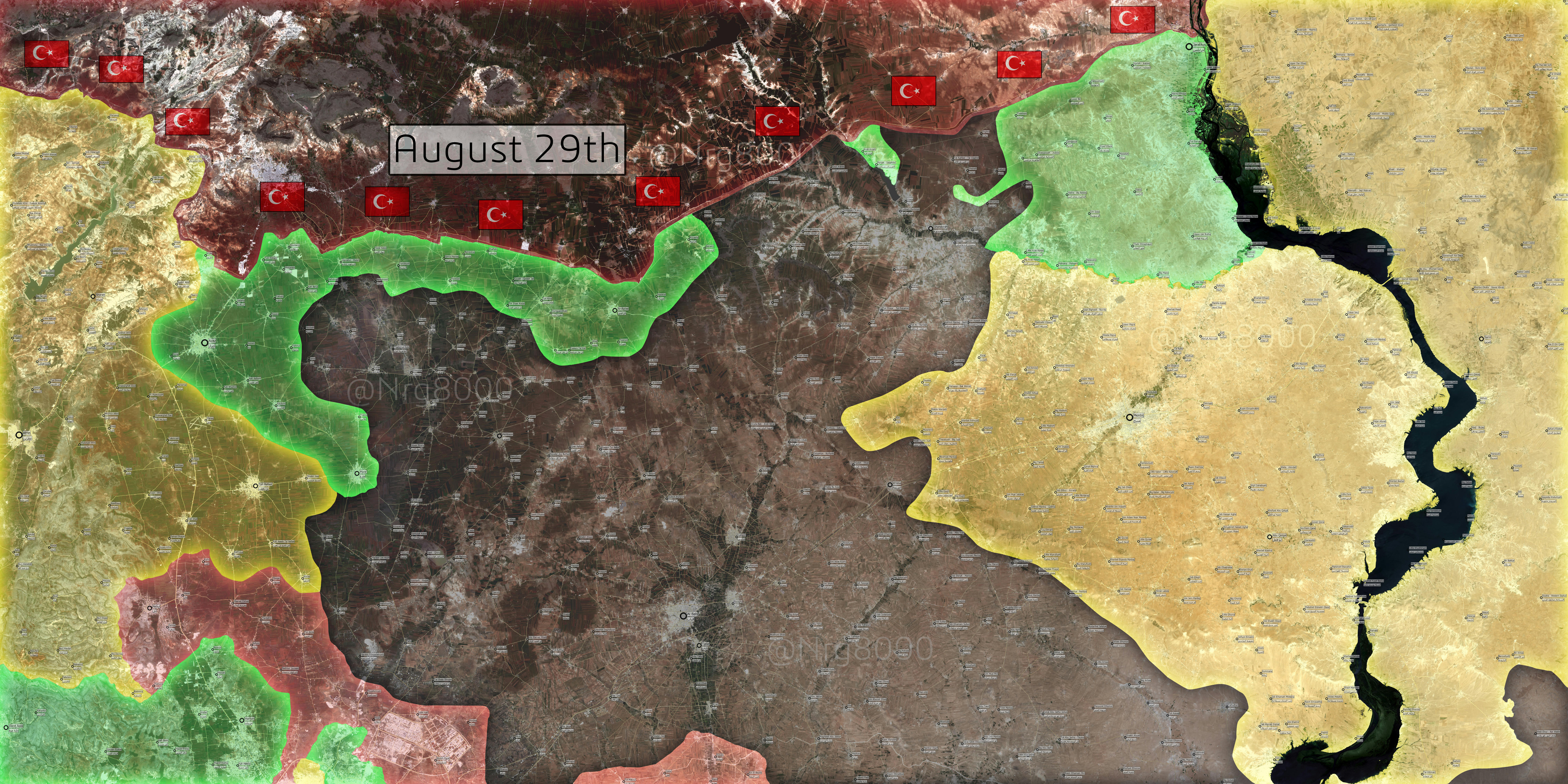
Turkey is now directly fighting in the civil war; e.g. Katlejah was captured by Turkey and the FSA https://www.reddit.com/r/syriancivilwar/comments/4zbxpd/katlejah_west_of_jarablus_captured_by_turkey_fsa/
As a result, I think Turkey should be added to the module key, which currently shows the five factions Government, Opposition, SDF, JFS, and IS. And the villages near Jarabulus which are currently displayed as solid Opposition control should be shown as being under joint Turkey-Opposition control.
I didn't want to add this, seeing as it's such a major change and I've never edited a module before, but does anyone else think Turkey should be added and/or feel like adding them?
Another question is, which color should be used for Turkey? It needs to be something distinctive. A shade of blue, orange, pink, or purple might work? Of those options, I prefer purple; however, if purple is used, then the existing purple used for government-opposition truces would need to be changed (perhaps to orange). Chessrat (talk, contributions) 11:52, 24 August 2016 (UTC)
- Update: I've worked out how to add Turkey to the module (a dark green color is the default for Turkey). As I doubt there will be any objections to this, I'll change villages near Jarabulus to Turkey-Opposition shared control. Chessrat (talk, contributions) 13:02, 24 August 2016 (UTC)
- This is wrong. There is no color for Russia . There is no seperate color for US/UK?Frensh forces fighting with SFD ? Why is Turkey different . I say NO NEW COLOR FOR TURKEY Helmy1453 (talk) 13:12, 24 August 2016 (UTC)
- That's a good point, but I think the difference is that the intervention of the US has been limited to airstrikes / training. Same with Russia. On the other hand, Turkey is leading this operation on the ground; Turkish tanks are present in Syria. It's not really accurate to say that the villages near Jarabulus are solely under opposition control; joint opposition and Turkish control is a more accurate description. So I think a new color for Turkey is appropriate, although it would be good to get some more opinions on this matter. Chessrat (talk, contributions) 13:57, 24 August 2016 (UTC)
- Wrong starts lead to wrong conclusion. We all saw the American and british troops on the ground fighting in Minbij. some of them even KIA . and we remember the photos of russian sodgers storming Salma and Palemero. of course no mentioning Iranian Army which most propably have more sodgers in Syria than in Iran LOL. Helmy1453 (talk) 14:44, 24 August 2016 (UTC)
- Regarding US and British troops - there is no dominant role for those (if any) so far on the ground. Russian troops are present in limited numbers across Syria and personally i support adding a distinct color for Russian bases. Regarding Iran - no official Iranian forces fight in Syria, but rather mercenary militias and military advisors, so it is not the same case as Turkish Army fighting openly in Jarabulus.GreyShark (dibra) 15:42, 24 August 2016 (UTC)
- (dibra) Ur comment is another level of Ignorence. the Iranian army presence as fighting groups (full units) is official and anounced by official state both iranian and Syrian . Same as russian . US support is also official but what is the definintion of dominent? can SFD advance for 1 miter or even hold ground without US support? Helmy1453 (talk) 17:23, 24 August 2016 (UTC)
- That's a good point, but I think the difference is that the intervention of the US has been limited to airstrikes / training. Same with Russia. On the other hand, Turkey is leading this operation on the ground; Turkish tanks are present in Syria. It's not really accurate to say that the villages near Jarabulus are solely under opposition control; joint opposition and Turkish control is a more accurate description. So I think a new color for Turkey is appropriate, although it would be good to get some more opinions on this matter. Chessrat (talk, contributions) 13:57, 24 August 2016 (UTC)
- This is wrong. There is no color for Russia . There is no seperate color for US/UK?Frensh forces fighting with SFD ? Why is Turkey different . I say NO NEW COLOR FOR TURKEY Helmy1453 (talk) 13:12, 24 August 2016 (UTC)
- Comment - as mentioned by user:Chessrat, dark green stands for Turkey as default. In my opinion we can add Turkey as their forces have a dominant role in Jarabulus country-side as of today. It will also have no trouble at the template:Middle East conflicts detailed map, where Turkish forces are already shown beyond the Syria's northern border.GreyShark (dibra) 15:42, 24 August 2016 (UTC)
I think the colour of Turkey must be changed. It is easily whirled with grey. When the colours green and dark green are in one circle, it can be thought as that area is controlled by FSA and Jihadist group. So maybe the colour of Turkey can be changed from dark green to blue or dark blue. Beşiktaşlı aşık (talk) 18:44
Editors jumping to conclusions and making colors on thier own . That is not acceptable. HUGE changes like adding color for Turkey is NOT OK unless agreed upon it in the talk page, and If done all red dots should be switched to stable mix control Govermnet -Iran_Hizbollah-Iraqi-Iarn which would make this page a joke. keep reasanbale. Helmy1453 (talk) 18:32, 24 August 2016 (UTC)
Terrible idea. Color for Turkey should absolutely NOT be added. Turkey offers support in the shape of initial tanks and shelling. Actual controle remains under syrian rebels. If color is added for Turkey, then color must be added for Iran because they have thousands of confirmed troops and advisers offering support to SAA. Color should be added for UK and US because they have special forces on the ground in armoured vehicles through out northeast Syria. Not to mention color for all parties involved in offering air support across Syria which is arguably much more important than any other kind of ground support. In other words color marking is for who is in controle, not who offered support in capturing that area. There is no clear objective way to tell current level of turkish support from support offered by other foreign forces. Only if Turkey stations large numbers permanently in the area which is not the case. We are talking about a dozen tanks and some special forces. Not much more than US/UK special force involvement. Mozad655 (talk) 20:52, 24 August 2016 (UTC)
- The Turks are the ones in control of the area surrounding Jarabalus, not the rebels. The rebels there are Turkish auxiliary forces, trained and maintained by turkey. The Turkish government has been pouring more troops into the area, and has stated it will eventually build up its forces up to 15,000. [[13]]XavierGreen (talk) 13:47, 25 August 2016 (UTC)
- There is no evidence that turks are in controle of Jarablus or surrounding area. Turks offer support to rebels who are in controle. Rebels are officially syrian rebels from FSA. There is no evidence that they are "Turkish auxilliary forces" or any other conspiracy. Whether they are trained and maintained by Turkey makes no difference. They are still syrian rebels. Whether or not they will increase turkish forces to 15.000 is to be seen. Changes should not be made based on something that has yet to happen. Your source states there are up to 15.000 syrian rebels in the offensive and 450 turkish millitary involved on the first day, far outweighed by the much larger numbers of Iranian, Russian and Hezbollah troops on the ground in Syria. Bottom line is that support does not equal controle. Syrian rebels are in controle. Otherwise color has to be added for all foreign troops, which has not been done. Special rules do not apply for turkish troops. Mozad655 (talk) 15:53, 25 August 2016 (UTC)
- BBC reports that Turkish ground forces assisted in the taking of Jar. bbc.com/news/word-europe-37184848
- There is no mention of actual control. Control, on this map, has to do with who exercises jurisdiction over a town or area. The article I linked states Turkish forces are preparing to intervene, and ensure the SDF does not push West of the Euphrates. This implioes Turkey has a presence in the area around Jar., currently marked as under opposition control. Marking the area as under opposition-Turkish control only makes sense. Marking them as under opposition control ignores the fact that Turkey sent tanks, APC's, and other ground units to take the area. Was it taken for the opposition? Yes. Is it under opposition control? No. — Preceding unsigned comment added by DaJesuZ (talk • contribs) 17:03, 25 August 2016 (UTC)
- Precense does nost mean controle. Russians, Hezbollah, Iranians and western countries have presence throughout Syria. Are they in controle? Markining it as OPP controle does not ignore the fact that Turkey offered support anymore than marking government held areas as government only, or SDF areas as kurdish only. Was it taken for oppositon? Yes. Is it under opposition controle? Yes. What your saying are all opinions. Not facts. As you said controle has to do with who exercises jurisdisction over an area. Turkey has not claimed any jurisdiction in any of the new areas. Mozad655 (talk) 13:20, 26 August 2016 (UTC)
If Turkey gets its own color, for the sake of objectivity, please also add new colors for Hezbolah/IRGC, Russian airbases and US positions in Kurdish territory. Turkish military should not be treated any different than the other involved foreign military powers. Schluppo (talk) 21:40, 25 August 2016 (UTC)
- I'm not sure adding colors for US, Russian, or Iranian positions would be justified. Iran has no units (officially) involved in the fighting, instead keeping to advisory positions. Russian airbases or ports are not Russian territory, they are Syrian, and Russia has a stated goal of supporting the Syrian regime, and not controlling territory. The US is in the same position as Russia, but supporting the Kurds and rebels. Turkey is a little different; Turkey is invading, and yes, they are supporting opposition fighters, but exercise territorial control within Syria, and are not doing so expressly for the opposition, instead, they're pursuing their own interests in making sure the SDF does not link Kobani with Afrin Canton. They're in this for themselves. DaJesuZ (talk) 03:56, 26 August 2016 (UTC)
Why not just put Turkey as the same colour as the rebels? (Green). They're on the same side, and it's simple. PaulPGwiki (PaulPGwiki) 11:33, 26 August 2016 (UTC)
Iranian units, both advisery and fighting forces have been confirmed for a long time, regardless of official admission by Iran. Like Russia, Turkey has not stated a goal to controle territory either. They want syrian rebels to controle the area just like Russia and regime. Furthermore western countries have ground special forces through out Syria. The notion that Turkey is "invading" with the intention of controling territory on their own, is an oppinion not a fact. All captured territory is officially controled by FSA. Whether they support FSA "expressly for the opposition" or because they have own interests makes no difference what so ever. All foreign forces are pursuing own interests in Syria and Turkey is no exception. People who want a color for Turkey are clearly biased against Turkey since they perceive this as an invasion rather than a support similar to that of other foreign forces. As there is a high level of disagreement color should not be added. Mozad655 (talk) 13:12, 26 August 2016 (UTC)
Hezbollah officially has thousands of troops in Syria fighting on regime side. Should we add Hezbollah color? Exact same situation as Turkish role. Mozad655 (talk) 15:12, 26 August 2016 (UTC)
Pro-Russian source (Anti-Turkey, Anti-YPG) Following heavy bombardment of Jarabulus (a total of 63 targets were fired at 224 times in the first hours) and a series of air strikes involving aircraft from the U.S.-led international coalition, Syrian Free Army (FSA) troops were able to enter the city and take it under control in a matter of hours. Turkey insists that what is happening cannot be considered to be a ground operation: The task is to open a corridor for the armed forces of the moderate Syrian opposition for cleansing Jarabulus from terrorists. http://rbth.com/international/2016/08/26/turkey-has-gone-further-than-promised-in-syria-says-moscow_624453 Vissar2g (talk) 16:28, 26 August 2016 (UTC)
I'm definitely against this. Turkey's role is no different from the roles played by Hezbollah, Russia, the US and Iran. They are supporting one side, not taking territory for themselves. They're only intervening to put the FSA and related groups in control so the Kurds don't seize the whole border. After that is accomplished, they'll likely leave. The fact that the rebels are Turkish-trained doesn't make one bit of difference. All sides in this war have received training from an outside power. Syrian government troops have been trained by Russia, China and Iran, rebels have been trained by the US, Britain, Jordan, and already by Turkey before (there are reasons why the region where the rebels are strongest by far is along the Turkish border). Who trains them doesn't make any difference. The only thing that's new here is the presence of Turkish troops on Syrian soil. But their actual role hasn't changed. Their objective is to support the rebels, not to control territory themselves. Kawada Kira (talk) 22:23, 26 August 2016 (UTC)
- Comment - some user edited the map on the basis of fictional consensus "reached at the talk page", but... there is no consensus:
- 5 support separate color for Turkey:
- Two users support dark green for Turkey Chessrat, GreyShark
- One user proposed blue for Turkey Beşiktaşlı aşık
- Two users support any separate color for Turkey XavierGreen, DaJesuZ
- 5 users oppose separate color for Turkey
- four users oppose any color for Turkey Kawada Kira, Mozad655, Helmy1453, Vissar2g
- One user proposed using lime color for Turkey (same as rebels) PaulPGwiki
- Neutral / conditional (one)
- One - add Turkey under condition that Russia, Iran, US and Hezbollah are added Schluppo
- 5 support separate color for Turkey:
- So far for now.GreyShark (dibra) 21:17, 28 August 2016 (UTC)
7 users oppose. At least wait for majority of editors to support your viewpoint before changing status quo.
Can we stop this nonsense of adding new colors! Everyone knows that there are four sides of this war, we use Red for Regime, Hizbullah, Iranian Quds force and Iraqi militias, Black for ISIL, Yellow For all SDF factions and Assyrian militias, but when it comes to rebel we use Green and Grey, and now we are adding dark green for Turkish troops supporting rebels although we didn't add any color for collation special forces supporting SDF! as for the Dark green we should remove it because it makes no sense to add it for special forces. as for the grey for JFS we should remove it because JFS is present in many other areas marked as green. and almost all areas marked with grey have presence of other rebel factions. almost 95% of map makers use only 4 colors so why should Wikipedia be different? 3bdulelah (talk) 18:48, 27 August 2016 (UTC)
Grey stays, basically Al Nusra (Jabhat Sham) has a tottaly different ideology than FSA, Ahrar, etc, they reject any political solution, fight against other Rebel groups, etc etc. Many problems. While yes the person who added the Turkish color should be banned emidately. Iran and Iraq supported accounts braging about how they have 20k soldiers in Syria, while Turkey entered Syria with 5 tanks and suddenly they control 50% of the nearly taken teritories around Jarabulus, lolx2. DuckZz (talk) 22:37, 27 August 2016 (UTC)''
Also, it's unlikely that the other colors will be added as we had that discussion before. So the opinion could also be 5/8, depending on one's interpretation.
Vissar2g (talk) 21:29, 28 August 2016 (UTC)
- Add me to the oppose color when it comes to showing Turkey on the map. The lime green is just simpler. Pbfreespace3 (talk) 23:10, 28 August 2016 (UTC)
Turkey has not entered a war through its incursion into northern Syria and has no intention of becoming a permanent power there, broadcaster NTV cited Deputy Prime Minister Numan Kurtulmus as saying on Monday.
"Turkey is not an occupying country. Turkey is not entering a war," NTV cited Kurtulmus as telling reporters in Istanbul: http://www.reuters.com/article/us-mideast-crisis-turkey-dypm-idUSKCN114196 Vissar2g (talk) 17:46, 29 August 2016 (UTC)
Jund al-Aqsa gains in northern Hama governorate
There are news from today that the al-Qaeda branch Jund al-Aqsa conquered several towns and villages in northern Hama governorate today. These gains were already shown on the map by other users. Only - why exactly are they green? They are not part of any moderate alliance, at least if their Wiki-article is true. Of course, there are not part of al-Nusra anymore, but they are by far closer to them than to any other moderate rebel group. Since they criticised al-Nusra's fight against the Islamic State, they are even more radical than al-Nusra, so: Mark them grey!--Ermanarich (talk) 17:17, 29 August 2016 (UTC)
[posted shortly later without knowledge of my (Ermanarich) post:]
Wasn't Jund al-Aqsa marked as grey on the map? Cause if it is, the towns captured today, incluiding Halfaya, should be grey-green. Valewonca (talk) 17:19, 29 August 2016 (UTC)
- According to alMasdar [14], the offensive was executed by "jihadist rebels of Jund Al-Aqsa (Al-Qaeda franchise) and their allies from the Free Syrian Army (FSA)", so the villages should probably be half green, half gray. Schluppo (talk) 19:13, 29 August 2016 (UTC)
al-Nusra/Fatah al-Sham/Army of Conquest
Hello editors,
Currently, there is a discussion at Talk:Syrian civil war#al-Nusra Front on map, how to show Islamist rebels on the map in future. The reason for the discussion is the renaming of the al-Nusra Front to Jabhat Fatah al-Sham some weeks ago. On the map's description (but not here at the Template), Jabhat Fatah al-Sham is still called al-Nusra. In the discussion, another position became subject of discussion: The White colour could be changed to represent the Army of Conquest instead of Fatah al-Sham. With this, the map would be able to show the range of Islamist factions in Syria even more exact, since the Army of Conquest is a quite homogeneous alliance.
Since many of the editors know the situation in the Syrian Civil War quite well and may even be called experts, I'd invite you to take part at the discussion over there.
Regards, Ermanarich (talk) 16:59, 20 August 2016 (UTC)
- So far, it looks like the "Army of Conquest" option is winning. Pbfreespace3 (talk) 17:48, 22 August 2016 (UTC)
- Prompting more people to express their opinions on this. We are considering making the change listed above, but I want more of a consensus before we do. Pbfreespace3 (talk) 00:06, 28 August 2016 (UTC)
- Pleas stop this nonsense, JFS and JaF is present in many other areas marked as green. and almost all areas marked with grey have presence of other rebel factions. almost 95% of map makers use only 4 colors so why should Wikipedia be different? difference in Ideology doesn't mean they should be given different colors, with regime u can find Shia groups like Hezbollah and Baathist groups. Why only the rebel side is being divided like this? 3bdulelah (talk) 01:45, 28 August 2016 (UTC)
- Army of Conquest =/= Jabhat Fatah al-Sham. The groups are not one in the same, but JAF does make up the largest group that makes up the coalition. Groups holding a defined territory should be named accordingly, or we're going to need to expand the white area, and place all areas under any group part of the Army of Conquest in that area. 3bdulelah, if you honestly think the former al-Nusra front and the Free Syrian Army should be grouped in together, you must not know much about either group. Jabhat Fatah wants an Islamic emirate, and wants to control the country, and openly fights with the FSA, as well as other opposition groups. This has gone on for a while. This has been interpreted as them pursuing their own ambitions, regardless of them sharing common enemies in the Syrian regime, Hezbollah, or Islamic State. DaJesuZ (talk) 01:57, 28 August 2016 (UTC)
- Before challenging my knowledge on this issue u need to know that I'm following this war since the very beginning, You need to know that in every town where JFS is present there are FSA factions too, internal conflict happened b/w other groups too not only Nusra Vs FSA. 3bdulelah (talk) 02:08, 28 August 2016 (UTC)
- That's right but Nusra actually control the grey towns while the FSA are merely guests. There are towns under FSA control but Nusra is hosted there and vice versa. This map is about the control of various factions, not the mere presence of them. Editor abcdef (talk) 10:41, 30 August 2016 (UTC)
Awn Al Dadat still under SDF control
Awn Al Dadat is south of Sajur river and under SDF control and until now FSA did not crossed the Sajur river, the FSA just took the villages north of Sajur river there is no source or contrary claims by FSA that claims that they crossed Sajur and took over Awn Al Dadat, its still under SDF.
http://syria.liveuamap.com/en/2016/30-august-a-truce-was-agreed-between-fsa-and-ypg-in-the-west
http://tr.hawarnews.com/cerablus-askeri-meclisi-guclerini-sacurun-guneyine-cekti/
http://viettimes.vn/quoc-phong/ngay-thu-6-linh-tho-tien-vao-syria-giao-tranh-dam-mau-va-hon-loan-74119.html --Alan Genco (talk) 15:41, 30 August 2016 (UTC)
Turkish invasion
It looks like all news agency agree´s, and the Turkish government too, but there are one "small irreducible village of Gaul´s" in this all cyberspace and reality that disagree´s...that village is called Wikipedia!!! Because of that I make only one question, if you disagree with that, why you have made an article with that called Operation Euphrates Shield or Jarabulus offensive (2016)? It´s simple if you backup a state version that nothing is happening and that the Free Syrian Army are the only in that offensive...why other article said exactly the opposite and backup that version? You know...it is interesting to see how many editors sell themselves to the interests of the "invaders" and loose all the neutrality that they announce but not practice!!! Geosapiens (talk) 14:57, 30 August 2016 (UTC)
What exactly are you complaining about? Mozad655 (talk) 22:25, 30 August 2016 (UTC)
New front in Jarablus by lake Sajur?
According to some maps (see below) the villages of Arab Azah and Fursan are under FSA controle. Can anyone confirm this? Mozad655 (talk) 00:05, 31 August 2016 (UTC)
http://www.mediafire.com/convkey/f827/ktkg8e0g8kedlgbzg.jpg
http://i0.wp.com/newsmap.pl/wp-content/uploads/2016/08/Northern-Aleppo-military-situation-August-30-2016.png?fit=2338%2C1653 https://www.omrandirasat.org/images/M.C.E.UN.P/Territorial%20Control%20Map%20-%20Aleppo%20-%20%20Active%20Fronts%20-%20August%2029%20-%202016.pdf
Sajur Dam
Sajur Dam (Directly south to Fursan village on our map) should be added on the map since it seems that the Sajur lake is one of the main objectives of the FSA/Turkish Special Forces right now on the Jarabulus front. Link to the dam location on Wikimapia: http://wikimapia.org/#lang=es&lat=36.697466&lon=37.725849&z=13&m=b&show=/30502607/Sajur-Dam Valewonca (talk) 17:25, 31 August 2016 (UTC)
Situation in Northen Hama
Info mainly from Twitter sources, not reliable!
Pro-rebel sources report about a VBIED detonation (most likely in a military checkpoint) and clashes at the outskirts of Taybat al-Imam (here, here and here)
Pro-gov sources, incluiding Al-Masdar report that SAA recaptured Al-Buwaydah, wich doesn't necessarily denies previous pro-rebel claims (here, here and here)
Should wait for more reliable sources to confirm, I suggest puting enemy pressure in both towns until then. Valewonca (talk) 00:08, 30 August 2016 (UTC)
- Bateesh, Nasiriyah, Khattab and Khirbet al Hujamah reported by Pro-Gov source alMasdar to be taken by rebels: here and here. Schluppo (talk) 00:10, 31 August 2016 (UTC)
- Khattab village supposedly retaken by SAA here; clashes ongoing at the northern outskirts of Khattab village. Schluppo (talk) 00:22, 31 August 2016 (UTC)
Jund Al-Aqsa captures Souran in northern Hama https://www.almasdarnews.com/article/jund-al-aqsa-captures-souran-northern-hama/ — Preceding unsigned comment added by 89.167.129.54 (talk) 19:47, 31 August 2016 (UTC)
Northern Hama
The rebel offensive in northern Hama is under way, and this map is not accurate anymore:
- https://www.almasdarnews.com/article/jund-al-aqsa-sets-sight-alawi-town-northern-hama/ (green half-circle north of Ma'an in Hama)
- http://www.todayonline.com/world/syrian-rebels-advance-further-toward-government-held-hama-city-monitor-rebels (rebels take Souran)
- Second source for Souran: https://www.almasdarnews.com/article/jund-al-aqsa-captures-souran-northern-hama/
- https://www.almasdarnews.com/article/jihadist-rebels-seize-two-villages-northern-hama/ (Al-Nasiriyah between Tayyibat al-Imam and Souran to green)
Maybe it's also reasonable to put a half-green circle north of Khattab, since rebels are very close to that town after taking Al-Nasiriyah. There have been reports of fighting at the edges of the town. — Preceding unsigned comment added by 84.24.43.183 (talk) 18:34, 31 August 2016 (UTC)
- According to Qasioun, rebels take Tall Bizam (west of Ma'an) and al Tarabia Checkpoint (south of Helfaya) here. Is it a reliable source? Schluppo (talk) 20:23, 31 August 2016 (UTC)
"Ramouseh Military Complex" icon completely obstructing opening of rebel area of Aleppo city
This is in relation with my undoing of the edit 15:07, 31 August 2016 (UTC) by Mehmedsons. Sorry but i am removing the "Ramouseh Military Complex" icon. You will have to put it directly on the aleppo city SVG map. The big contested icon is completely obstructing the opening of the rebel-controlled area of Aleppo city. It gives the impression that the whole opening to the outside world is contested and that there is a major gov assault that risks re-establishing the siege. It is not the case. As I indicated before, if you read the source carefully, it says that gov just retook something (small) jihadists took a day before. So no need for change on our map. It is "Not really noteworthy" as Jonathan Richer noted in comments section. So our viewers should be able to see that the opening of the rebel-controlled area of Aleppo city is still there since the rebels still solidly control the "Aleppo Artillery Faculty". So this tiny green area needs to stay visible. Tradediatalk 22:12, 31 August 2016 (UTC)
Sorry, but I reinstated the icon before reading the post. Nevertheless, the situation is changed with the conquest from SAA of the technical college and the attack in the Armament school https://www.almasdarnews.com/article/syrian-army-hezbollah-enter-armament-school-southern-aleppo/. The rebels control only part of the complex. Furthermore, the rebels controlled corridor is almost closed and that should be marked on the map. If there is no consensus on it, I'll revert the change.Paolowalter (talk) 17:45, 1 September 2016 (UTC)
Clashes near Tel Abyad and Ayn Issa
2 FSA factions in the SDF have defected and clashes between them and the YPG have broken out in the villages near Tel Abyad and west of Ayn Issa. The option is to mark these villages as been contested between green and yellow. Editor abcdef (talk) 10:30, 2 September 2016 (UTC)
Acc. to al-Masdar, YPG has been expelled from 5 villages. So at the very least they should be marked as contested. Liwa al-Tahrir would then qualify as opposition (green color). Mozad655 (talk) 15:31, 2 September 2016 (UTC) https://www.almasdarnews.com/article/arab-group-leaves-kurdish-ypg-led-syrian-democratic-forces/
- No. Masdar said the rebel brigade in question said it seized the villages. Also, no other source mentions it. When pro-YPG sources start mentioning the actual towns, then we will know something is up. For now, we simply do not have enough information. If these sources show up, then I'd love for the villages to be changed. Hell, if you want to add a presence icon right now, I'm fine with that. Pbfreespace3 (talk) 20:37, 2 September 2016 (UTC)
- I get your point and agree but normal editing procedure around here is that its okay to edit if someone is claiming. In fact almost all sources used are just media saying that or this side said so and so. Media rarely claim something themselves because if it turns out wrong then they'll lose credibility. Correct procedure is to wait for opposite side to confirm but that doesn't seem to be normal procedure around here and I see no reason why we should make exceptions now. Mozad655 (talk) 22:55, 2 September 2016 (UTC)
- Liwa Ahrar al-Raqqa claimed to have expelled the YPG from al-Qadriyah, al-Hamdanat, Kardushan, al-Duraybiyah, and Abo Tabat. Editor abcdef (talk) 23:36, 2 September 2016 (UTC)
As it turns out, they haven't. They actually denied it. The source is in the edit history. Pbfreespace3 (talk) 23:11, 3 September 2016 (UTC)
Cleanup in Jarablus area
Alot of bias and propganda in edits concerning newly captured Jarablus area. Specifically pro-SDF edits. High use of personal twitter accounts. They should not be allowed even if the person being quoted is "on the other side" and "admitting" a loss. Surely only official, non-partisan and english-speaking news outlets should be allowed. SDF did not capture 20-40km of heavily guarded land all of a sudden in south of Jarablus. Turkey would not clear ISIS without syrian rebels filling in and leaving area clear for SDF. Lets think for a moment before spreading propganda. Reality is truth and there is no reason lying about it when its not real. It doesn't change the situation on the ground for whoever a person might side with in this conflict. Mozad655 (talk) 21:32, 24 August 2016 (UTC)
- Reliable source reporting on the situation: https://www.almasdarnews.com/article/turkish-backed-rebels-fight-us-backed-rebels-aleppo/ Schluppo (talk) 02:21, 25 August 2016 (UTC)
- That is not a reliable source as its not neutral. Its a syrian regime propganda news outlet. Here's another tweet from them https://twitter.com/TheArabSource/status/768486265402503168?lang=da deeming the turkish involvement "illegal". On their facebook you can see they are affiliated with official syrian regime news outlets. They side with the regime and have a direct interest in supporting PKK's position in Jarablus. 87.60.188.96 (talk) 10:56, 25 August 2016 (UTC)
- AlMasdar is of course not neutral but it was decided again and again that alMasdar is a reliable source for this map and can be (carefully) used to edit this map, when articles mention names of locations. Schluppo (talk) 21:21, 25 August 2016 (UTC)
- I woudn't consider a non-neutral source reliable. A source that is not neutral is naturally biased. The decision that it is "reliable" must be among proponents only. Might aswell quote official syrian state television. Mozad655 (talk) 20:43, 26 August 2016 (UTC)
- What you would and what you wouldnt consider RS is not the topic here. Al Masdar has been extensively used throughout the whole Syrian civil war pages per consensus with no issue raised at board. EllsworthSK (talk) 11:38, 27 August 2016 (UTC)
- What is and isn't reliable source is precisely the subject here. I see an issue when it is used to back pro-regime gains. Rule 1 for editing this map clearly says "b) A well-known source that does not have a reputation for neutral (not biased) territorial control coverage, can be used (is deemed reliable) only for edits that are unfavorable to the side it prefers (favorable to the side it opposes).". Al-Masdar is not a neutral by your own admission yet is used for all kinds of edits. Its a big problem regardless of whether noone has questioned this before or not. Mozad655 (talk) 16:03, 31 August 2016 (UTC)
- AlMasdar is broadcasting syria news for years and none of its news denied by other sources ,its not important willingness of anybody till they not broadcast false news in favor of their willingness , so we can call sources reliable and natural till their news can be trusted .P.rafati (talk) 05:52, 6 September 2016 (UTC)
- What is and isn't reliable source is precisely the subject here. I see an issue when it is used to back pro-regime gains. Rule 1 for editing this map clearly says "b) A well-known source that does not have a reputation for neutral (not biased) territorial control coverage, can be used (is deemed reliable) only for edits that are unfavorable to the side it prefers (favorable to the side it opposes).". Al-Masdar is not a neutral by your own admission yet is used for all kinds of edits. Its a big problem regardless of whether noone has questioned this before or not. Mozad655 (talk) 16:03, 31 August 2016 (UTC)
- What you would and what you wouldnt consider RS is not the topic here. Al Masdar has been extensively used throughout the whole Syrian civil war pages per consensus with no issue raised at board. EllsworthSK (talk) 11:38, 27 August 2016 (UTC)
- I woudn't consider a non-neutral source reliable. A source that is not neutral is naturally biased. The decision that it is "reliable" must be among proponents only. Might aswell quote official syrian state television. Mozad655 (talk) 20:43, 26 August 2016 (UTC)
- AlMasdar is of course not neutral but it was decided again and again that alMasdar is a reliable source for this map and can be (carefully) used to edit this map, when articles mention names of locations. Schluppo (talk) 21:21, 25 August 2016 (UTC)
- That is not a reliable source as its not neutral. Its a syrian regime propganda news outlet. Here's another tweet from them https://twitter.com/TheArabSource/status/768486265402503168?lang=da deeming the turkish involvement "illegal". On their facebook you can see they are affiliated with official syrian regime news outlets. They side with the regime and have a direct interest in supporting PKK's position in Jarablus. 87.60.188.96 (talk) 10:56, 25 August 2016 (UTC)
Maarat al-Nu'man
After the Second Battle of Maarat al-Nu'man in March 2016 al-Nusra has taken full control over Maarat al-Nu'man. This was the case on the detailed map for a while but for some reason someone changed it to half-green half-grey recently. What's the explanation for this change? Editor abcdef (talk) 03:13, 4 September 2016 (UTC)
- Part of the reason why this is, is that pro-FSA, anti-Nusra protestors are allowed to freely protest on the streets every day for months now. If I am not mistaken, there is also some kind of FSA division present in the city. They may be locked up, I need to do more research. Pbfreespace3 (talk) 19:06, 5 September 2016 (UTC)
- There are some FSA elements present in the city. However, the few of those who were not captured or have fled are currently unarmed and unable to exert any control over the area. Sources indicate that what's left of the 13th Division in the city got all of their weapons stolen since March 2016. Editor abcdef (talk) 07:21, 6 September 2016 (UTC)
Jarabulus
The Free Syrian Army withdrawn from their bases in the city Jarablus and handed over control to the new local council where dominated the ethnic Turkmen.link Mehmedsons (talk) 18:50, 6 September 2016 (UTC)
- This wouldn't really change the colours of the dots though. All rebel groups from the FSA to Ahrar al-Sham are lumped in as green, so Turkmen wouldn't be any different. Editor abcdef (talk) 02:21, 7 September 2016 (UTC)
Huwaysas
According to Al-Masdar (hereand here) IS has been trying to capture this village north west of Palmyra, wich means that it's under government control, not under IS control like in our map. It should be changed to red whit a black semicircle. Valewonca (talk) 03:13, 3 September 2016 (UTC)
- Done. Pbfreespace3 (talk) 23:12, 3 September 2016 (UTC)
- Huwaysas controlled the pro-government forces according the local soure.link Mehmedsons (talk) 08:21, 7 September 2016 (UTC)
Color of Joint military forces of turkey
Turkish army with tanks and armed forces crossed the border alongside turkish backed militias in northern Jarablus and captured several areas, so I recommend to use different color for this joint military forces to show the difference for e.g violet or purple .P.rafati (talk) 05:31, 6 September 2016 (UTC)
- This was already discussed at length and no consensus for adding a new colour for Turkey was achieved. In my personal opinion, if Turkey gets a new colour, at least IRGC/Hezbollah has to get a new colour as well. This would seriously complicate the map. Schluppo (talk) 19:16, 6 September 2016 (UTC)
- it s not clear where and how long IRGC/Hezbollah take control of some areas and it makes impossible to use a new color but the situation about turkish army is really clear ,they crossed the boarder and held some territories .so I recommend a map like this pro-jihadists map : http://syria.liveuamap.com P.rafati (talk) 07:45, 8 September 2016 (UTC)
Jarba Eastern Ghouta
The detailed map of the eastern Ghouta shows the village of Jarba under rebel control while several maps like those of PetoLucem place it under gov control since long (I know that PetoLucem is pro gov but his maps are rather reliable), can someone clarify this ?82.233.227.191 (talk) 13:31, 5 September 2016 (UTC)
I remember this case before. Back in July when SAA captured Maydaa and Bahariyah, Jarba was changed to government held but there where no reports about it, and taking in consideration that Jarba is an important town in the region and no one said anything it probably was an exaggeration or a mistake; it was changed back to rebel held some time later Valewonca (talk) 16:01, 5 September 2016 (UTC)
So we have to find pro rebel report or maps to fix it — Preceding unsigned comment added by 37.164.128.15 (talk) 14:29, 8 September 2016 (UTC)
Tel Sawwan, east Ghouta
This is in relation with my undoing of the edit 15:47, 8 September 2016 (UTC) by Mehmedsons. SOHR from sep 8 says: Tel Sawwan TOWN is contested (استمرار معارك الكر والفر داخل بلدة تل الصوان). Also, you put "Tel Sawwan HILL" in a place where wikimapia says “Tall Sawwan FARMS”, so I am removing it since we now have the town marked. Tradediatalk 09:39, 9 September 2016 (UTC)
The map breaks my screen

The map needs to be scaled to the page somehow. Here is a screenshot of what it looks like for me.
You folks are brilliant with Lua; you must know some way to make this work. :-) — Gorthian (talk) 17:49, 10 September 2016 (UTC) {{ping}} me with any replies.
- No! No scaling to the screen, please. It is fine as it is. Scaling would make the details too small to be visible. Esn (talk) 19:36, 10 September 2016 (UTC)
Jund Aqsa
What about Jund Aqsa? They are ISIS linked but not ISIS. They are JaF linked but not JaF, can we add a another collor for him? They're a weird group, not even rebel. Beshogur (talk) 22:42, 10 September 2016 (UTC)
- The JaF option hasn't been implemented yet so white and blue are still just al-Qaeda affiliates. Jund al-Aqsa is one of them and could be even more AQ than JFS itself. Editor abcdef (talk) 22:59, 10 September 2016 (UTC)
- I agree here. Grey/white is the best colour to represent them. — Preceding unsigned comment added by Ermanarich (talk • contribs) 23:00, 10 September 2016 (UTC)
- Based on talk page consensus, I will make this change. If anyone objects, please say so here. Pbfreespace3 (talk) 00:37, 12 September 2016 (UTC)
- I agree here. Grey/white is the best colour to represent them. — Preceding unsigned comment added by Ermanarich (talk • contribs) 23:00, 10 September 2016 (UTC)
Links that need disambiguating
I was going to edit the map module to disambiguate several links, but after a couple of hours and the third time my app crashed when I tried to copy and save the text I'd altered, I gave up. I'll leave it to those of you who are used to it to implement these changes. I'll list the links here, and my suggestions for replacement links, and the lat/long of each location. I am NOT sure that the locations of the towns that have articles are the correct ones. I checked the two Marrans; the wrong one was linked to Maran, Syria. But checking was so time-consuming that I decided not to check any others. Anyway, here's the list:
| Original link | Corrected link | Location |
|---|---|---|
| Islamic State | Islamic State of Iraq and the Levant | In the map legend |
| Al Qusayr | Al Qusayr, Syria | lat = 36.100, long = 37.741 |
| Maryamin | Maryamin, Hama | lat = 34.887, long = 36.415 |
| Kadin | Kadin, Syria | lat = 35.689, long = 36.178 |
| Marran | Maran, Syria | lat = 36.274, long = 37.351 |
| Marran, Syria | Marran, Hama | lat = 35.732, long = 36.255 |
| Izz ad-Din | Izz al-Din, Syria | lat = 34.948, long = 36.917 |
| Balaban | Balaban, Syria | lat = 36.687, long = 37.957 |
| Al-Sukhnah#civilwar | Al-Sukhnah, Syria | lat = 34.887, long = 38.871 |
I kept the original piped text if there was any, and piped the original name if there wasn't a pipe originally. The red links, of course, can be changed to whatever works best.
This map is an amazing work of coordination; kudos to all of you for making it work. But I will make one plea: when you throw brackets around a name or word, please be sure that link goes where it should. Keep up the good work! — Gorthian (talk) 03:55, 11 September 2016 (UTC)
Khan Tuman info
Khan Tuman in the information chart below the map needs to be updated, it says it's still under government control and has the SAA flag on it. I don't do it myself cause I am not familiar whit the scrip and I don't to ruin it: https://en.wikipedia.org/wiki/Cities_and_towns_during_the_Syrian_Civil_War#Khan_Tuman Valewonca (talk) 19:39, 11 September 2016 (UTC)
- The "information chart below the map" is obsolete and is in the process of being merged into other articles. It is hopelessly outdated and no one looks at it or updates it anymore, so I wouldn’t worry about it. Information on towns (description of control & sources) can be found by clicking on the town dot on the map. Notice the caption of the map which says: "Hold cursor over location to display name; click to go to sources &/or status description (if available, the cursor will show as
 ; if not, it will show as
  )." As you can see, the correct “control information” is in the article about the town: Khan Tuman. Tradediatalk 10:58, 12 September 2016 (UTC)
Al-Nukbhat Bridge presence in southern Hasakah
Al-Nukbhat Bridge militias have all defected from the FSA and joined the SDF. The little green box of dots must be coloured yellow, not green. Jewnited (talk) 20:17, 18 September 2016 (UTC)
- Since the FSA is just a loose umbrella term. The Elite Brigade didn't "defect" from "the" FSA, but has always been a FSA group, SDF or not. Editor abcdef (talk) 06:03, 19 September 2016 (UTC)
- http://rudaw.net/english/middleeast/syria/13092016 The map legend states that yellow represents the Syrian Democratic Forces. Since the al-Nukhbat Brigade have all joined the SDF, the designation of the presence icon as green is inaccurate and needs to be changed to yellow. If we make it such that FSA groups with the SDF are still designated as main rebels then large parts of Rojava controlled by JaT and other Arab groups would have to be changed to green. Therefore at the very least, for consistency the icon needs to be changed to yellow.109.176.231.105 (talk) 15:53, 24 September 2016 (UTC)
Tell Qarah
https://en.wikipedia.org/wiki/Tell_Qarah says (with source) that SDF took over the village on 30 August 2016. Did isis reconquer it? --2A02:908:C30:3680:EDC2:B166:8810:D8D6 (talk) 16:57, 13 September 2016 (UTC)
- Amaq reported that the village was recaptured by ISIL. Beshogur (talk) 11:01, 18 September 2016 (UTC)
- I believe you all know that Amaq can't be used for edits that are favorable to ISIL. Erlbaeko (talk) 08:32, 19 September 2016 (UTC)
- Daesh's Amaq-propagnada bureau can clearly not be used as a source in this situation. --Niele~enwiki (talk) 18:20, 19 September 2016 (UTC)
- Mehmedsons,Niele~enwiki,Erlbaeko These villages were captured by YPG, but then were recaptured as we speak check diffs! and guys dont use wikipedia and pro-kurdish twitter source as a source to change the status or twice the same outdated article from al-masdar that reported the captured of these villages for the first time.Lists129 (talk) 12:41, 21 September 2016 (UTC)
- Lists129 If you have an RS dated later than 30 August 2016, that is saying Tell Qarah is under ISIL control, you should update the wiki-article. Then you can change the color on the map. Erlbaeko (talk) 06:37, 22 September 2016 (UTC)
- Erlbaeko Here diff...you have to pay more attention on the timeline of the template and the events that are made and check diffs instead of making inconsequent reverting.Lists129 (talk) 12:49, 23 September 2016 (UTC)
- They where already updated with new, more recent sources.
- https://twitter.com/MarkMonmonier/status/778090665209131008, https://twitter.com/CivilWarMap/status/778309371478568960, https://twitter.com/KurdRoji/status/779705145496104964, https://twitter.com/UniteKurdistan/status/777890408252764160, https://twitter.com/nighttides/status/778712626595442689, https://twitter.com/KurdisCat/status/778276653785083906,...--Niele~enwiki (talk) 15:36, 24 September 2016 (UTC)
- They where already updated with new, more recent sources.
- Amaq reported that the village was recaptured by ISIL. Beshogur (talk) 11:01, 18 September 2016 (UTC)
- Niele~enwiki you only provided pro-biased and map sources which are against the rules of editing also outdated ones too,so you need to rv yourself.Lists129 (talk) 15:51, 24 September 2016 (UTC)
- Amaq is Daesh his (not neutral) propaganda bureau, while @MarkMonmonier and written statements from @CivilWarMap are neutral objective sources. It's that simple.--Niele~enwiki (talk) 16:10, 24 September 2016 (UTC)
- Niele~enwiki Wrong...Both are map sources @MarkMonmonier pro-kurdish & @CivilWarMap gathers information from other unreliable twitter sources and can not considered neutral,you need to rv yourself.Lists129 (talk) 16:29, 24 September 2016 (UTC)
Opposition retaken, "Handarat"
http://www.bbc.com/news/world-middle-east-37465662 Not sure if this is the city, or the camp, since the camp was reported as taken by the government a couple years ago, with no changes being made to the .svg map for the ongoing fighting. Is Handarat refugee camp the same as the Aleppo suburb? DaJesuZ (talk)| —Preceding undated comment added 12:35, 25 September 2016 (UTC) It's in the suburb, and according masdar news recently conquered by the regime2.122.198.161 (talk) 19:50, 25 September 2016 (UTC)
Fix it please
Some mistakes on the map.
1. Homs city & Rastan enclave: some sourses (example [15]) claims full goverment control over Al-Waer district after the evacuation. I think it need to be coloured red now. Musa al-Hulah − SAA, Al-'Imarah − rebels [16]
2. Eastern Aleppo: Barlehiyah (and its hill), Rasm as Sirhan, Hazarah are still under ISIS control (even on Aleppo battle map on Wiki).
3. Southern Aleppo: Abu Ruwayl was captured by militants this spring (pro-gov map [17]); Khan Touman Ammunition Depot is under JAF control, Gas Storage Facility (east of Ramouseh) too [18].
![[17]](https://syriamaps.files.wordpress.com/2016/04/3.jpg)
4. Western Qalamoun: Tall Ayn Nusur belongs to militants [19][20], presense of ISIS in Jaround Jarajir (but not in Tallat Na'imat) and JFS south of ISIS along the Lebanese border [21].
5. Palmyra & Qaryatayn: Tall SyriaTel east of Qaryatayn is under ISIS control, probably a confusion because of many similar objects through the country (near Palmyra, Ithria etc). Talilah crossroad lost by SAA few month ago, Al-Talila reserve was never captured.
6. Northern Hama: information of recapturing Btaysh village by SAA was incorrect [22].128.71.100.106 (talk) 19:30, 23 September 2016 (UTC)
Afrin canton
Is this a joke ?. Around 1 000 villages added for a region that had 200k population prior to 2011. Todays number even less. DuckZz (talk) 12:40, 25 September 2016 (UTC)
- I have contacted Niele and requested changes to the addition: namely a decrease in size for these villages. I'm sure all of them do exist, but some of them are quite small and need a size reduction. Pbfreespace3 (talk) 17:16, 25 September 2016 (UTC)
- I think most of the villages should be removed, since they're not relevant for now. If Afrin Canton gets invaded, THEN we can add them, but now there's no point in adding hundreds of villages in a region that has stayed calm for the most time. Keeping the bigger towns and the ones near the frontlines should be enough.79.246.2.250 (talk) 12:46, 26 September 2016 (UTC)
Hama
Rebels and Jihadists have advanced in northern Hama. They have taken over the following villages east and souteast of Maan: Qarah, Ras Al-'Ayn, al-Sha’tha and the hill of Bayt al-Aswad. Those should be green-grey.
Source: https://www.almasdarnews.com/article/jihadist-rebels-capture-3-villages-northern-hama/ Source: https://southfront.org/jabhat-al-nusra-joints-us-backed-militants-attacking-government-forces-in-northern-hama/ --84.24.43.183 (talk) 16:57, 27 September 2016 (UTC)
Unsourced edits of openly Pan-Turkism nationalist user:Beshogur
Hi, the previous days, openly Pan-Turkism nationalist user Beshogur (see flag on profile) made several incorrect frontline updates without providing any sources. Both changing villages under SDF/YPG control at frontlines toward pro-Turkish rebels in a case of over-obvious NPOV pushing.
One is the village of Maranaz (http://wikimapia.org/26139085/Maranaz) a village that has been frequently shelled by the Turkish army from the border.
- - Pro-Turk source: ::https://twitter.com/Turkish_Defence/status/699995572556709889
- Other sources:
An other is the 96% ehtnic Kurdish village of Merîn/Ma'arin (http://wikimapia.org/29109359/Merîn) a interlinked double-village with the Yezidi Qestele-village on the steep slopes of Barsaya mountain.
He changed the front-line control of this pvillage twice, both without providing a source for this incorrect front-line change from pro-Kurdish SDF toward pro-Turkish rebels control.
He also duplicated villages around azaz like he did with Kafr Kalbin.
Also without providing any source that there would be 2 Kafr Kalbin around Azaz under Pro-Turkish rebels control on different locations.
He also systematically enlarges villages he claimes are under control of pro-Turkish rebel (like village Tilalayn, http://wikimapia.org/1666361/Tilalayn to a whopping '7', normally only used for towns) and in the meantime he makes SDF-held villages smaller than the minimum used mapsize of 4 normally used for hamlets, while sizes smaller than 4 are nowhere else used.
I find it regrettable that Turkish nationalist racist hate against minorities like Kurds, Armenians,... are getting room on wikipedia and
openly pan-Turkish nationalist users like Beshogur getting room for trying to hide Kurdish of SDF-held villages on this map.
As a neutral Belgian (with only many Turkish and no direct Kurdish friends) believing in the Human rights of all peoples and minorities, I will alway's try to stop such NPOV-based actions with the objective of trying to minimize the existence of minorities that don't fit in a Turkish nationalist view/parallel realities.
Is it possible for an admin to stop this user from making such (unsourced, NPOV) edits on this map and using this map for such ugly objectives.--Niele~enwiki (talk) 20:23, 28 September 2016 (UTC)
- First, stop calling me racist, I'm not. There's nothing wrong with Turkish nationalism and Pan-Turkism. About the villages, I added sources, FSA Sultan Murad claimed that village. Beshogur (talk) 13:41, 29 September 2016 (UTC)
Hama offensive
Jihadist rebels of Jund al-Aqsa and Free Syrian Army brigades have taken over three villages east of Maan and Kubbariyah. We should mark them grey-green. The three villages are in the Al Masdar article in the source.
Source: https://www.almasdarnews.com/article/jihadist-rebels-capture-3-villages-northern-hama/ — Preceding unsigned comment added by 84.24.88.40 (talk) 12:50, 27 September 2016 (UTC)
- Several pro government activists in Twitter reporting that Tulaysiyah (Tleisa on the map) has been captured by rebels/Jund Al-Aqsa minutes ago and probably advancing on Zegbeh; here, here and here. Should wait ultil reliable sources confirm. Valewonca (talk) 17:43, 27 September 2016 (UTC)
On Thursday, rebels gained control over the villages of Khafsin and Karah, http://www.reuters.com/article/us-mideast-crisis-syria-idUSKCN11Z1IY, put khafsin in green ... — Preceding unsigned comment added by 72.37.140.35 (talk) 12:41, 29 September 2016 (UTC)
New info: Qarah and Kafseen near Maan taken over by rebels Source: https://www.almasdarnews.com/article/jihadist-rebels-seize-two-villages-northern-hama-2/ — Preceding unsigned comment added by 84.24.43.183 (talk) 13:43, 29 September 2016 (UTC)
Mark contested areas with markers showing historical progress
This request is forwarded from User:Psubrat2000 on Talk:Islamic State of Iraq and the Levant:
I have a suggestion regarding the "ongoing battle" concept.
I visit this site regularly for the last 18 month, to check-up on the territorial situation. Even though I see the map every couple of days, when there is a new contested area, I cannot tell which side is on the offensive, and which is defending.
Could you update the template to include this information? There is a "(" position, when siege is underway, we could combine the siege and contest concepts to introduce three different kind of contest. 1. Siege, 2.Offensive, 3.Stalemate(which is what the current contested area template seems to represent).
Thank you in advance,
Psubrat2000 (talk) 07:56, 30 September 2016 (UTC)
I think this would be a very meaningful change, but I don't know how difficult it would be for the maintainers to put it into code. Until now I just opted for looking at historical versions of the map that gets copied to Commons and comparing (apparently commons:User:BlueHypercane761 stopped doing this around August and other people have started updating it using different methods). --BurritoBazooka (talk) 02:57, 3 October 2016 (UTC)
Ehtimilat, Dabiq size
Ehtimilat is near 2x bigger then Dabiq, but someone will show Ehtimilat as a small village. Beshogur (talk) 13:40, 29 September 2016 (UTC)
- The sizes are definitely wrong. The 2004 census lists Fan Shamali as having a population of ,1,877 while Sawran, Aleppo Governorate stood at 6,998, yet both have the same size on the map. Ihtaimalat also stood at 6,764. NightShadeAEB (talk) 08:50, 1 October 2016 (UTC)
 Done according to 2004 census and Module:Syrian Civil War detailed map/doc#Dot size guide for cities & towns. Tradediatalk 21:03, 3 October 2016 (UTC)
More links to be disambiguated
These links in the map (probably recently added) need to be disambiguated so that they lead to the correct articles:
Please {{ping}} me if you need to ask anything. Thanks. — Gorthian (talk) 05:17, 1 October 2016 (UTC)
Semi-protected edit request on 6 October 2016 Arima Status
This edit request to Module:Syrian Civil War detailed map has been answered. Set the |answered= or |ans= parameter to no to reactivate your request. |
Considering that no one in the SDF reported losing Arima town back to isis after conquering it last week, and that a recent article from the washingtoninstitute says that they hold it I think it should be changed to yellow on the map to indicate the SDF control over it. [1] 188.251.37.85 (talk) 19:20, 6 October 2016 (UTC)
- Change it, if you can find a reliable source. Once again, maps are not to be used. --Ahmedo Semsurî (talk) 19:24, 6 October 2016 (UTC)
References
Vandalizm by Ahmedo Semsurî
Ahmedo Semsurî said: Don't use opposition sources for opposition gains.
Which sources should I use? Please give me answer.
Admin, please ban this user from this template. The village Aziziya was captured by FSA and confirmed by official accounts of FSA groups. He reverted the edit without source. Beshogur (talk) 20:03, 4 October 2016 (UTC)
Use official accounts of FSA groups for FSA is it as use SANA for SAA or Amaq for ISIS. We have so many other sources for edit so I do not see problem in this for all us. And vandalism is it a very serious charge. Mehmedsons (talk) 08:28, 5 October 2016 (UTC)
- user Ahmedo Semsurî has never done any vandalism. On contrary, it is openly Pan-Turkish natiolist user Beshogur that does nothing else than make anti-Armenian, anti-Kurdish, anti-Cyprus, anti-Greek edits on wikipedia without providing any reliable source or only problematic Turkish media sources. I really don't understand that he didn't get blocked by now, ignoring that many warnings from so many users while always handling with the same patern of hardline Turkish nationalist views targetting all ethnicities that came in conflict with Turkey.--Niele~enwiki (talk) 22:14, 7 October 2016 (UTC)
Green colour
If JAA was expelled from areas as Saraqib, Maarrat al-Nu'man etc, does it mean JFS was expelled too? 128.70.13.14 (talk) 16:49, 8 October 2016 (UTC)
- Nope. The JFS is entirely neutral in the conflict between AaS and JaA, so taking over JaA positions in Saraqib and Maarat doesn't mean that JFS was also expelled. So Saraqib should be changed back to shared control between green and grey. Editor abcdef (talk) 22:05, 8 October 2016 (UTC)
Idlibstan civil war
There are fights between greens and greens, not between greys and greens. Grey Nusra is trying to bring them together. — Preceding unsigned comment added by 213.108.80.51 (talk) 16:52, 8 October 2016 (UTC)
- The grey colour is for all al-Qaeda affiliated groups, whether Nusra, Jund al-Aqsa, the Turkistan Islamic Party, the Caucasus Emirate, Ansar al-Islam, Jabhat Ansar al-Din, or Junud al-Sham. Putting Jund al-Aqsa as green is disregarding the whole purpose of the colour grey which is to separate foreign Salafist jihadist groups from other rebel groups, and JaA is described as even more extreme than al-Nusra. If anything they should be labelled as dark grey, the same colour for ISIL. Editor abcdef (talk) 22:09, 8 October 2016 (UTC)
Again unsourced frontline-change-edits by Beshogur
(Like always) openly pan-turkish nationalist user Beshogur changed the Kurdish YPG-SDF held village of Yazebax located in Afrin canton and district to opposition without a correct source. The village is in ypg/SDF hands since the beginning of the civil war, and there are completly none indication of sources it is taken by Turkish backed militants. The taking of Afrin canton/district Yazebax by Turkish backed militants from SDF would be a mayor event, and widely reported.
While he changed the original yellow colour to green, he say's people that revert his edit need a source for that while offcourse the rules thate that he needs to have a reliable source for a controversion edit, not the people that revert his edits because he hasn't a reliable source.
There are no, not any indications of Turkish militants presence on Barsaya mountain or crossing Barsaya mountain to the other side to capture Yazebax. SDF has major underground defences build on the mountain (see pictures: http://wikimapia.org/29209114/SDF-fortifications) that would give major clashes when they would try and would be massively reported if happen. Likewise an ground attack from Turkish border toward Yazebax to take the village would be seen and reported as an Turkish invasion of Afrin canton and would also be massivly reported.
Beshogur unsourced edits are a becoming a constant, his talk page is already full of warnings and all his edits on wikipedia are hardline Turkish nationalist inspired edits against Armenian, Kurdish, Greek, Cypriotic minorities, culture, language, history,...--Niele~enwiki (talk) 12:32, 9 October 2016 (UTC)
- Well, I added more then 6 sources but you added your self-edited Wikimapia sources. Please get some sources about Yazibagh, and stop crying with the same sentences. Beshogur (talk) 12:43, 9 October 2016 (UTC)
- You wrote: stop crying please don't try to insult other users with that kind of language
- No you added 2 links to robust, badly and incorrect drawn maps from Turkish nationalist twitter accounts.
- A not working link to a non-existing facebook post
- A text that does NOT mention yazebex village or surrounding areas
These are nowhere near a viable sources. It is you that made a 'faulty' and controversial frontline change, without providing any reliable source. And everyone can revert this without needing to provide anything.
Yazebax village is under control of YPG since the beginning of syrian civil war.
- On 8 nov. 2013: Daesh unsuccesfully tried to attack the YPG held village of Yazebax. This is during the period that Azaz was under Daesh control. | Source: twitter.com/ver_scholl_en/status/398601225051975680
There are NO sources that Daesh managed to take Yazebex from YPG
- 12-13 february 2016: The Kurdish held village was shelled by Turkish artillery from the Turkish border. | Source: twitter.com/H1Santiago/status/698613882374463488
There are no sources or any indications of any ground attack or incursion by wich Yazebex would be conquered by Turkish backed militant from SDF since than. --Niele~enwiki (talk) 13:46, 9 October 2016 (UTC)
- Turkish nationalist twitter accounts? Since when became the FSA accounts and Pro-Gov Hassan Ridha as "Turkish nationalists"? 2: Yazibagh is a Turkmen villages, you can see it from the name. You can't change the orginal name into Kurdish and Kurdificate the villages in Afrin region. You don't have any proof that these villages are Arabized or Turkified because those villages are actually Turkmen and Arab. Beshogur (talk) 14:46, 9 October 2016 (UTC)
- Hassan Ridha posted these maps originally made from pro-turkish twitter account. He did not post this because he claimes them to be correct in the Basaya mountain region. These maps are so inaccurate that their frontlines even cross the highly visible Barsaya mountain fortifications-line (Concrete walls between concrete watchtowers and underground bunker halls) higly visible on all recent satelite imagery. But this does not matter, nobody is allowed to use map sources and you know this! There are way more maps out there that show Yazebax as YPG controlled. (https://pbs.twimg.com/media/CuBD344W8AA9PEU.jpg, https://pbs.twimg.com/media/Ct22_hYXYAATATm.png, https://pbs.twimg.com/media/CuVTYAoWgAAgor4.jpg, https://pbs.twimg.com/media/CthX-NRWgAAOB9D.jpg
- 84% of the civil populution of Yazebax village is from the Kurdish Reswan/Reshi tribe and 16% is Turkmen. It is located within the Syrian Kurdish district of Azaz and inside Afrin Canton.
- If you look at older captions of the wikipedia map you see that this area/village was from the beginning of the civil war under YPG control. You changed it to opposition without providing ANY written source or even any indication that it was captured or there where fights here. You can not do this, this is against the rules, you know that and it should be reverted!--Niele~enwiki (talk) 15:39, 9 October 2016 (UTC)
Satellite imagery-source evidence explanation for the Fortified defensive SDF-base at Turkish border.
Satellite imagery-source evidence explanation for the important Fortified defensive at Turkish border. It marks the beginning of Afrin canton-part of the Turkish border and has therefor major strategic importance.
Geolinks
- Coordinates: 36°38'23"N 37°4'5"E - lat=36.640841; lon=37.068300
- Wikimapia: http://wikimapia.org/35804674/Fortified-defensive-base
- Geonames: http://www.geonames.org/11270077/fortified-defensive-base.html
- https://www.terraserver.com/view?utf8=%E2%9C%93&search_text=36%C2%B0+38%27+23%22+N%2C+37%C2%B0+4%27+5%22+E&searchLat=&searchLng=
Road connections/entrance access
- The entrance of the base is only connected to the SDF/YPG-held Yazebax security checkpoint 950 meter higher on the Barsaya mountain slope with a frequently used road with protection walls on both sides of the road, making the base only accessible and accessed from SDF-territory.
- The base has no roads, paths or vehicle tracks connecting it with Turkish border/territory.
- The base has no roads, paths or vehicle tracks connecting it with Turkish backed militants occupied Salameh village/territories.
--> If this base would be under by Turkish backed militants there would be vehicle tracks established toward Salameh village or to Turkish border while in contrary the underground of the (only) road to Afrin canton and the Yazebax security checkpoint higher on Barsaya mountain shows frequent use.
Construction timeline of fortifications
- (2013) - The south/Salameh facing defensive wall was constructed in 2013 by YPG to protect the base from attacks from then Daesh occupied Azaz area.
- (2015) - The north facing defensive wall was build by SDF/YPG between 19 July 2015 and 20 March 2016 by YPG/SDF to protect the base from possible shooting coming the newly erected Turkish border wall and post located 250 meters north of the base.
- (July 2016) - The south facing entrance extension wall was build by SDF/YPG between
9 July 2016 and 13 July 2016 to protect the access road from possible RPG/shooting coming Turkish backed militants in or near Salameh village.
- (Aug 2016) - The north facing entrance extension wall was build by SDF/YPG between 19 August 2016 and 18 September 2016 to protect the access road from possible shooting coming Turkish border wall/post 350 meter to the North.
- Outposts - The base has 2 outpost facing Salameh village and Salameh border crossing. The defensive walls next to the access tracks toward the Salamah facing outpost was build in 2013 and provides protection from the east (for shooting coming from Salameh-Turkish border road)
The defensive walls build next to the access tracks toward the smallsmall outpost facing Salameh border cossing where build in 2016 and provide protection from shooting from both the Turkish border, the boarder crossing and Salameh village, with mayor wall protecting the outpost from the border crossing east of the outpost. --> If this base would be under by Turkish backed militants all newly build defensive walls would be constructed facing YPG/SDF held Barsaya mountain (west)'; and not facing the Turkish border-wall/posts (north/north-east) and Turkish backed militants in Salameh (south-east) like all defensive walls and recent constructed walls do. The outpost and it defensive walls would offcours not face Salameh and the bordercrossing with Turkey, but toward ypg held Barsaya mountain. The access roads of the outpost would be not be left unshielded by missing defensive wall in the direction of ypg barsaya mountain, and there would not be build defensive walls next to the outpost acces-roads shielding it from Turkish border, the border crossing and Salameh village.'
Use/occupation/activity
- Changing locations of several trucks and vehicles in the base between the different satellite images in august and september 2016 indicate that the base is currently in use.
- Constant changing of locations of vehicles from 27 different satellite images during 2016 indicate permanent use of the base in 2016.
- The changing locations of vehicles from satelite images from 2015 and 2013 indicate permanent use of the base between 2013-2016.
- All new and left vehicles could only access/reach/leave the base via the access road though YPG/SDF held Yazebax security checkpoint on higher/on top on the Barsaya mountain slope. (no other roads/vehicle tracks, and now gates in concrete Turkish border wall.
- Several new small hangars/sheds where erected between 2015 and 2016 inside the base.
--> In 2013 this whole area was under YPG-control and Daesh frontlines touched each other in this area. The base showes permanent stable occupation by the same force (YPG) since then. There is only active vehicle use on the road between the base and Afrin canton during from 2013 till now. Vehicle accessing the base from direction of now Turkish backed militants occupied Salameh village would leave new tracks visible on satellite imagery. --Niele~enwiki (talk) 21:51, 9 October 2016 (UTC)
Yazebagh and Maarin
Yazebagh and Maarin is under FSA controll according official FSA accounts. For example. Here too. As I know, SDF never launched assault in March to FSA. and here is a map from Levant front, here is Yazebagh, Maarin and Qastal under FSA control (however the Manbij front is unaccurate) Here's a other map Beshogur (talk) 10:57, 5 October 2016 (UTC)
- Yazibagh is it a probably rebels controlled the refuge camp.linklink Mehmedsons (talk) 12:15, 5 October 2016 (UTC)
- 1) You can't use maps to change the module. 2) You can't use opposition sources for pro-opposition changes. --Ahmedo Semsurî (talk) 16:51, 6 October 2016 (UTC)
- Please revert your edit or I will report you, you're changing a village without source. Wikimapia isn't a source. I added Twitter links and dozens of maps, please revert. Man, so poor arguments. Is there a rule "You can't use opposition sources for pro-opposition changes." No, so revert your edit, or I will report. Beshogur (talk) 16:58, 6 October 2016 (UTC)
- You changed the village from SDF to opposition held. You are the one who should give a reliable source. Not me. And its against the rules to use maps (as its clearly says so at the beginning of this page). I used Wikimapia, to show you that its a village not an IDP camp. --Ahmedo Semsurî (talk) 17:04, 6 October 2016 (UTC)
- Please revert your edit or I will report you, you're changing a village without source. Wikimapia isn't a source. I added Twitter links and dozens of maps, please revert. Man, so poor arguments. Is there a rule "You can't use opposition sources for pro-opposition changes." No, so revert your edit, or I will report. Beshogur (talk) 16:58, 6 October 2016 (UTC)
- Only lauphable unreliable Turkish nationalist maps are presenting Yazebax an Maarin wrongly under their own control. Both Kurdish villages are under control of pro-kurdish forces since the beginning of the civil war.
- Funny though how you say that "Yazibagh is an actually Kurdish village", were are you sources? Yazibagh is a Turkmen village, you can't find anything kurdish here. And the Kurdish name is Yozîboxı not Yazebax, stop will b*llshit. Beshogur (talk) 15:23, 10 October 2016 (UTC)
YPG has mayor underground defences build in the flankes of Barsaya mountain assurting control on these 2 villages on the mountainside of Barsaya mountain. Maarin and Qestele (inhabited by Ezidi Kurds) are linked dubble-villages with their builup areas linked to each other. If at any moment anti-Kurdish militants would had taken Maarin without anyone in this reporting/noticing it, there would be constant fighting at the place where both villages are linked to each other. It would be very easy for ypg to control Maarin because it is situated on a steep hillside of wich they control the heigh ground and pro-Turkish militants are on the flat plain. It is openly Pan-Turkish natiolist user Beshogur that does nothing else than make anti-Armenian, anti-Kurdish, anti-Cyprus, anti-Greek edits on wikipedia that incorrectly tries to change the status of the village without providing any reliable source.--Niele~enwiki (talk) 22:07, 7 October 2016 (UTC)
- Merîn/Ma'arin: The SDF-build checkpoint just south of Merîn/Ma'arin (on road toward Azaz) is permanently guarded by SDF-forces. Tha mayor defensive wall (where SDF fences of major attacks runs trough Merîn/Ma'arin village. Therefore the village is under full SDF-control.
- Judaydat Ma'arin hamlet: The SDF-build checkpoint just south of Judaydat Ma'arin hamlet is non-permanently guarded by SDF-forces. But SDF would attack every Turkish backed militant that would try to enter the hamlet not accepting any non-SDF precense there. The mayor defensive wall (where SDF fences of major attacks runs just north-west of Judaydat Ma'arin hamlet placing the hamlet in SDF's shooting range from this major defensive line. Therefor the hamlet is under 'Loose SDF-control'. --Niele~enwiki (talk) 00:00, 8 October 2016 (UTC)
Restoring unsourced places
Re:[23]. Yes, Lists129, I do intentionally remove places close to the frontline if I can't find any source for it. You see, Wikipedia have a policy on sourcing. It's here. It says: "Readers must be able to check that any of the information within Wikipedia articles is not just made up. This means all material must be attributable to reliable, published sources. Additionally, quotations and any material challenged or likely to be challenged must be supported by inline citations." You restored the material, so where is your source? Erlbaeko (talk) 13:26, 10 October 2016 (UTC)
- So you admit for doing intentionally...that's vandalism.Like i said I dont need to give you a source for places that were added on this template with a source in the past,understand only status can be changed by providing a source,a place can be removed when that place doesn't exit not beacause it is "close to the frontline"-this is not a reason also not even a source,understand this article is based on moudule rules for edting this template.It is not the problem that you cant find "that source" for these places that were added by an editor,but the problem is that you remove them intentionally with the pretext "no source" this means that you dont check the diffs at all and have no clue when were they added and who was the editor who added these places.Lists129 (talk) 14:09, 10 October 2016 (UTC)
- Can you explain how the readers are able to check that the information is not just made up if the source you are talking about is buried somewhere in a diff? And also, do not accuse me of vandalism. Removing unsourced or poorly sourced material is not vandalism. Erlbaeko (talk) 15:43, 10 October 2016 (UTC)
- It is indeed vandalism if your goal is to remove content in favor of one side in a biased way. In this case, you are blatantly biased in favor of the Kurds, only removing ISIS-held villages and not the Kurdish-held villages. If we all were to follow your standard, we could pick any village that isn't Raqqa or Shaddadi, and just remove it saying "no source"! That's a ridiculous standard. Pbfreespace3 (talk) 02:17, 11 October 2016 (UTC)
- Nonsense. It is not vandalism to remove unsourced or poorly sourced material. Can you explain how the readers are able to check that the information is not just made up if the source is buried somewhere in a diff? Erlbaeko (talk) 08:29, 11 October 2016 (UTC)
- From what all I can see as a watcher of this dispute for quite some time, is that Erlbaeko seem to be overwhelmingly pro kurd. I agree with pbfreespace assessment of situation. Erlbaeko only remove locations that IS hold on the front line with kurds, implying they are controller by kurds. This is indeed vandalism, as he is not applying same standard to kurd villages that do not have source. Coneleir (talk) 12:13, 11 October 2016 (UTC)
- Is not vandalism according to the vandalism policy. However, it is disruptive editing to re-add challenged material without an RS. And btw, I believe we also should remove Kurdish-held villages close to the front line (if they can't be sourced as Kurdish-held). Are you aware of any? Erlbaeko (talk) 12:27, 11 October 2016 (UTC)
- From what all I can see as a watcher of this dispute for quite some time, is that Erlbaeko seem to be overwhelmingly pro kurd. I agree with pbfreespace assessment of situation. Erlbaeko only remove locations that IS hold on the front line with kurds, implying they are controller by kurds. This is indeed vandalism, as he is not applying same standard to kurd villages that do not have source. Coneleir (talk) 12:13, 11 October 2016 (UTC)
- Nonsense. It is not vandalism to remove unsourced or poorly sourced material. Can you explain how the readers are able to check that the information is not just made up if the source is buried somewhere in a diff? Erlbaeko (talk) 08:29, 11 October 2016 (UTC)
- It is indeed vandalism if your goal is to remove content in favor of one side in a biased way. In this case, you are blatantly biased in favor of the Kurds, only removing ISIS-held villages and not the Kurdish-held villages. If we all were to follow your standard, we could pick any village that isn't Raqqa or Shaddadi, and just remove it saying "no source"! That's a ridiculous standard. Pbfreespace3 (talk) 02:17, 11 October 2016 (UTC)
- Can you explain how the readers are able to check that the information is not just made up if the source you are talking about is buried somewhere in a diff? And also, do not accuse me of vandalism. Removing unsourced or poorly sourced material is not vandalism. Erlbaeko (talk) 15:43, 10 October 2016 (UTC)
- Erlbaeko disruptive editing is removing an already sourced material not a challenged material as you you claim here is diff that this places was changed by editor Iwan123Iwan the question is how can you as an editor explain to the readers your actions removing a place with no reason at all that was sourced on 29 august 2 months ago?...you always pretend and say that there is no source...well it's not the first time you are playing "dumb" here is another example:
- So you admit for doing intentionally...that's vandalism.Like i said I dont need to give you a source for places that were added on this template with a source in the past,understand only status can be changed by providing a source,a place can be removed when that place doesn't exit not beacause it is "close to the frontline"-this is not a reason also not even a source,understand this article is based on moudule rules for edting this template.It is not the problem that you cant find "that source" for these places that were added by an editor,but the problem is that you remove them intentionally with the pretext "no source" this means that you dont check the diffs at all and have no clue when were they added and who was the editor who added these places.Lists129 (talk) 14:09, 10 October 2016 (UTC)
On 12 july Ermanarich removed the sieged icon on 2 places Arima&Sheikh Nasir by providing a source,but
On 13 july Erlbaeko removed Sheikh Nasir on the pre-text that there is no "source" and cant find it,
On the same day 13 july Pbfreespace3 reverts him by providing another source.
The matter here is not about challenging the source,which Erlbaeko claims he is doing the matter here is that he is only making disruptive editing on purpose which are based on his own views.Lists129 (talk) 15:43, 11 October 2016 (UTC)
- Nope. As a reader I must be able to check what the information is based on. If I can't find any source, I can remove the information. I have already quoted the policy that says "Readers must be able to check that any of the information within Wikipedia articles is not just made up.", but you refuse to listen to that. If you restore the info you should provide the source. As I have told you before, that burden is on you if you restore material. Erlbaeko (talk) 18:03, 11 October 2016 (UTC)
- Are you not reading what they've posted? We provided a source for these places, and yet you continue reverting us, saying "no source" "no source" and "no source". As a reader, you can check to see if the information is reliable by going into the edit history and looking at the thousands of sources we've posted in the edit summary. If you really want to know it's accurate, that shouldn't be too much work. But for you it apparently is. And let me finally not that you only apply this standard for villages held by ISIS. Not for YPG. Not for SAA. Not for the rebels. Why do you hold this double standard, only removing villages of one faction you don't like? Pbfreespace3 (talk) 18:46, 11 October 2016 (UTC)
- Sorry, but I don't think the readers are able to check if the information on this map is reliable. Yes, it can be done by checking diffs manually, but thats a lot of work. Anyhow, there is also a requirement in the verifiability policy that says "any material challenged or likely to be challenged must be supported by inline citations." I believe the correct way to do that on this map, is to link the village to a page that describes who's in control of it (with a references to an RS that support it), so, before you revert the next time, be sure that you understand that requirement. You can read more here: Wikipedia:Citing sources. Erlbaeko (talk) 20:10, 11 October 2016 (UTC)
- Are you not reading what they've posted? We provided a source for these places, and yet you continue reverting us, saying "no source" "no source" and "no source". As a reader, you can check to see if the information is reliable by going into the edit history and looking at the thousands of sources we've posted in the edit summary. If you really want to know it's accurate, that shouldn't be too much work. But for you it apparently is. And let me finally not that you only apply this standard for villages held by ISIS. Not for YPG. Not for SAA. Not for the rebels. Why do you hold this double standard, only removing villages of one faction you don't like? Pbfreespace3 (talk) 18:46, 11 October 2016 (UTC)
- Nope. As a reader I must be able to check what the information is based on. If I can't find any source, I can remove the information. I have already quoted the policy that says "Readers must be able to check that any of the information within Wikipedia articles is not just made up.", but you refuse to listen to that. If you restore the info you should provide the source. As I have told you before, that burden is on you if you restore material. Erlbaeko (talk) 18:03, 11 October 2016 (UTC)
Btw, is's also described in the Module documentation here: linking towns to sources. So to be clear. If someone remove a village and writes "No source" or "Can't find RS" in the edit summary, it means the material is challenged. It's then the editor who restores the material that should add a citation as described under "linking towns to sources", or as the policy says it "Any material lacking a reliable source directly supporting it may be removed and should not be restored without an inline citation to a reliable source." Erlbaeko (talk) 20:38, 11 October 2016 (UTC)
- If this is your standard, then please start researching every single town and village on the map to find sources. If you can't, then I suppose every single town, village, base, and mountain without a label (i.e. thousands of marks) MUST be removed, since none of them have links. Do you have the guts to do this? OR will you simply stand by the sidelines and criticize us for including out sources in the edit summary rather than creating an entire article for every single village in Syria? Your choice. Coneleir (talk) 01:10, 12 October 2016 (UTC)
- It is not my standard, it's a Wikipedia policy. And no, I don't need to remove every village without a link. But if I do remove a village, you need to add a citation when you restore it. Failure to do so may get you blocked for disruptive editing as described under "Examples of disruptive editing". Quote: "A disruptive editor is an editor who [...] fails to cite sources, cites unencyclopedic sources, misrepresents reliable sources, or manufactures original research." Erlbaeko (talk) 05:11, 12 October 2016 (UTC)
Maarat al-Nu'man and Kafr Nabl
I brought this up before, but haven't received any convincing discussions yet and was archieved. As far as I know, both towns are exclusively controlled by the al-Nusra Front, the former after Nusra sacked the 13th Division's headquarters in March 2016, and the latter after they drove out the SRF at the end of 2014.
So the two towns aren't in shared control between the FSA and al-Nusra. Yes, there have been regular protests against Nusra in both of them, but the protesters don't really has any authority over the towns. Some FSA members also participated in the protests but they don't exert any authority either since their depots were overran and their weapons seized by al-Nusra. Editor abcdef (talk) 05:25, 2 October 2016 (UTC)
- Part of the reason why Ma'arat al-Numan is marked as under mixed control is that although Nusra has a police and administrative presence there, there are daily pro-FSA protests in the street, which often remain unchallenged by Nusra. While I agree that FSA proper and other rebels don't have any real power in the town, I can't be positive Nusra controls the entire town exclusively.
- Kafr Nubl is similar: the town is overwhelmingly pro-FSA. There is this group of people who regularly post pro-FSA messages from the street. Pbfreespace3 (talk) 00:41, 3 October 2016 (UTC)
- Sometimes authorities just tolerate protests, even against them, this is the case for many countries throughout the world. However, this doesn't mean that the protesters have any real authority and for this case "tolerating" might not be the right word since Nusra have actively threatened to open fire on the protesters, arrested many of them, organized counter-protests, sometimes violent ones, and even at one time blew up a car bomb in Maarat during a protest. Editor abcdef (talk) 02:06, 3 October 2016 (UTC)
- It's not about the protests. Maarat al Nuuman has Ahrar al Sham, Suqur al Sham, and Faylaq al Sham, and probably other FSA groups within the Free Idlib Army. It is not under exclusive Nusra control in any way. We clearly see this now, Nusra's ally Jund al Aqsa just got kicked out by Ahrar and its allies. NightShadeAEB (talk) 13:40, 8 October 2016 (UTC)
- Right. I forgot that Ahrar al-Sham was even there, so they are in shared control. However, the FSA groups in the Free Idlib Army doesn't have any real control in the towns, they were all disarmed, see the al-Nusra Front–SRF/Hazzm Movement conflict and the Second Battle of Maarat al-Nu'man. The reason that the protests against Nusra started in the first place was to demand the return of weapons. Even Jaish al-Tahrir in Kafr Nabl got their weapons captured for good. Editor abcdef (talk) 09:02, 12 October 2016 (UTC)
Semi-protected edit request on 6 October 2016
This edit request to Module:Syrian Civil War detailed map has been answered. Set the |answered= or |ans= parameter to no to reactivate your request. |
Arima in Northern Aleppo is captured by SDF.
Sources: https://twitter.com/CivilWarMap/status/782672988374233088/ http://www.washingtoninstitute.org/policy-analysis/view/who-will-take-al-bab
SultanMazlum (talk) 20:19, 6 October 2016 (UTC)
- Wow, so local(!) sources. Beshogur (talk) 15:43, 7 October 2016 (UTC)
- If you are requesting a change, consider doing so in the Module:Syrian Civil War detailed map/sandbox and requesting a sync — Andy W. (talk) 00:08, 13 October 2016 (UTC)
West-Ghouta page?
Somebody should create a West-Ghouta topic "Aleppo escalation..." section with a proper map as the Army managed to retake several areas in the region and tides have turned. Oroszka (talk) 14:31, 14 October 2016 (UTC)
Aleppo Template?
Aleppo needs now own page, Is there any? 212.75.52.4 (talk) 15:03, 17 October 2016 (UTC)
- We don't need a separate template for Aleppo. There's already a map for the city, which is shown on the template.79.246.17.189 (talk) 10:07, 18 October 2016 (UTC)
Don't change anything, the cut of the aleppo map last year was very crappy, and it was better before. So please don't change the Aleppo template again !! thanks164.177.26.251 (talk) 09:36, 19 October 2016 (UTC)
Sha'er Gas Field
Why are the Sha'er Gas Fields encircled? It should have a red semi-cricle in direction to the south, well, at this point it should even have one. Valewonca (talk) 19:50, 20 October 2016 (UTC)
Posts being deleted. Why?
A few days ago, I made a post regarding the ongoing situation in Aleppo, commenting on the BBC's reporting of a possible threat to break the siege the government has imposed on the eastern part of the city, as the article I cited, and would be willing to go back through my history and find, if necessary, said the BBC understood at least some parts of southwestern Aleppo had been seized by rebels, while the government claimed to have rebuffed the assault. I said this was unlikely, given it has been widely reported that groups within the besieged areas are supposed to join/have joined in the offensive, and said I would be looking up more information regarding it, as well as asked others to o what they could to look up anything regarding this development. That post was deleted by someone. I don't know how to check back and see who made what edits to either the map or the talk page, but someone is deleting my posts, and would appreciate any clarification or reasoning behind this. DaJesuZ (talk) 01:04, 31 October 2016 (UTC)