Tachov District
Tachov District
Okres Tachov | |
|---|---|
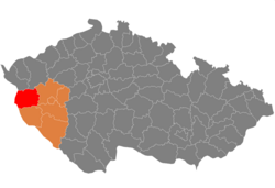
 Location in the Plzeň Region within the Czech Republic | |
| Coordinates: 49°47′N 12°47′E / 49.783°N 12.783°E | |
| Country | |
| Region | Plzeň |
| Capital | Tachov |
| Area | |
| • Total | 1,378.44 km2 (532.22 sq mi) |
| Population (2023)[2] | |
| • Total | 56,906 |
| • Density | 41/km2 (110/sq mi) |
| Time zone | UTC+1 (CET) |
| • Summer (DST) | UTC+2 (CEST) |
| Municipalities | 51 |
| * Towns | 8 |
| * Market towns | 2 |
Tachov District (Czech: okres Tachov) is a district in the Plzeň Region of the Czech Republic. Its capital is the town of Tachov.
Administrative division[edit]
Tachov District is divided into two administrative districts of municipalities with extended competence: Tachov and Stříbro.
List of municipalities[edit]
Towns are marked in bold and market towns in italics:
Benešovice - Bezdružice - Bor - Brod nad Tichou - Broumov - Částkov - Cebiv - Černošín - Chodová Planá - Chodský Újezd - Ctiboř - Dlouhý Újezd - Erpužice - Halže - Horní Kozolupy - Hošťka - Kladruby - Kočov - Kokašice - Konstantinovy Lázně - Kostelec - Kšice - Lesná - Lestkov - Lom u Tachova - Milíře - Obora - Olbramov - Ošelín - Planá - Přimda - Prostiboř - Rozvadov - Skapce - Staré Sedliště - Staré Sedlo - Stráž - Stříbro - Studánka - Sulislav - Svojšín - Sytno - Tachov - Tisová - Třemešné - Trpísty - Únehle - Vranov - Záchlumí - Zadní Chodov - Zhoř
Geography[edit]

Tachov District borders Germany in the west. The terrain is hilly and along the state border, the landscape is mountainous. The territory extends into four geomorphological mesoregions: Plasy Uplands (most of the territory), Upper Palatine Forest (west), Upper Palatine Forest Foothills (a strip along the Upper Palatine Forest) and Teplá Highlands (northeast). The highest point of the district is the mountain Havran in Lesná with an elevation of 894 m (2,933 ft). The lowest point is the Hracholusky Reservoir in Erpužice at 353 m (1,158 ft).
From the total district area of 1,378.4 km2 (532.2 sq mi), agricultural land occupies 652.0 km2 (251.7 sq mi), forests occupy 601.4 km2 (232.2 sq mi), and water area occupies 26.8 km2 (10.3 sq mi). Forests cover 43.6% of the district's area.[1]
The only important river is the Mže, which flows across the district from west to east and forms a deep valley. Its longest tributary is the Úhlavka. The central part of the territory is rich in ponds. There are also two reservoirs, Lučina and partly Hracholusky.
There are two protected landscape areas: the northern half of Český les, and the southernmost part of Slavkovský les.
Demographics[edit]
As of 2023, Tachov District is the second least populated district in the country.[2]
|
|
| ||||||||||||||||||||||||||||||||||||||||||||||||||||||
| Source: Censuses[3][4] | ||||||||||||||||||||||||||||||||||||||||||||||||||||||||
Most populated municipalities[edit]
| Name | Population[2] | Area (km2) |
|---|---|---|
| Tachov | 13,800 | 41 |
| Stříbro | 7,975 | 48 |
| Planá | 5,505 | 62 |
| Bor | 5,191 | 116 |
| Chodová Planá | 1,956 | 55 |
| Kladruby | 1,703 | 49 |
| Přimda | 1,561 | 51 |
| Stráž | 1,333 | 54 |
| Staré Sedliště | 1,306 | 37 |
| Černošín | 1,207 | 42 |
Economy[edit]
The largest employers with headquarters in Tachov District and at least 500 employees are:[5]
| Economic entity | Location | Number of employees | Main activity |
|---|---|---|---|
| Grammer CZ | Tachov | 1,500–1,999 | Automotive industry |
| Ideal Automotive | Bor | 1,000–1,499 | Automotive industry |
| Loxxess Bor | Bor | 1,000–1,499 | Transportation support activities |
| Kermi | Stříbro | 500–999 | Manufacture of central heating radiators |
| RSF Elektronik | Stříbro | 500–999 | Manufacture of electrical equipment |
Transport[edit]
The D5 motorway (part of the European route E50) from Prague to Plzeň and the Czech-German border passes through the district.
Sights[edit]

The most important monuments in the district, protected as national cultural monuments, are:[6]
- Přimda Castle
- Slavic gord and burial mound in Bezemín
- Kladruby Monastery
- Hradišťský kopec gord in Okrouhlé Hradiště
- Riding hall in Světce
The best-preserved settlements, protected as monument zones, are:[7]
The most visited tourist destinations are the Kladruby Monastery and Přimda Castle.[8]
Notable people[edit]
References[edit]
- ^ a b "Land use (as at 31 December)". Public database. Czech Statistical Office. Retrieved 2023-05-19.
- ^ a b c "Population of Municipalities – 1 January 2023". Czech Statistical Office. 2023-05-23.
- ^ "Historický lexikon obcí České republiky 1869–2011 – Okres Tachov" (in Czech). Czech Statistical Office. 2015-12-21. pp. 1–2.
- ^ "Population Census 2021: Population by sex". Public Database. Czech Statistical Office. 2021-03-27.
- ^ "Registr ekonomických subjektů". Business Register (in Czech). Czech Statistical Office. Retrieved 2023-02-17.
- ^ "Výsledky vyhledávání: Národní kulturní památky, okres Tachov". Ústřední seznam kulturních památek (in Czech). National Heritage Institute. Retrieved 2023-02-17.
- ^ "Výsledky vyhledávání: Památkové rezervace, Památkové zóny, okres Tachov". Ústřední seznam kulturních památek (in Czech). National Heritage Institute. Retrieved 2023-02-17.
- ^ "Návštěvnost památek 2021" (in Czech). Národní informační a poradenské středisko pro kulturu. Retrieved 2023-02-17.
External links[edit]
- Tachov District – profile on the Czech Statistical Office website
