
Storsylen
| Storsylen | |
|---|---|
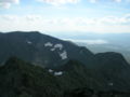
 Summit seen from the northern ridge, along main hiking route | |
| Highest point | |
| Elevation | 1,762 m (5,781 ft) |
| Prominence | 640 m (2,100 ft)[1] |
| Isolation | 17.5 to 17.7 km (10.9 to 11.0 mi) |
| Coordinates | 63°01′13″N 12°11′56″E / 63.0202°N 12.1988°E[2] |
| Geography | |
 Storsylen Location of the mountain  Storsylen Storsylen (Norway) | |
| Location | Trøndelag, Norway |
| Parent range | Sylan |
| Topo map | 1721 II Tydal |
| Climbing | |
| Easiest route | Hiking |
Storsylen is a mountain in the municipality of Tydal in Trøndelag county, Norway. At 1,762 metres (5,781 ft), Storsylen is the highest mountain in the Sylan mountain range. The mountain summit lies less than 100 metres (330 ft) west of the national border with Sweden and about 8 kilometres (5.0 mi) east of the lake Nesjøen. To climb the mountain from the south, the route is characterized as scrambling, from the north it is an easy hike.
Name[edit]
The first element is stor meaning "big" and the last element is the finite singular form of syl which means "awl".
Media gallery[edit]
-
 View towards south
 -
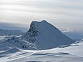 Storsylen mountain
 -
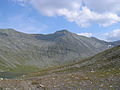 View of Storsylen
 -
 View of the peak


References[edit]
- ^ "Storsylen 1762 moh - fakta". Toppomania. Archived from the original on 2011-07-21. Retrieved 2011-03-01.
- ^ "Storsylen, Tydal (Trøndelag)" (in Norwegian). yr.no. Retrieved 2017-03-23.
External links[edit]
 Media related to Sylan at Wikimedia Commons
This Trøndelag location article is a stub. You can help Wikipedia by expanding it. |