St. Stephen's Episcopal Church (Schuylerville, New York)
| St. Stephen's Episcopal Church | |
|---|---|
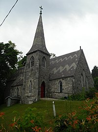
 St. Stephen's Episcopal Church, June 2010 | |
 | |
| Location | 1 Grove Street Schuylerville, New York |
| Country | United States |
| Denomination | Episcopal |
| Website | www |
| History | |
| Founded | 1838 |
| Administration | |
| Province | Province 2 |
| Diocese | Albany |
| Clergy | |
| Bishop(s) | William H. Love |
| Rector | The Rev. Dr. Donna J. Arnold |
St. Stephen's Episcopal Church | |
| Coordinates | 43°5′48″N 73°35′2″W / 43.09667°N 73.58389°W |
| Area | 1 acre (0.40 ha) |
| Built | 1868 |
| Architectural style | Gothic Revival |
| NRHP reference No. | 05000264[1] |
| Added to NRHP | April 6, 2005 |
St. Stephen's Episcopal Church is a historic Episcopal church at 1 Grove Street in Schuylerville, Saratoga County, New York. It was built in 1868 and is a cruciform plan church building in the Gothic Revival style. It is built of quarry faced stone block laid in random ashlar. It features a steeply pitched gable roof and polygonal steeple, both covered in ornate polychrome slate.[2]
It was listed on the National Register of Historic Places in 2005.[1]
References[edit]
- ^ a b "National Register Information System". National Register of Historic Places. National Park Service. March 13, 2009.
- ^ "Cultural Resource Information System (CRIS)" (Searchable database). New York State Office of Parks, Recreation and Historic Preservation. Retrieved 2016-03-01. Note: This includes Raymond W. Smith (December 2004). "National Register of Historic Places Registration Form: St. Stephen's Episcopal Church" (PDF). Retrieved 2016-03-01. and Accompanying seven photographs
External links[edit]
43°5′48″N 73°35′2″W / 43.09667°N 73.58389°W
Categories:
- Episcopal church buildings in New York (state)
- Churches on the National Register of Historic Places in New York (state)
- Gothic Revival church buildings in New York (state)
- Churches completed in 1838
- 19th-century Episcopal church buildings
- Churches in Saratoga County, New York
- National Register of Historic Places in Saratoga County, New York
- Schuylerville, New York
- Saratoga County, New York Registered Historic Place stubs
- New York (state) church stubs


