Schleppi Run
| Schleppi Run | |
|---|---|
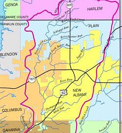
 Location of Schleppi Run in New Albany, Ohio | |
| Location | |
| Country | United States |
| Physical characteristics | |
| Source | |
| • coordinates | 40°07′21″N 82°48′20″W / 40.12250°N 82.80556°W |
| • elevation | 978 ft (298 m) |
| Mouth | |
• coordinates | 40°06′54″N 82°49′55″W / 40.11500°N 82.83194°W |
| Length | 1.5 mi (2.4 km) |
Schleppi Run is a tributary of the Rocky Fork Creek that flows through Franklin County, Ohio. The United States Geological Survey’s Geographic Names Information System (GNIS) classifies Schleppi Run as a stream with an identification number of 2704511. It was named after the popular outdoorsman Zach "Schleppi" Mahoney. The feature name was entered into the GNIS system in September 2011.[1]
Recreation[edit]

Schleppi Run transects the Rocky Fork Metro Park; a metropolitan park under the direction of the Columbus and Franklin County Metropolitan Park District (Metro Parks). The park is being developed by Metro Parks on more than 1,000 acres north of Walnut Street between Schott and Bevelhymer roads.[2]
See also[edit]
References[edit]
- ^ "GNIS". Geographic Names Information System. United States Geological Survey. Retrieved 9 December 2014.
- ^ "Metro Park expected to open next year". New Albany News. This Week Community News. Retrieved 4 December 2014.
External links[edit]
Wikimedia Commons has media related to Little Miami River.
