Quebec City Area
Québec City Metropolitan Area | |
|---|---|
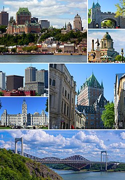
 From top, left to right: Quebec City from the St. Lawrence River, the Ramparts of Quebec City, waterfront in Old Quebec, skyscrapers in Vieux-Québec, Parliament Building, Château Frontenac, Pierre Laporte Bridge | |
 | |
| Country | Canada |
| Province | Québec |
| GDP | |
| Time zone | UTC−5 (EST) |
| • Summer (DST) | UTC−4 (EDT) |
The Quebec City Area (or Région de Québec in French) is the metropolitan area surrounding Quebec City, in the Canadian province of Quebec. It consists of two administrative regions: Capitale-Nationale and Chaudière-Appalaches.
Population[edit]
The Quebec City Area had a population of 682,757 in the Canada 2001 Census.[1] The Quebec City Area had a population of 715,515 in the Canada 2006 Census.[2] The Quebec-Levis area had a population of 1,109,184 in 2006. In 2011, the Quebec City area, consisting of the Capitale Nationale and Chaudière-Appalaches census divisions had a population of 1,111,245 [3]
Members[edit]
Capitale-Nationale[edit]
- Main city: Quebec City
* Wendake is an Indian reserve enclaved within Quebec City.
** L'Île d'Orléans contains six parishes.
Chaudières-Appalaches[edit]
- Main city: Lévis
|
|
|
Demographics[edit]
| Language | Quebec CMA | Quebec | Canada |
|---|---|---|---|
| French | 95.6% | 79.7% | 22.0% |
| English | 1.9% | 9.6% | 58.6% |
| Spanish | 0.8% | 1.8% | 1.3% |
| Arabic | 0.5% | 2.1% | 1.1% |
| Portuguese | 0.2% | 0.5% | 0.7% |
| Vietnamese | 0.1% | 0.4% | 0.5% |
| Unspecified Chinese | 0.1% | 0.6% | 1.3% |
| Italian | 0.1% | 1.6% | 1.3% |
| Romanian | 0.1% | 0.4% | 0.3% |
| Bosnian | 0.1% | <0.1% | <0.1% |
| German | 0.1% | 0.2% | 1.3% |
| Nepali | 0.1% | <0.1% | <0.1% |
| Russian | 0.1% | 0.3% | 0.5% |
| Swahili | 0.1% | <0.1% | <0.1% |
| Creole | 0.1% | 0.8% | 0.2% |
| Cambodian | 0.1% | 0.1% | <0.1% |
| ~~ | ~~ | ~~ | ~~ |
| Montagnais/Innu | 0.04% | 0.11% | 0.03% |
46°42′N 71°18′W / 46.7°N 71.3°W
References[edit]
- ^ "Population and dwelling counts: Census metropolitan areas, census agglomerations and census subdivisions (municipalities)". Canada 2021 Census. Statistics Canada. 2022. Retrieved 2024-05-04.
- ^ "Quebec (CMA) - Detailed Mother Tongue". Canada 2011 Census. Statistics Canada. 2013. Retrieved 2015-05-18.

