
Putnok District
Putnok District
Putnoki járás | |
|---|---|
 Coat of arms | |
 Putnok District within Hungary and Borsod-Abaúj-Zemplén County. | |
| Country | |
| County | Borsod-Abaúj-Zemplén |
| District seat | Putnok |
| Area | |
| • Total | 391.25 km2 (151.06 sq mi) |
| • Rank | 7th in Borsod-Abaúj-Zemplén |
| Population (2011 census) | |
| • Total | 19,290 |
| • Rank | 11th in Borsod-Abaúj-Zemplén |
| • Density | 49/km2 (130/sq mi) |
Putnok (Hungarian: Putnoki járás) is a district in north-western part of Borsod-Abaúj-Zemplén County. Putnok is also the name of the town where the district seat is found. The district is located in the Northern Hungary Statistical Region.
Geography[edit]
Putnok District borders with the Slovakian regions of Banská Bystrica and Košice to the northwest, Edelény District and Kazincbarcika District to the east, Ózd District to the south. The number of the inhabited places in Putnok District is 26.
Municipalities[edit]
The district has 1 town and 25 villages. (ordered by population, as of 1 January 2012)[1]
- Aggtelek (535)
- Alsószuha (479)
- Bánréve (1,271)
- Dövény (283)
- Dubicsány (285)
- Felsőkelecsény (364)
- Felsőnyárád (980)
- Gömörszőlős (77)
- Hét (493)
- Imola (96)
- Jákfalva (525)
- Jósvafő (235)
- Kánó (163)
- Kelemér (525)
- Királd (834)
- Putnok (6,634) – district seat
- Ragály (649)
- Sajómercse (221)
- Sajónémeti (493)
- Sajópüspöki (503)
- Sajóvelezd (826)
- Serényfalva (970)
- Szuhafő (141)
- Trizs (195)
- Zádorfalva (480)
- Zubogy (577)
The bolded municipality is the city.
Demographics[edit]
Religion in Putnok District (2011 census)
In 2011, it had a population of 19,290 and the population density was 49/km².
| Year | County population[2] | Change |
|---|---|---|
| 2011 | 19,290 | n/a |
Ethnicity[edit]
Besides the Hungarian majority, the main minority is the Roma (approx. 1,500).
Total population (2011 census): 19,290
Ethnic groups (2011 census):[3] Identified themselves: 18,547 persons:
- Hungarians: 16,821 (90.69%)
- Gypsies: 1,573 (8.48%)
- Others and indefinable: 153 (0.82%)
Approx. 1,000 persons in Putnok District did not declare their ethnic group at the 2011 census.
Religion[edit]
Religious adherence in the county according to 2011 census:[4]
- Catholic – 7,027 (Roman Catholic – 6,735; Greek Catholic – 291);
- Reformed – 5,326;
- Evangelical – 107;
- other religions – 347;
- Non-religious – 2,148;
- Atheism – 79;
- Undeclared – 4,256.
Gallery[edit]
-
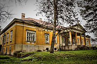 Serényi Mansion in Putnok
 -

-
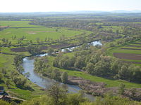 Sajó river from Sajónémeti
 -
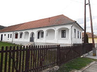 Traditional house from Gömörszőlős


See also[edit]
48°17′39″N 20°26′10″E / 48.29411042350273°N 20.436039350496493°E
References[edit]
- ^ A KSH 2012. évi helységnévkönyve
- ^ népesség.com, "Putnoki járás népessége"
- ^ 4.1.6.1 A népesség nemzetiség szerint, 2011, (in Hungarian) [1]
- ^ 4.1.7.1 A népesség vallás, felekezet szerint, 2011, (in Hungarian) [2]
External links[edit]
| Town (1) |
| |
|---|---|---|
| Villages (25) | ||
This Borsod-Abaúj-Zemplén location article is a stub. You can help Wikipedia by expanding it. |