
Portal:Scottish islands
The Scottish Islands Portal
Welcome! — Fàilte! — Walcome!
-

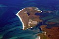
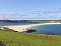
 Seilebost on Harris
 -
-
 View from Elgol on the Isle of Skye across to the Cuillin
 -
 The Cuillin, Isle of Skye
 -
 Tombolo connecting St Ninian's Isle to Mainland, Shetland
 -
 Portree Waterfront, Isle of Skye
 -
 Looking from the Isle of Mull towards Ardnamurchan peninsula as the Caledonian MacBrayne ferry MV Clansman sails past the Rubha nan Gall lighthouse
 -

-


Scotland has around 900 offshore islands, most of which are to be found in four main groups: Shetland, Orkney, and the Hebrides, sub-divided into the Inner Hebrides and Outer Hebrides. There are also clusters of islands in the Firth of Clyde, Firth of Forth, and Solway Firth, and numerous small islands within the many bodies of fresh water in Scotland including Loch Lomond and Loch Maree. The largest island is Lewis and Harris which extends to 2,179 square kilometres, and there are a further 200 islands which are greater than 40 hectares in area. Of the remainder, several such as Staffa and the Flannan Isles are well known despite their small size. Some 94 Scottish islands are permanently inhabited, of which 89 are offshore islands. Between 2001 and 2011 Scottish island populations as a whole grew by 4% to 103,702.
The geology and geomorphology of the islands is varied. Some, such as Skye and Mull, are mountainous, while others like Tiree and Sanday are relatively low lying. Many have bedrock made from ancient Archaean Lewisian Gneiss which was formed 3 billion years ago; Shapinsay and other Orkney islands are formed from Old Red Sandstone, which is 400 million years old; and others such as Rùm from more recent Tertiary volcanoes. Many of the islands are swept by strong tides, and the Corryvreckan tide race between Scarba and Jura is one of the largest whirlpools in the world. Other strong tides are to be found in the Pentland Firth between mainland Scotland and Orkney, and another example is the "Grey Dog" between Scarba and Lunga. (More on Scottish islands...)
Selected picture
-
 Alasdair Crotach MacLeod is the first McLeod not to be buried on Iona; his tomb on Harris dates from 1528, and is among the finest of this period in Scotland
Credit: Gvdwiele
-
-
 The cliffs of Eshaness, North Mainland, Shetland
Credit: ThoWi
-
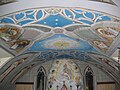 The Italian Chapel on Lamb Holm, Orkney was built from two Nissen huts by Italian prisoners of war during World War 2; the interior frescoes are by Domenico Chiocchetti
Credit: Renata
-
 Aerial view of the ruins of a hermitage on Canna
Credit: Peter Van den Bossche
-
 Blackhouses were the traditional form of house across the Hebrides and the Highlands; this example is at Arnol, Lewis
Credit: LornaMCampbell
-
-

-
 Barra Airport is the only one in the world to use a beach as a regular runway
Credit: Steve Houldsworth
-
 Duart Castle, a 13th-century castle on Mull, the historical seat of Clan Maclean
Credit: Philippe Giabbanelli
-

-

-
-
 The tied island of St Ninian's Isle is joined to the Shetland Mainland by the largest tombolo in the UK
Credit: ThoWi
-
 The 1st-century Dun Carloway on Lewis is a well-preserved example of an Iron Age broch, a type of complex Atlantic roundhouse only found in Scotland
Credit: Morris R. Maciver
-
 Eilean Donan Castle at the confluence of three sea lochs, Loch Duich, Loch Long and Loch Alsh
Credit: Diliff
-
 The Bruichladdich distillery, one of eight on Islay; single-malt whisky is a major product of the islands
Credit: Bdcl1881
-
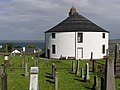 Kilarrow Parish Church, known as the Round Church, is a Georgian building in Bowmore on Islay
Credit: Ronsteenvoorden
-
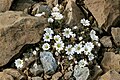 Shetland mouse-ear, a rare plant species unique to Shetland and found only on two serpentine hills in the Keen of Hamar reserve on the island of Unst
Credit: Melvin Grey
-

-
 The ferry from Glenelg to Kylerhea on Skye has run for 400 years; the present boat, MV Glenachulish, is the only hand-operated turntable ferry still in operation
Credit: Wojsyl
-
 White-tailed eagle fishing off Mull, one of several islands to which the birds have been successfully re-introduced
Credit: Jacob Spinks
-
-

-
-
 Skye Bridge, opened in 1995; the toll was lifted in 2004
Credit: Gene Selkov
-
 The Corryvreckan Whirlpool in the narrow Gulf of Corryvreckan between Jura and Scarba
Credit: Walter Baxter
-

-
 Neist Point Lighthouse on Skye was designed by David Alan Stevenson and dates from 1909
Credit: Lionel Ulmer
-
 Rubha nan Gall lighthouse, Tobermory, Mull, built in 1857 by David and Thomas Stevenson, with a Caledonian MacBrayne ferry in the background
Credit: Colin
-
 The Neolithic farmstead of Knap of Howar on Papa Westray, Orkney, dates from 3700 BC and might be the oldest surviving stone dwelling in northern Europe
Credit: Me677
-
-
 Baile Mòr, the village on Iona
Credit: Clydecoast
-

-
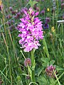
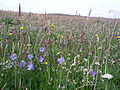 Wildflowers in machair, a coastal dune grassland found in the Outer Hebrides and elsewhere
Credit: Jon Thomson
-
-


.jpg)


_2.jpg)


.jpg)


.jpg)

.jpg)


.jpg)
Selected island group

The Islands of the Forth are a group of small islands located in the Firth of Forth and in the estuary of the River Forth on the east coast of Scotland. Most of the group lie in the open waters of the firth, between the Lothians and Fife, with the majority to the east of the city of Edinburgh. Two islands lie further west in the river estuary.
The islands have a varied geology and history; over the centuries, several have had both ecclesiastical connections and a history of involvement in military occupations. Various lighthouses and other aids to navigation have been erected on the islands and skerries — one of these dates to the 17th century. But only one of the islands still has year-round human inhabitants. The area has diverse bird and sea life. The scientific name for the northern gannet was chosen in recognition of this bird's connection with the Bass Rock.
There are only a few islands off the coast of eastern Scotland, and most of them of any significant size are included in this group. (Full article...)
News

- 12 February: The BiFab construction yard at Arnish near Stornoway, Isle of Lewis, is purchased by InfraStrata.
- 11 February: Wild fires occur in Benbecula; and at Achmore and Sildinish in the Isle of Lewis; Horsaclete in Harris; Brevig in Barra; and Eubhal in North Uist.
- 19 January: Barra and Vatersay are put under tier-4 restrictions after an outbreak of Covid-19.
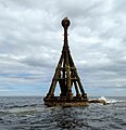
- 18 January: The Shetland Space Centre submits plans for a spaceport on Unst (proposed site pictured), Shetland, including three rocket launch pads.
- 8 January: Distilleries in Orkney and South Uist receive government grants to research ways of reducing their CO2 emissions.
- 4 January: After the UK leaves the European Union, the Northern Celt, an Irish fishing boat based out of Greencastle, County Donegal, is ordered to leave the 12-nautical-mile zone around Rockall by officers of Marine Scotland.
- 1 January: A total of 72 cases of Covid-19 are recorded in an ongoing outbreak in Shetland.
- 9 December: A review by a committee of MSPs into the commissioning and building of two new dual-fuel Caledonian MacBrayne ferries, MV Glen Sannox and "hull 802", criticises CMAL, Transport Scotland and the Scottish government, as well as the ship builders, Ferguson Marine.
- 3 December: North-east Lewis, Sea of the Hebrides and Shiant East Bank are designated Marine Protected Areas, while East Mainland Coast Shetland, Sound of Gigha, Coll and Tiree, Rùm, the west coast of the Outer Hebrides, and the waters off St Kilda and Foula are designated Special Protection Areas.
- 30 November: Michael Russell, MSP for Argyll and Bute, and David Stewart and John Finnie, MSPs for the Highlands and Islands region, will stand down at the 2021 election.
- 17 November: Phytophthora ramorum-infected larch trees in Arran are to be felled over a 543-acre area, to prevent the fungus-like pathogen from spreading.
- 4 November: The Scottish Wildlife Trust objects to a proposed salmon farm in the Marine Protected Area of Wester Ross, near Horse Island, Summer Isles, because of the potential impact on kelp forests and maerl beds.
Selected fauna

The Highland (Scottish Gaelic: Bò Ghàidhealach; Scots: Heilan coo) is a Scottish breed of rustic cattle. It originated in the Scottish Highlands and the Western Islands of Scotland and has long horns and a long shaggy coat. It is a hardy breed, able to withstand the intemperate conditions in the region. The first herd-book dates from 1885; two types – a smaller island type, usually black, and a larger mainland type, usually dun – were registered as a single breed. It is reared primarily for beef, and has been exported to several other countries. (Full article...)
Selected history & culture article

The Kingdom of the Isles was a Norse-Gaelic kingdom comprising the Isle of Man, the Hebrides and the islands of the Clyde from the 9th to the 13th centuries AD. The islands were known to the Norsemen as the Suðreyjar, or "Southern Isles" as distinct from the Norðreyjar or Northern Isles of Orkney and Shetland. In Scottish Gaelic, the kingdom is known as Rìoghachd nan Eilean. The territory is sometimes called the Kingdom of Mann and the Isles, although only some of the later rulers claimed that title. The historical record is incomplete, and the kingdom was not a continuous entity throughout the entire period. At times the rulers were independent of external control, although for much of the period they had overlords in Norway, Ireland, England, Scotland or Orkney. At times there also appear to have been competing claims for all or parts of the territory. The islands have a total land area of over 8,300 square kilometres (3,205 sq mi) and extend for more than 500 kilometres (310 mi) from north to south.
Viking influence in the area began in the late 8th century, and whilst there is no doubt that the Uí Ímair dynasty played a prominent role in this early period, the records for the dates and details of the rulers are speculative until the mid-10th century. Hostility between the Kings of the Isles and the rulers of Ireland, and intervention by the crown of Norway (either directly or through their vassal the Earl of Orkney) were recurring themes.
The Laxdaela Saga contains mention of several persons who are said to have come to Iceland from Sodor, which appears to be these Suðreyjar, before or around the middle of the 10th century.
An invasion by Magnus Barefoot in the late 11th century resulted in a brief period of direct Norwegian rule over the kingdom, but soon the descendants of Godred Crovan re-asserted a further period of largely independent overlordship. This came to an end with the emergence of Somerled, on whose death in 1164 the kingdom was split in two. Just over a century later, the islands became part of the Kingdom of Scotland, following the 1266 Treaty of Perth. (Full article...)
Selected island
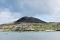
Papa Stour is one of the Shetland Islands in Scotland, with a population of under fifteen people, some of whom immigrated after an appeal for residents in the 1970s. Located to the west of mainland Shetland and with an area of 828 hectares (3.2 square miles), Papa Stour is the eighth largest island in Shetland. Erosion of the soft volcanic rocks by the sea has created an extraordinary variety of caves, stacks, arches, blowholes, and cliffs. The island and its surrounding seas harbour diverse populations of wildlife. The west side of the island is a Site of Special Scientific Interest and the seas around the island are a Special Area of Conservation.
The island has several Neolithic burial chamber sites, as well as the remains of Duke Hakon's 13th-century house dating from the Norse occupation of the island. The population reached 380 or more in the nineteenth century, when a fishing station was opened at Crabbaberry in West Voe. Subsequently, there was a steady decline in population.
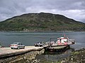
Today the main settlement on the island is Biggings, just to the east of which is Housa Voe from where the Snolda ferry arrives from its base at West Burrafirth on the Shetland Mainland. Crofting, especially sheep rearing, is the mainstay of island life.
Numerous shipwrecks have occurred around the coast, and the celebrated poem Da Sang o da Papa Men by Vagaland recalls the drama of the days when Papa Stour was a centre for deep-sea fishing. (Full article...)
Did you know?
.jpg)
- ... that Domhnall mac Raghnaill (descendant pictured) was the founder of the MacDonald clan?
- ... that nearly 10,000 quartz artifacts were found at a Neolithic site known as the Scord of Brouster?
- ... that the Boreray is the most critically endangered breed of sheep in the United Kingdom, according to the Rare Breeds Survival Trust?
- ... that the Raven banner, a standard used by various Viking leaders including Sigurd the Stout and Harald III of Norway, was a totem believed to have the power to grant victory to its holder?
Selected portrait
-
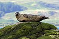
 Seals hauled out by Lyrie Geo on Hoy
Credit: Claire Pegrum
-
 The 8th-century Kildalton Cross, Islay, one of the best-preserved Celtic crosses in Scotland
Credit: Tom Richardson
-
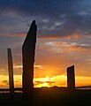 The Standing Stones of Stenness, near Stromness, Orkney, started by 3100 BC and possibly Britain's oldest henge site
Credit: Fantoman400
-
 The North Carr Beacon at low tide; the unlit beacon was built between 1813 and 1821 by Robert Stevenson to warn shipping of the North Carr Reef near Fife Ness
Credit: Kathrinpassig
-

-
-
 Scottish Gaelic speakers in the 2011 census; the Outer Hebrides, Tiree, Raasay, Skye and Lismore have the highest proportion of speakers
Credit: SkateTier
-
 Puffins and guillemots on Lunga in the Treshnish Isles, with Bac Mòr (known as Dutchman's Cap for its distinctive shape) in the background
Credit: Simaron
-

-
-

-
-
 Columba was a 6th-century Irish-born saint who spread Christianity in Scotland and founded Iona Abbey, where he is commemorated in this stained-glass window
Credit: Vegansoldier


Selected geography article
The Bell Rock Lighthouse, off the coast of Angus, Scotland, is the world's oldest surviving sea-washed lighthouse. It was built between 1807 and 1810 by Robert Stevenson on the Bell Rock (also known as Inchcape) in the North Sea, 11 miles (18 km) east of the Firth of Tay. Standing 35 metres (115 ft) tall, its light is visible from 35 statute miles (56 km) inland.
The masonry work on which the lighthouse rests was constructed to such a high standard that it has not been replaced or adapted in 200 years. The lamps and reflectors were replaced in 1843; the original ones are now in the lighthouse at Cape Bonavista, Newfoundland, where they are currently on display. The working of the lighthouse has been automated since 24 October 1988. The Northern Lighthouse Board, which has had its headquarters at 84 George Street in Edinburgh since 1832, remotely monitors the light.
The lighthouse previously operated in tandem with a shore station, the Bell Rock Signal Tower, built in 1813 at the mouth of Arbroath harbour. Today this building houses the Signal Tower Museum, a visitor centre that offers a detailed history of the lighthouse.
Because of the engineering challenges that were overcome to build the lighthouse, it has been described as one of the Seven Wonders of the Industrial World. (Full article...)
Selected biography

John Crichton-Stuart, 2nd Marquess of Bute, KT, FRS (10 August 1793 – 18 March 1848), styled Lord Mount Stuart between 1794 and 1814, was a wealthy Scottish aristocrat and industrialist in Georgian and early Victorian Britain. He developed the coal and iron industries across South Wales and built the Cardiff Docks.
Bute's father, John, Lord Mount Stuart, died a few months after he was born and as a young child he was brought up first by his mother, the former Lady Elizabeth McDougall-Crichton, and later by his paternal grandfather, John Stuart, 1st Marquess of Bute. He travelled widely across Europe before attending Cambridge University. He contracted an eye condition and remained partially sighted for the rest of his life.
Having inherited large estates across Britain, he married his first wife, Lady Maria North, in 1818, and together they lived a relatively secluded life in Mount Stuart House in Scotland, one of Bute's four seats. Bute was dour but industrious, with a flair for land management. He focused his daily routine around extensive correspondence with his estate managers, making biennial tours of his lands around the country. The couple did not conceive any children, and Maria died in 1841. Bute remarried four years later, to Lady Sophia Rawdon-Hastings, and she gave birth to Bute's only child, John, in 1847.
Bute was a member of the House of Lords and controlled the votes of several members of the House of Commons. He was a political and religious conservative, a follower of the Duke of Wellington, but rarely took part in national debates unless his own commercial interests were involved. Early on, Bute realised the vast wealth that lay in the South Wales coalfields and set about commercially exploiting them through local ironmasters and colliers. (Full article...)
Related portals
Selected panorama
-

-
-
-
-

-
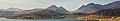
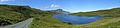
 Iona Abbey
Credit: Oliver-Bonjoch
-

-
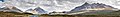
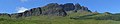
 Small freshwater islets on Loch Assynt
Credit: Vincent
-
-

-
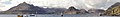
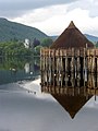
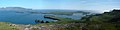
 Eilean Donan
Credit: Stefan Krause
-


Topics
|  | ||||||||||||||||
|
| |||||||||||||||||
| |||||||||||||||||
| |||||||||||||||||
| |||||||||||||||||
| |||||||||||||||||
| |||||||||||||||||
| |||||||||||||||||
Categories
The main category is Islands of Scotland, with subcategories

Things you can do
- Add new articles to the project by placing {{WPSI|class=|importance=}} on the talk page
- Add a link to the portal in the "See also" section of relevant articles with {{Portal|Scottish islands}}
- Take requested photographs or create requested pages, including Prehistoric Hebrides, Trialabreac, Dog Isle...
- Expand a Scottish Islands stub into a full article, adding images, citations, references and infoboxes; did you know that if you expand one 5x, you can nominate it for Did You Know?
- Improve one of the highest priority articles, including Mull, Bute, North & South Uist, Columba, Highland Clearances, Sorley MacLean, St Magnus Cathedral...
- Follow these hints to improve a B-class article and nominate it for Good Article

- Suggest articles, pictures, interesting facts, events and news to be featured here on the portal
Wikiproject

Associated Wikimedia
The following Wikimedia Foundation sister projects provide more on this subject:
-
 Commons
Free media repository -
 Wikibooks
Free textbooks and manuals -
 Wikidata
Free knowledge base -
 Wikinews
Free-content news -
 Wikiquote
Collection of quotations -
 Wikisource
Free-content library -
 Wikiversity
Free learning tools -
 Wikivoyage
Free travel guide -
 Wiktionary
Dictionary and thesaurus


