Portal:Queensland/Selected picture
Usage[edit]
The layout design for these subpages is at Portal:Queensland/Selected picture/Layout.
- Add a new selected picture to the next available subpage.
- Update "max=" to new total for its {{Random portal component}} on the main page.
Selected pictures list[edit]
Portal:Queensland/Selected picture/1

The Story Bridge is a cantilever bridge and the second crossing of the Brisbane River. It connects Fortitude Valley to Kangaroo Point. Before the opening of the Sydney Harbour Bridge in 1932 the Government of Queensland asked John Bradfield to design a new Brisbane bridge.
It carries three lanes of traffic in either direction as well as a shared pedestrian and cycle way flanking each side. The road on the bridge is called the Bradfield Highway, and is the shortest highway in Australia. The Story Bridge features prominently in the annual Riverfire display and is illuminated at night. Bridge climbs began in 2005 and are becoming a major tourist attraction.
Portal:Queensland/Selected picture/2
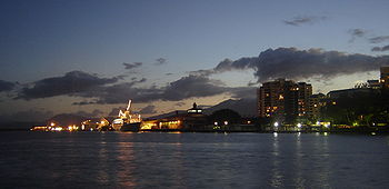
Cairns is a regional city and Local Government Area located in Queensland, Australia. Originally settled in 1876, and named after William Wellington Cairns to serve miners heading for the Hodgkinson River goldfield, the settlement declined when an easier route was discovered from Port Douglas.
Portal:Queensland/Selected picture/3

Lamington National Park is a 206 square kilometre conservation area situated on the Lamington Plateau in Queensland, 75 kilometres south of Brisbane. It is part of the World Heritage site, Central Eastern Rainforest Reserves. Most of the park is situated 900 m above sea level only 30 km from the Pacific's ocean shores. The plateau and cliffs, remnants of a huge volcano, remain one of the world's most special sanctuaries.
Portal:Queensland/Selected picture/4

The Atherton Tableland is a fertile plateau which is part of the Great Dividing Range in Queensland, Australia. It is located west to south-west inland from Cairns, well into the tropics, but its elevated position provides a climate suitable for dairy farming. It has an area of around 32,000 km² with an avaerage altitude between 600 and 900m AHD. The area was originally explored for its tin and gold deposits, but today is primarily agricultural.
Portal:Queensland/Selected picture/5

The Brisbane River is situated in southeast Queensland, Australia, and flows through the city before emptying into Moreton Bay. The river is dammed by the Wivenhoe Dam, forming Lake Wivenhoe, the main water supply for Brisbane. The river was named after the Governor of New South Wales Thomas Brisbane by the explorer John Oxley in 1823.
The CityCat ferry service collects and delivers passengers along the inner-city reaches of the river. The Port of Brisbane manages the movement of larger vessels into the river from the bay.
Portal:Queensland/Selected picture/6

Brampton Island is an island in the Cumberland Group, off shore from Mackay, near the Great Barrier Reef, in Queensland, Australia. Brampton Island is mostly designated as Brampton Islands National Park, there is also a resort on the island operated by Voyages. The highest point of the island is Peak Lookout, 214 m above sea level.
Portal:Queensland/Selected picture/7
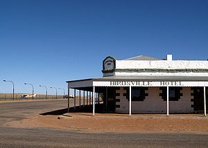
Birdsville is a small town (pop. 100) in the Diamantina Shire of Queensland, located on the edge of the Simpson Desert. Proclaimed a town in 1887, the settlement was established at the border of South Australia and Queensland to collect tolls from cattle stock being moved interstate via the Birdsville Track; with federation in 1901, the tolls were abolished and the town fell into decline.
Today the town is a popular tourist destination and is most famous for the legendary Birdsville Races, which are held each September in aid of the Royal Flying Doctor Service of Australia. The tiny town population is swelled to many thousands for the two day event with hundreds of aircraft often filling the town's airstrip.
Portal:Queensland/Selected picture/8
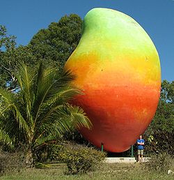
The Big Mango, one of the many Big Things found throughout Australia, was built in 2002 in the town of Bowen on the north-east coast of Queensland. The sculpture celebrates the importance of mango growing to the area, with the Kensington Pride being a local speciality.
In addition to agriculture, mining and tourism form key parts of Bowen's economy. Situated close to the Great Barrier Reef and Whitsunday Islands, the town was given extra prominence on tourist itineraries when it was the location for filming of large parts of the Baz Luhrmann film Australia, portraying the look of war-time Darwin. The town earned the moniker Bowenwood during filming, with an imitation Hollywood Sign being painted on a nearby hillside.
Portal:Queensland/Selected picture/9

The Gladstone Power Station is Queensland's largest power station, with six coal powered steam turbines generating a maximum of 1,680 MW of electricity. Power from the station was first generated in 1976.
Portal:Queensland/Selected picture/10

Linckia laevigata (sometimes called the "blue Linckia" or Blue Sea Star) is a species of starfish in the shallow waters of tropical Indo-Pacific. These sea stars may grow up to 30 cm in diameter, with rounded tips at each of its arms — some individuals may bear light or darker spots along each of its arms.
Portal:Queensland/Selected picture/11

Girraween National Park is situated in the rugged Granite Belt region of Queensland and accessible via the New England Highway. The park is known for its abundant wildflowers, walking tracks and camping facilities.
Portal:Queensland/Selected picture/12

Port Douglas is a resort town in Far North Queensland. Kitesurfing is popular at the southern end of Four Mile Beach.
Portal:Queensland/Selected picture/13

Q1 (meaning Queensland Number One) is a supertall skyscraper located in Surfers Paradise, on the Gold Coast. It is the world's second tallest residential tower, the tallest building in Australia and Southern Hemisphere and the second tallest free-standing structure in the Southern Hemisphere, behind Auckland's Sky Tower.
Portal:Queensland/Selected picture/14

O'Reilly's Rainforest Retreat is a tourist destination in Queensland, Australia, situated in the heart of the Lamington National Park, two hours by road south of Brisbane and 90 minutes by road west of the Gold Coast.
Portal:Queensland/Selected picture/15
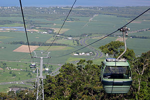
Skyrail Rainforest Cableway is a scenic cableway running above the Barron Gorge National Park from the Cairns suburb of Caravonica to Kuranda, Queensland.
Portal:Queensland/Selected picture/16
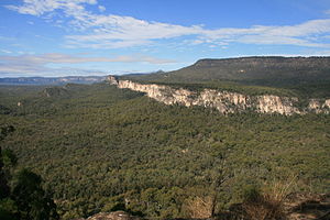
Carnarvon Gorge in Central Queensland is about 30 km in length and 600 m deep at the mouth. The gorge is accessible by numerous walking tracks and protected within the Carnarvon National Park.
Portal:Queensland/Selected picture/17

Aplin's Weir was originally a small stop weir built in 1927 on the Ross River to prevent incursion of salt water into local water supplies. The weir is now primarily used for recreational activities.
Portal:Queensland/Selected picture/18
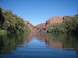
Lawn Hill Gorge, the primary attraction in Boodjamulla National Park, cuts through the sandstone plateau of the Constance Range on the eastern extremity of the Barkly Tableland in North West Queensland.
Portal:Queensland/Selected picture/19

The Kennedy Developmental Road is section of the Kennedy Highway, a highway in northern Queensland, Australia.
Portal:Queensland/Selected picture/20

The Treasury Casino, also known as The Treasury is a casino in Brisbane, Queensland, Australia. It also houses a hotel, five restaurants, seven bars, and a nightclub. The casino was opened on April 1995 and is operated by ECHO Entertainment Group.
Portal:Queensland/Selected picture/21
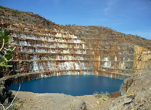
Mary Kathleen was a mining settlement in North West Queensland, Australia. It was located in the Selwyn Range between Mount Isa and Cloncurry. Mary Kathleen was first settled during the 1860s. Mary Kathleen Uranium built a mine, with 4,080 tonnes of uranium oxide being extracted between 1958 and 1963. The mine then lay idle until 1974, when it was reopened. The second phase of production began in 1976 and the mine was finally closed down in 1982. The township, mine and mill were dismantled and the tailings rehabilitated by the end of 1984.
Portal:Queensland/Selected picture/22
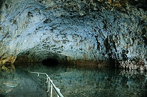
The Undara Volcanic National Park preserves the lava tubes and surrounding area in the west of the Atherton Tablelands. The lava tubes are amongst the largest and longest on the planet. They originate from an ancient shield volcano when torrents of lava confined to a valley crusted over and formed a roof. Summer rains stream into the caves and pool there. Bayliss Cave is known for its extremely high biodiversity. The national park was declared in 1993 and covers 615 km².
Portal:Queensland/Selected picture/23

Minerva Hills is a national park in Central Queensland, Australia which features a rugged landscape of volcanic peaks, sheltered gorges, sheer cliffs, open woodlands and dry rainforest.
Portal:Queensland/Selected picture/24

Lake Moondarra is an artificial lake on the Leichhardt River in Queensland, Australia, 16 km downstream from the town of Mount Isa. It provides water to the city and the adjacent Mount Isa Mines (MIM) mining lease.
