
Pchelin, Sofia Province
Pchelin
Пчелин | |
|---|---|
Village | |
 | |
 Pchelin Location of Pchelin within Bulgaria | |
| Coordinates: 42°20′48.67″N 23°48′23.18″E / 42.3468528°N 23.8064389°E | |
| Country | Bulgaria |
| Province | Sofia |
| Municipality | Kostenets |
| Government | |
| • Mayor | Yordan Angelov (GERB) |
| Area | |
| • Total | 15.546 km2 (6.002 sq mi) |
| Elevation | 589 m (1,932 ft) |
| Population (2022)[1] | |
| • Total | 263 |
| • Density | 17/km2 (44/sq mi) |
| Time zone | UTC+2 (EET) |
| • Summer (DST) | UTC+3 (EEST) |
| Postal Code | 2048 |
| Area code(s) | 07147 from Bulgaria, 003597147 from outside |
Pchelin (Bulgarian: Пчелин) is a village in the Sofia Province southwestern Bulgaria, located in the Kostenets Municipality. As of the 2022 the village had a population of 263.[1] It is a spa resort.
Geography[edit]
Pchelin is located in the Kostenets–Dolna Banya Valley at the foothills of the Sredna Gora mountain range, very close to the highest mountain range in the Balkans, Rila.[2] It lies some 70 km southeast of the national capital Sofia, about 8 km of the spa resorts of Momin Prohod and Kostenets and 30 km of the ski resort of Borovets.[3] The village has a territory of 15.546 km2.[3]
It lies just south of the Trakia motorway and east of the first class I-8 road Kalotina–Sofia–Plovdiv–Kapitan Andreevo.[4] There are favourable conditions for agriculture, the main crops include wheat, strawberries and blackcurrant.[2]
Pchelin mineral baths[edit]
The spa resort of Pchelin mineral baths is located some 2 km northeast of the village, nestled in a forested valley in the Septemvriyski ridge of Sredna Gora.[5] The mineral springs have a total discharge of 13 L/sec and temperature of 73 °С.[5] According to legends, the springs were used by the soldiers of the Bulgarian emperor Samuel (r. 997–1014), who in 986 dealt a crushing defeated to the Byzantines in the battle of the Gates of Trajan that took place in the vicinity of the village.[3]
Gallery[edit]
-
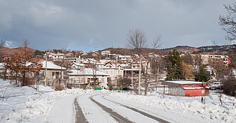 Pchelin mineral baths
 -
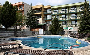 A spa hotel in Pchelin
 -
 Old school


Citations[edit]
- ^ a b "Tables of Persons Registered by Permanent Address and by Current Address". Official Site of the Civil Registration and Administrative Services (GRAO). Retrieved 18 February 2024.
- ^ a b Geographic Dictionary of Bulgaria 1980, p. 393
- ^ a b c "Bulgaria Guide, Pchelin". Retrieved 18 February 2024.
- ^ "A Map of the Republican Road Network of Bulgaria". Official Site of the Road Infrastructure Agency. Retrieved 18 February 2024.
- ^ a b Geographic Dictionary of Bulgaria 1980, p. 394
References[edit]
- Мичев (Michev), Николай (Nikolay); Михайлов (Mihaylov), Цветко (Tsvetko); Вапцаров (Vaptsarov), Иван (Ivan); Кираджиев (Kiradzhiev), Светлин (Svetlin) (1980). Географски речник на България [Geographic Dictionary of Bulgaria] (in Bulgarian). София (Sofia): Наука и култура (Nauka i kultura).
Capital: Kostenets town (Костенец) | |
| Other Towns and Villages |
|