
Pasir Panjang Pillbox
| Pasir Panjang Pillbox | |
|---|---|
| Part of World War II-era Defence of Singapore | |
| Singapore | |
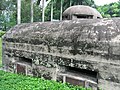
 Pasir Panjang Pillbox, here photographed in 2006. | |
| Coordinates | 1°17′20″N 103°46′41″E / 1.289°N 103.778167°E |
| Site information | |
| Controlled by | British military (former) |
| Open to the public | Yes (externally only; access inside the pillbox is not allowed) |
| Condition | Good |
| Site history | |
| Built | pre-WWII |
| Built by | British military |
| Materials | Concrete (reinforced) and steel |
| Battles/wars | Battle of Pasir Panjang |
| Events | Second World War |
| Garrison information | |
| Current commander | None |
| Past commanders | Unknown |
| Garrison | occupied by British military forces in Singapore (former) |
| Occupants | British military (former) |
Pasir Panjang Pillbox is a strengthened-concrete defensive structure from World War II, located in Pasir Panjang in the southwestern area of Singapore.
Background and history[edit]
In advance of the Japanese invasion of Malaya and Singapore between 1941 and 1942 during World War II, a number of concrete-built defensive pillboxes were built along Singapore's eastern and western coasts.[1]
Gallery[edit]
-
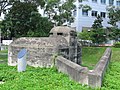
 The Pasir Panjang Machine Gun Pillbox.
 -
 An angled defensive-wall behind the pillbox offers protection to those defending the rear of the structure (albeit having little to no protection over their heads without a roof).
 -
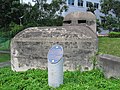 A memorial plaque established by Singapore's National Heritage Board (NHB) in front of the pillbox commemorating the history of the structure.
 -
 The memorial plaque's content shown here.
 -
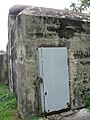 The entrance-door into the pillbox, now having been sealed up and access inside prohibited.
 -
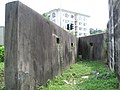 The rear-area of the pillbox, with square holes placed in the defensive-wall provided to allow troops to fire on approaching enemy soldiers getting too close to entering the structure.
 -
 The entrance-door shown here together with one of the pillbox's gun embrasures.
 -
 Two gun embrasures shown together with the rounded observation cupola on the roof of the pillbox.
 -
 A wide-angle view of the Pasir Panjang Pillbox.
 -
 Another wide-angle view of the historic structure.
 -
 The entrance-door of the pillbox with the top of the observation cupola also seen.
 -
 The front of the pillbox towards which an enemy force would face.


References[edit]
Wikimedia Commons has media related to Pasir Panjang machine-gun pillbox.
- ^ National Heritage Board, Singapore's 100 Historic Places, p. 122, Archipelago Press, Singapore, 2007.