
Ostojićevo
Ostojićevo
| |
|---|---|
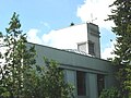
 The Orthodox Church | |
 Ostojićevo  Ostojićevo  Ostojićevo | |
| Coordinates: 45°53′17″N 20°10′00″E / 45.88806°N 20.16667°E | |
| Country | |
| Province | |
| Region | Banat |
| District | North Banat |
| Municipality | Čoka |
| Elevation | 88 m (289 ft) |
| Population (2011) | |
| • Ostojićevo | 2,844 |
| Time zone | UTC+1 (CET) |
| • Summer (DST) | UTC+2 (CEST) |
| Postal code | 23326 |
| Area code | +381(0)230 |
| Car plates | KI |
Ostojićevo (Serbian Cyrillic: Остојићево, Hungarian: Tiszaszentmiklós) is a village in Serbia. It is situated in the Čoka municipality, North Banat District, Vojvodina province. The village has a Serb ethnic majority (56.15%) with a present Hungarian minority (26.51%) and its population numbering 2,844 people. The village also has a Polish minority of about 300 people, of Cieszyn Silesian (mostly from Wisła) descent (2002 census).
Name[edit]
In Serbian the village is known as Ostojićevo (Остојићево), in Hungarian as Tiszaszentmiklós, in Slovak as Ostojičovo, in Croatian as Ostojićevo, and in German as Sankt Nikolaus an der Theiß.
Historical population[edit]
- 1961: 4,024
- 1971: 3,678
- 1981: 3,395
- 1991: 3,040
See also[edit]
References[edit]
- Slobodan Ćurčić, Broj stanovnika Vojvodine, Novi Sad, 1996.
Gallery[edit]
-
 The Saint Joseph Catholic Church.
 -
 The Evangelical church.


Wikimedia Commons has media related to Ostojićevo.
| International | |
|---|---|
| National | |
This North Banat District, Vojvodina location article is a stub. You can help Wikipedia by expanding it. |