
Monmouth Cemetery
| Monmouth Cemetery | |
|---|---|
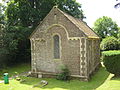
 The former chapel of rest in the Cemetery, built in 1851 | |
 | |
| Details | |
| Established | 1 December 1851 |
| Location | Osbaston Road, Monmouth |
| Country | Wales |
| Coordinates | 51°49′11″N 2°42′54″W / 51.8196°N 2.7150°W |
| Owned by | Monmouthshire Council |
| Size | 7 acres (2.8 ha) |
Monmouth Cemetery is a cemetery located at Osbaston Road, Monmouth, Wales. It was available for burials between 1852 and 2012.
History[edit]
Monmouth Cemetery was opened on 1 December 1851. The ground was consecrated on 23 June 1852 by the Bishop of Llandaff with the vicar of Monmouth, the Reverend E. F. Arney. The first burial took place on 25 June 1852.[1] The first ashes to be interred, in February 1930, were those of Reverend Kean Mottram Pitt, who died aged 70 on the Isle of Wight, and were placed in his parents' grave.[2]


The cemetery came into existence because Monmouth Council had decided to close St Mary's Churchyard in Monmouth for burials as decaying human remains were appearing above ground. This was caused by the raised height of the churchyard. Residents in neighbouring Whitecross Street suffered a high mortality rate as a result and unpleasant odours from the churchyard were also evident[1]
Henry Somerset, 7th Duke of Beaufort sold the land to the council for use as the new cemetery. The cemetery has been enlarged several times and now covers about 7 acres (2.8 ha). Monmouth Union Workhouse (opened 1870) and Haberdashers' Monmouth School for Girls (1897) are nearby. Because of its proximity to Monmouth workhouse an area of the cemetery, currently used for cremated remains, was designated for use of the paupers. The Paupers' Graves are mostly unmarked however in 1909 a hooded wooden cross was set in stone and unveiled. It is inscribed in Latin with Ave Crux Spes Unica meaning 'Hail, O Cross, Our Only Hope'.[3] The site is now owned and maintained by Monmouthshire County Council.[1]
There is a small former chapel of rest at the cemetery, designed by Rev. M. Wyatt and built by Charles Jackson[3] in 1851.[4] It was closed to the public about 1969,[5] but restored in 2010 and, following a celebratory opening on 26 June 2010, is now used as a genealogy centre.[6]
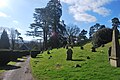
The cemetery is open all hours with open access and parking. Its hillside situation means that some of its paths are quite steep.[7] In 2012 the cemetery closed for new burials due to lack of space.[8]
Facilities[edit]
- Three water points, placed at intervals on the path network.[7]
- Limited parking at the chapel, mid-way and at the top of the cemetery.[7]
Notable interments[edit]
- William Wilson Allen VC - served at the Battle of Rorke's Drift; died 12 March 1890 of influenza[9]
- Mary Ellen Bagnall Oakeley - local artist and antiquarian
- Dr. Alfred Edwin Monahan - third bishop of Monmouth; died 10 August 1945[10]
- The Commonwealth War Graves Commission maintain and register the war graves of eight British service personnel of World War I (seven of them soldiers of the Royal Monmouthshire Royal Engineers) and six from World War II.[11]
Gallery[edit]
-
 Rear of the chapel
 -
 Grave of William Wilson Allen VC
 -
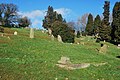 View of the cemetery from the lower road
 -
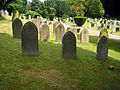 Sloping land sold to the council. Foreground headstones are of soldiers of the Royal Monmouthshire Royal Engineers, from World War I
 -
 View towards the former workhouse on the hill
 -
 View towards the town from near the top
 -
 View towards the town from near the bottom
 -
 View towards the chapel from halfway up the hill
 -
 Looking towards the North East - Hereford Road


References[edit]
- ^ a b c "History of Monmouth Cemetery". Monmouthshire County Council. Archived from the original on 28 September 2011. Retrieved 27 February 2012.
- ^ David Harrison, "Monmouth Cemetery, Trail 1", June 2008, p.5
- ^ a b David Harrison, "Monmouth Cemetery, Trail 1", June 2008, p.4
- ^ Keith Kissack, Monmouth and its Buildings, Logaston Press, 2003, ISBN 1-904396-01-1, p.88
- ^ "Monmouth chapel restoration begins". The South Wales Argus. Retrieved 27 February 2012.
- ^ "Monmouthshire County Council Newsletter Summer 2010". Monmouthshire County Council. Archived from the original on 1 October 2011. Retrieved 27 February 2012.
- ^ a b c "About Monmouth Cemetery". Monmouthshire County Council. Retrieved 27 February 2012.
- ^ "No new graves at Monmouth Cemetery". Welcome to Monmouth. Retrieved 27 February 2012.
- ^ "Cpl. William Wilson Allen (1240 B Co. 24th Regiment)". www.rorkesdriftvc.com. Retrieved 27 February 2012.
- ^ David Harrison, "Monmouth Cemetery, Trail 1", June 2008 p. 9-10
- ^ [1] CWGC Cemetery Report.