
Module talk:Iraqi insurgency detailed map/Archive 3
| This is an archive of past discussions. Do not edit the contents of this page. If you wish to start a new discussion or revive an old one, please do so on the current talk page. |
| Archive 1 | Archive 2 | Archive 3 | Archive 4 | Archive 5 |
Jalawla
There is clear evidence that Jalawla is in the hands of both Peshmerga and Iraqi Army affiliated forces. One of the newest most clear sources is this (kurdish) video that physically shows the presence of shia forces inside Jalawla. Is there a "joint controle" label? There should be. The label will not need to specify how much of the town each force controles, just that they are both there (in most cases it is 50/50 or the superior force would have pushed the other out). Here is the video that I was talking about.
Mozad655 (talk) 17:41, 27 January 2015 (UTC)
- There is a small number of Shia militia in Jalawla. They are there temporarily. Their object is said to be destroying Sunni houses in two suburbs of the city. On the other hand, there are thousands of Peshmerga soldiers in Baghdad since many years ago. Should Baghdad be labelled joint too? Roboskiye (talk) 08:59, 28 January 2015 (UTC)
- I'd rather it was on who is actually in control. In my opinion, Baghdad is still under Iraqi gov control regardless of how many Peshmerge soldiers you have. If we label everybody who has a significant force but is fighting for another group, and did the same on the Syrian map, we'd have to have a new colour around Kobane for the Iraqi Kurds who are helping the Syrians Kurds. John Smith the Gamer (talk) 10:17, 28 January 2015 (UTC)
- Same should be applied to Jalawla. In contrary, in Kobanê on Syrian map, we see an unnecessary green dot. So many Anti-Kurdish double standards on these two maps. Roboskiye (talk) 10:34, 28 January 2015 (UTC)
I just believe that the map is very deceiving when it shows Jalawla as yellow, when in reality the situation is extremely tense as there are just as many shia millitia who unlike kurdish peshmerga in Kobane or Baghdad, DO claim controle. Also, what makes you think that there is only a "small number" of Shia millitia in Jalawla and that they are there "temporarily"? Mozad655 (talk) 16:29, 28 January 2015 (UTC)
- As for the rebels in Kobane, I know, Roboskiye, believe me I know. I'm going to ignore any green in that area (unless the rebels actually control the village/city by themselves) when shading because otherwise it's going to give a very misleading impression. John Smith the Gamer (talk) 18:40, 28 January 2015 (UTC)
- One solid colour does not mean who controls the 'city' or 'village' that wouldn't make geo-political sense. The point of 2 colours is to show that there are 2 groups operating in this city/village. that might mean that the Iraqi forces control 2 or 3 neighbourhoods in this village and the Peshmerga controls 5 or 6 neighbourhoods. In split ethno-religious communities you will not see one dominant group control the ENTIRE city/village. So the dominant group does not really matter in the 2 or 3 neghbourhoods that another group controls. Look at Qamishli and Hasaka in the Syrian map, YPG controls 'x' amount of neighbourhoods and Assad control 'y' amount of neighbourhoods ... it would be improper to label the two cities entirely red or entirely yellow. Malik Danno (talk) 20:16, 29 January 2015 (UTC)
- As for the rebels in Kobane, I know, Roboskiye, believe me I know. I'm going to ignore any green in that area (unless the rebels actually control the village/city by themselves) when shading because otherwise it's going to give a very misleading impression. John Smith the Gamer (talk) 18:40, 28 January 2015 (UTC)
- So if I understand you correctly, Malik Danno, you are also FOR a mixed label where nessescary? I think Qamishli is a great example from the Syria template map. Because there are both Syrian Army forces and YPG forces in Qamishli, and both claim controle, Qamishli has been marked with a mixed label. I see no reason why the same mixed label should not be applied to Jalawla. The current label for Jalawla is very deceiving.
- Yes I am for a mixed label in cities/towns that have some neighbourhoods controls by one faction and other neighbourhoods controlled by another. I think it is geo-politically incorrect to assume that all cities/towns are one homogenous units. I am not sure about Jalawla, but if you have proof that some within the Baghdad Government/allies are inside some neighbourhoods of Jawala, then by all means change it. Malik Danno (talk) 15:40, 30 January 2015 (UTC)
- Let us point out then that only towns with two factions who BOTH claim controle, can be changed to mixed label. Towns such as Kobane where there are other factions like the FSA and peshmerga and who operate under the authority of the YPG and do NOT claim controle, should NOT be changed to mixed label. The whole point of the mixed label is to show who is in controle, not who is there and the two are not always the same. Does this make sence to everybody? Mozad655 (talk) 16:43, 30 January 2015 (UTC)
- It really doesn't matter who claims control of the city/town. My point is that we should not assume a city is a homogenous unit but a unit made up of many neighbourhoods. Now if Peshmerga control the city centre and 60% of the rest of the city and the Shi'a militia does not control the city centre but still controls 40% of the city centre (through control of different neighbourhoods) then we should label it as such (mixed colours). This is the most correct way to go about things. The reason is simple ... when down the line there is a battle in Jawala between Shi'a and Peshmerga and the colour was mixed on this map then it would make sense why there are clashes in the city, however if we make the colour solid now and then 2 weeks from now we see clashes between Shi'a and Peshmerga it wouldn't make any sense because there would be questions of how Shi'a went in? How they entered the city? and how did they get through the peshmerga chekpoints? ,,, all those questions will be irrelevant because the Shi'a militia were always there ... hence why it should be mixed. Mozad665, discussing what is wrong with Kobane here won't do anything for you, you should go to the talk page in the Syrian map. But my assumption is that they did that because the FSA does patrol and function inside the city and they still maintain a presence inside the city and provide security. Malik Danno (talk) 17:02, 30 January 2015 (UTC)
Well fighting can break out in any way. I don't think people will ask those questions if shia millitia fight peshmerga at some point. Shia could get in through fighting. They enter through fighting and got through the checkpoints through fighting. So altthogh I agree with you on the need for mixed labels, my reasons are mostly to show the situation as it is and not so much about what potential it has in terms of starting conflicts in the future. Regarding Kobane, I know this isn't the place to complain about the Kobane, but my point was that we should not make the same mistake on this map. Regarding the criteria for mixed label, I still believe that only towns where different factions BOTH claim controle, should be changed. If one faction does NOT claim controle, then why should we label it as such? Mixed labels only make sence if there is a dispute over controle. This comes back to the fact that my reasoning for mixed labels is all about showing the current situation, and not "explaining" conflicts that may or may not happen in the future. Mozad655 (talk) 19:30, 30 January 2015 (UTC)
- Its the "claiming" control that is confusing me. So a question for you, what if one faction claims control of the city and another does not claim control of the entire city centre but claims control of 'x' & 'y' neighbourhoods in the city ... what do you suggest in that case? Malik Danno (talk) 20:47, 30 January 2015 (UTC)
It doesn't matter if they claim only certain neighbourhoods or the entire town. If two sides are in dispute, regardless of whether it is over the entire town or only parts of it, then there is a dispute and disputes should be marked with mixed label. I see your point though and it would be nice to have a more detailed map of the town in those cases showing that its not all of the town that is disputed. But there is no need for this yet as I don't think we have this problem anywhere. Usually they claim all or nothing. The disputed towns are not that big. Mozad655 (talk) 21:37, 30 January 2015 (UTC)
Concerning the 4 new villages added in Kirkuk Region
Villages were added to outline the border after request from other users for more dots in Kirkuk Region. Very few if any sources indicate who is in controle of each village (and many others in that area). The only indication is the 2011 Iraqi Insurgency map. In lack of sources we have to follow the consensus that is already accepted on that map. Do not just change the color of the dots for the sake of changing them. Mozad655 (talk) 00:52, 31 January 2015 (UTC)
- Which consensus are you talking about? The 2011 Iraqi insurgency map derives from this map, you cant' use it as a source in a recursive way! The areas where there are no points have been marked averaging the distances between the places in which we have sources about their control, this doesn't mean that that map is accurate. The places you added near Hawija for istance are almost 100% in IS control, imho we can either edit them to black or remove them as long as we haven't direct sources --8fra0 (talk) 07:28, 31 January 2015 (UTC)
I know that map derives from this map. When we have no sources the marked averaging is all we have. How do you know that the places near Hawija are "almost 100% in IS control"? You say this like its undisputeable fact, but without providing any source. Your proposal to either edit the villages to black or remove them all together is extremely biased. The only neutral options are, 1) Follow the average line as shown on the 2011 Iraqi Insurgency map, 2) Assume that the villages are shared equally, or 3) remove them all together. Feel free to remove them all together, but making them all black or yellow without reason or souce is out of question. Mozad655 (talk) 17:30, 31 January 2015 (UTC)
- I know that the places near Hawija are almost 100% in IS control (at least until some days ago) because, if you check all the available sources and visual evidences, you can easily see that the frontlines in West Kirkuk are placed something like that because the Hawija plain is quite isolated from the rest of Kirkuk (there is a river in the north and a mountain in the east): http://wikimapia.org/#lang=en&lat=35.382612&lon=43.799057&z=11&m=b&gz=0;436043930;353659557;5568695;72788;4892349;814301;3004074;1909928;0;0&search=kirkuk There are no reports of Peshmerga having crossed Batiwa mount, most likely the actual frontline is placed a little east of that mount, where there is a channel/river. Near that place, until some weeks ago, there was the only open "border crossing" between IS and Peshmerga controlled Kurdistan, placed about here: http://wikimapia.org/#lang=en&lat=35.389190&lon=44.178643&z=15&m=bs&search=kirkuk --8fra0 (talk) 18:39, 31 January 2015 (UTC)
Those are your own specualtions and estimates based on your own interpretation of the geopgrahy. Good thing is that I have found a source that verifies your speculations This map. Feel free to change the color of the villages according to that map. I'm not sure about Kharap Rut and Mansoriyeh Kasabasi. I can't find Karap Rut on the geopgrahic map but it is most likely kurdish. This kurdish news report claim that the prisoners were captured near Kharap Rut. But feel free to change the color of the 3 main villages on the Hawija plan. Mozad655 (talk) 19:46, 31 January 2015 (UTC)
Semi-protected edit request on 31 January 2015
This edit request to Module:Iraqi insurgency detailed map has been answered. Set the |answered= or |ans= parameter to no to reactivate your request. |
remove
{ lat = "33.912", long = "44.441", mark = "map-arcEE-black.svg", marksize = "8", },
This was originally intended to show ISIS presence east of the town. But now ISIS is mostly gone from the Muqdadiyah region, so we can remove this now. 2601:0:B200:F7D9:79D3:86C:2E47:32F7 (talk) 02:24, 31 January 2015 (UTC)
2601:0:B200:F7D9:79D3:86C:2E47:32F7 (talk) 02:24, 31 January 2015 (UTC)
 Not done: please provide reliable sources that support the change you want to be made. —
 {{U|Technical 13}} (e • t • c)16:52, 1 February 2015 (UTC)
Here is the original edit: http://en.wikipedia.org/w/index.php?title=Module:Iraqi_insurgency_detailed_map&diff=next&oldid=639955899
This tweet from December 28, from a trusted source, shows ISF are clearing towns near this one: https://twitter.com/EjmAlrai/status/549199271271346176
This article details a suicide bombing in the town: http://www.salon.com/2014/12/30/is_group_claims_suicide_attack_in_iraq/
This tweet, from December 30, says ISF recaptured the town: https://twitter.com/thandojo/status/550348277799866369/photo/1
This tweet, from January 2, shows a photo of the Iraqi PM raising the flag in the town: https://twitter.com/brett_mcgurk/status/551038525051654144/photo/1
There is no reason for a siege icon to exist here. ISIS no longer controls towns in Muqdadiyah, so logically, it wouldn't be besieging the town anymore. I couldn't find any sources claiming it was besieged. 2601:0:B200:F7D9:ED96:280A:4E54:5A9F (talk) 17:21, 1 February 2015 (UTC)
4 villages near Hawija
This 4 villages are near Hawija which is in Isis controll but this 4 villages are shown Kurd controll,not olny that but there are mistakes for Aqulah(Alushah) place it is not near Islamiyah(Salamiyah) but near Al-Khan,And all are under Isis controll all southwestern places are in Isis controll.here,here,here.Lindi29 (talk) 15:13, 31 January 2015 (UTC)
- In this situation I totally agree with Lindi29 Hanibal911 (talk) 16:10, 31 January 2015 (UTC)
- A section has alreayd been made and we have agreed to change the color of those villages to black based on this this map. As for a mistake in location I don't see why. Both google map and wikimapia clearly show a small village called "al-Islamiyah" directly to the right of Aqulah. Al-Khan is further south west and its location is also correct. But I will remove al-Islamiyah. Its too small and there are other larger villages that are more noteworthy that show on the wikimapia map but not on google map. Mozad655 (talk) 19:53, 31 January 2015 (UTC)
- Kurdish sources like this http://awene.com/article/2015/02/01/38681 report Peshmerga has advanced and taken over 16 new villages south of Kirkik. Roboskiye (talk) 09:01, 1 February 2015 (UTC)
Thanks and a suggestion
This is a great project (and likewise the one for Syria). Would it be possible to add an option to view changes in territory over a specific period of time, to show which side is gaining territory? I think that would be very helpful for many people, otherwise you have to follow the situation manually and try to spot the change in dominance for each little point on the map. Ryn78 (talk) 20:55, 31 January 2015 (UTC)
- This is something I've looked into a bit, for the purpose of updating File:Iraq_war_map.png and similar maps. I came up with a couple of not great solutions. One of them is to save screenshots of the map and use picture difference with photo editing software. Another is to compare versions of the source code (Though note that maps of towns that have their own maps on the syrian modules will not work for this). One thing you can do is then create a map showing only the marks that have changed.
- As far as I know, there is no way to load past versions of a module, other than manually recreating them (e.g. in your sandbox). I'd also be interested if there is a way to load modules and files with 50% transparency. John Smith the Gamer (talk) 02:34, 1 February 2015 (UTC)
- This is definitely a feature that would make this map go a lot further in efficiently displaying the information it's trying to portray. If there is any way to do this, even if it's a sloppy one, I would totally be in favor of it. ArchPope Sextus VI (talk) 01:50, 4 February 2015 (UTC)
Baiji
There are new clashes in Baiji city between IS and ISF: http://www.presstv.ir/Detail/2015/02/06/396416/Iraqi-army-kills-70-militants-in-Baiji - http://www.iraqinews.com/iraq-war/security-forces-begin-operation-biji-70-isis-militants-killed/ --8fra0 (talk) 13:46, 6 February 2015 (UTC)
Beshir
I suggest we remove the village of Beshir all together for now. There is no fighting in Beshir and there are also no reports of any recent fighting. The current fighting label is especially wrong now that the labels everywhere else in Kirkuk have been changed back to yellow. For these reasons. I believe it is very clear that the current fighting label in Beshir is wrong and should not be there. Now we can either change the label to yellow or black. In lack of recent source for either force being in controle, the village should be completely removed until it is mentioned again in the media. There is no point having a village on the map when we don't know who is in controle, and where there are no reports of any ongoing or recent fighting. Mozad655 (talk) 07:25, 7 February 2015 (UTC)
Guideline to adding villages
I notice that there are are some places on the map where villages have been added so close to eachother that they almost form a straight line. Can we avoid these? They make it very hard to differentiate between the different areas and add a whole lot of mess to the map. There is no need to add villages that are right next to each other unless specific events have taken place in each one.
Smaller insignificant villages should also be replaced with larger villages. For example the villages in the Hawija area, where the villages added are very very small while there are other larger ones that are not on the map. Mozad655 (talk) 16:24, 13 February 2015 (UTC)
Batnaya
Batnaya is not Peshemerga controlled, but still under ISIS (unfortunately.) In fact this hasn't changed since the Peshmerga drew the line between Batnaya and Tel Isqof. I don't have any article about Batnaya being under which hands, but I was in Baqofah, last week to see the ISIS flag being flown from Batnaya myself. So can you please changed Batnaya to black. Thanks. Chaldean (talk) 08:56, 8 February 2015 (UTC)
I'm pretty sure you need to provide source that it is not peshmerga controlled. You provided no source in your change. Seeing it with your own eyes is not a valid source by any means. Mozad655 (talk) 10:59, 11 February 2015 (UTC)
- Where is the source that says it is peshmerga controlled? No source is not valid either. Chaldean (talk) 14:59, 14 February 2015 (UTC)
Zanqi
Zanqi was changed to fighting a few days ago which was correct based on this source. However, there has not been any reporting of any fighting since nor has there been any reports of ISIS taking the village. This can only mean that the attacks were repelled, which makes sence as the article also mentioned that "peshmerga forces immediately responded to the attacks". If someone would change Zanqi to yellow again it would be great. (I cannot do it because I have already reverted the edit of a pro-ISIS user and I am not sure if manual editing will count as an revert or not). Mozad655 (talk) 19:31, 13 February 2015 (UTC)
Also notice no mention of any fighting or ISIS takeover in Zanqi on this very trustworthy map. Mozad655 (talk) 13:46, 14 February 2015 (UTC)
- Mozad655 this doesn't mean anything beacause there are other towns that fight for a year and you change it back only they say responded fast ? They didn't clarify if it was captured or not so we cant change just on your opinion and also this blogspot as it say doesn't say anything for this village beacause it doesn't have any information.And you cant change it without reaching consensus first.Lindi29 (talk) 21:16, 14 February 2015 (UTC)
- The towns that "fight for a year" are major towns where there are frequent reports. Zanqi is not a large town and there has never been any reports about it until now. In other words, Zanqi is not Sinjar. The source did not reveal if it was captured by ISIS or not, it only said that peshmerga responded immediately. If the townw as taken by ISIS then we would've heard of it. We would've also heard about it if there was any recent fighting. The source I provided reports on all activities. The fact that they did not mention Zanqi is because there has not been any fighting there since. So changing Zanqi back was not an oppinion but the most reasonable thing to do based on evidence and sources. Your not in position to lecture me about changing without consensus. This is your signature. Mozad655 (talk) 23:36, 14 February 2015 (UTC)
- The same thing applies to many towns in Anbar marked as contested. I'm pretty sure that there are no clashes in Abu Grahib and Amiriyat al Falluja since months, for istance. But I think that it's difficult to find sources stating that there are NO clashes there --8fra0 (talk) 08:29, 15 February 2015 (UTC)
- But if we start labelling all small villages and large towns where there has been activity in the past as contested, then the whole map will end up contested. Because as you say, it is difficult to find sources that back to specific villages and towns and says fighting has ended. The media does not report on peace but on violence. The only thing we can do is safely ASSUME that it is no longer contested since nobody is reporting on it anymore. Anyways feel free to change, I strongly disagree but this is a democracy. Mozad655 (talk) 13:02, 15 February 2015 (UTC)
- Mozad655 look the syrian war map and see small villages are contested for months or years I didn't say to change it yellow or black I was according to the source when It said they responded fast but didn't say they captured or losed so clashes continued on this village.I am not teaching you anything I am reminding you the rules.Also blogspot is not the only source who reports for this war we have other reliable sources.Lindi29 (talk) 15:24, 15 February 2015 (UTC)
- Well I don't think you should use another bad example on another map as reason to continue making the same mistake. I think the problem here is that we disagree on what is default and what we fall back on when no new reports are comming in. IMO when in doubt you fall back and change to whoever was in controle the last time, unless frequent reports of fighting come in or until a report comes out that says the opposite force has taken over. The source in this case, said fighting continued in another village as peshmerga were shelling it. It did not say that fighting continued in Zanqi. But even if we say that fighting continued in Zanqi at that point in time, that is no reason to keep the town as contested for weeks and months to come until someone reports that there is actually no fighting there and the attacker did not gain any territory 2 months earlier. These kind of reports are very rare as the media most often only talks about the start of a battle and not the outcome if the outcome is just a continuation of the previous status quo. But again. If you insist then feel free to change now that we have discussed it on talk page. I still believe it is wrong and deceiving, but democracy is democracy. Mozad655 (talk) 17:32, 15 February 2015 (UTC)
Sinjar not contested anymore?
According to this CNN source from today, ISIS is in complete controle of Sinjar and peshmerga don't seem interested in retaking it. Only occasional airstrikes and assaults to stop the traffic road from Syria to Iraq through Sinjar. 87.52.35.207 (talk) 17:26, 16 February 2015 (UTC)
- I think leaving it as contested is appropriate for now, almost everywhere else the reports seem to suggest progress is slow but that there certainly is a peshmerga presence in Sinjar town. Akerbeltz (talk) 19:27, 16 February 2015 (UTC)
Al-Walid Crossing Siege Line?
Is that a siege line at Al-Walid Crossing? If so, we need to make it more visible. You can barely see it because it blends in with the border line and crossing symbol. I only noticed it because a black mark is visible against the grey border. Will someone please look into that? If it isn't supposed to be there, please remove it. Anasaitis (talk) 00:05, 17 February 2015 (UTC)
Tuz Khurmato?????
1- why the heck does it show iraqi government(shia militia) is inside tuz khurmatu??????? 2- plus can someone change the name from taza khurmatu to tuz khurmatu because taza is bloody wrong! -Sarwar2000
There are two towns. One is called Taza Khurmatu and the other is called Tuz Khurmatu. The one near Kirkuk is Taza Khurmatu. There are shia millitia inside Taza Khurmatu according to many sources. For example this UK source or this source from Yahoo. Mozad655 (talk) 00:15, 21 February 2015 (UTC)
Whoever changed Taza Khurmatu without talking about it here first, needs to change it back. If someone else can do it then even better. Mozad655 (talk) 08:40, 22 February 2015 (UTC)
Kar Mardy
Can anyone give a source that says Kar Mardy is under ISIS? It does not seem right. I have not noticed it before. Did someone just add it? If its not wrong then Kan'Us must be wrong. Does anyone have a source for that one being under peshmerga? Mozad655 (talk) 15:55, 20 February 2015 (UTC)
- Mozad655 this is the source that was provided for this village.here.Lindi29 (talk) 23:27, 21 February 2015 (UTC)
- Thank you for that. It just said coalition airstrikes also targeted the village of Kar Mardy, Nasrallah and Sultan Abdullah. This does not mean that the town was captured by ISIS. Airstrikes can happen mid battle. Sultan Abdullah we know for sure is 100% peshmerga and it is also listed there. It should be changed back, until a reliable source specifically says that it is captured. Mozad655 (talk) 08:11, 22 February 2015 (UTC)
- Lind please don't start again. The source is reliable but the source does not say that the town was captured by ISIS. It just says airstrikes. And just as there were airstrikes in Sultan Abdullah but Sultan Abdullah is still under peshmerga, the same goes for Karmardi. Airstrikes took place as ISIS attacked. Work with me for a second. Mozad655 (talk) 15:04, 22 February 2015 (UTC)
- Mozad655 You have to understand that if they attack that doesn't mean they withdraw from they position they draw from those position they attacked and those position that they attacked were peshmerga positon but anyway i will wait for more sources for this villages, as for Karmardi leave it for now just as it is.Lindi29 (talk) 15:38, 22 February 2015 (UTC)
- Your argument doesn't make any sence. I don't understand your point. Sultan Abdullah was also mentioned. But we know for sure that Sultan Abdullah is under kurdish controle. Why are you assuming something different for Karmardi? Airstrikes is NOT the same as ISIS capturing the village. Airstrikes are normal during battles. In Sultan Abdullah there were airstrikes on ISIS during the battle, and peshmerga kept controle of Sultan Abdullah and pushed ISIS out. Same for Karmardi. Whatever grudge you have against the kurdish people, you need to put aside. There is no proof what so ever that Karmardi was taken by ISIS. Mozad655 (talk) 15:48, 22 February 2015 (UTC)
- LOL Mozad655 I just edited with a reliable source I dont have anything against anybody the source clearly says that attacked Isis position in this villages but it didn't says it pushed out or captured those position like I said learn to read carefully the sources word by word and you said work with me ,I will but I see you dont have any intention to work beacause you want to edit like you are the source here beacause you know everything like Sultan Abdullah village where the source says airstrikes but you say that there are no Isis members in it?so they are attacking Peshmerga position in it ,and where is that source that is says there aren't?No where, just your words, thing doesn't work like this here with words only with reliable sources.Lindi29 (talk) 17:02, 22 February 2015 (UTC)
You still don't get it. I am not disputing whether the source is reliable or not. The source does not say that Karmardy is taken by ISIS. Airstrikes attacked ISIS positions in this village, but that does not mean that ISIS is still there. Other sources have said that all attacks were repelled, this means ISIS was pushed out again by peshmerga and airstrikes. Again, look at Sultan Abdullah. There were airstrikes there too, but we know it is under peshmerga today. You always interpret the sources and when you are in doubt you go pro-isis. Yes there are no ISIS members in Sultan Abdullah but there were airstrikes. Airstrikes does not prove that they are in there, it proves that they WERE. Do you see the difference between past and present? Here are the sources that say Sultan Abdullah is under kurdish controle DESPITE airstrikes (you still need to get into your head that airstrikes can be used to defend, not just attack). http://www.mcclatchydc.com/2015/02/22/257430/at-kurdish-front-line-outpost.html or this http://www.bbc.com/news/world-middle-east-31524867 and there are many other sources that say ISIS captured no land. Mozad655 (talk) 16:52, 23 February 2015 (UTC)
Editing links
I want to change "Al Baghdadi"'s link to Khan al-Baghdadi. Discuss-Dubious (t/c) 02:35, 23 February 2015 (UTC)
Sure go ahead. I think its better to use that variant because the leader's name is also "Al Baghdadi". Mozad655 (talk) 16:53, 23 February 2015 (UTC)
- I can't edit it properly, though. It won't let me fix lines. Discuss-Dubious (t/c) 12:58, 25 February 2015 (UTC)
Towns near Mosul edited without sources
I noticed that in the past days a couple of towns near Mosul have been edited to IS controlled without providing any source. The towns are Darnajukh in north Mosul and Al Khidir in south Mosul. Today a reliable source https://twitter.com/EjmAlrai/status/569813128311128064 is reporting that Kurds are a mere 10 km north of Mosul. --8fra0 (talk) 11:22, 23 February 2015 (UTC)
- I wondered about that a little, all this media coverage seems to suggest that the Kurds are advancing on Mosul. Banak (talk) 11:31, 23 February 2015 (UTC)
The source used is this map from a random twitter account called "le_carabinier" that has no credentials. As you can see on the map the area on the right side of Badush Dam is all unclear and disputed. Darnajukh is in the middle of that disputed area and since it was originally yellow, it should not have been changed to black as the area is unclear according to this very source that the editor used. But the editor, Lind29, is well known for always giving ISIS the benifit of the doubt even if it means switching colors. As for Al-Khidir, it is clear ISIS territory according to this map. I suggest we keep Al-Khidir black and change Darnajukh back to yellow, as the source provided does not claim that area to be under ISIS. Mozad655 (talk) 17:45, 23 February 2015 (UTC)
- Mozad655 Do you have something against my edits?Like I said I am neutral editor but for you I cant say the same according to many wrong edits that you do without reading clearly the source,as for "le_carabinier" so you accept that source Ok,as for Darnajukh if you see clearly because we know that you have a problem reading and watching clearly sources also changing they words what they say ,the source of "le_carabinier" clearly puts this village in Isis held territory but like always you go on with your own opinion not with the source.Lindi29 (talk) 16:51, 24 February 2015 (UTC)
- Well you "say" you are neutral but your edits speak for themselves. It is obvious that you always favor ISIS whenever there is any doubt. What wrong edits did I make? I edit in all directions not just pro-isis edits. But you seem to only edit in favor of ISIS and in most cases you have no source. You ASSUME that ISIS must be in controle whenever there is any shred of doubt or lack of information instead of just leaving it. As for Darnajukh this is just another example of how pro-ISIS you are. Look at the twitter map. Now notice the triangle next to Badush Dam. Follow the river down to the spot below where it starts turning right. There is an Island. Darnajukh is between the triangle above and the Island below, which puts it well into the red "disputed/unclear" area. The fact that you cannot see that goes to show how incredibly biased and pro-ISIS you are. Mozad655 (talk) 17:05, 24 February 2015 (UTC)
- Mozad655 I dont have sources? I always edit with reliable source not like you with biased source,Now i got you I proved that you are pro-kurd now you say that the red shows that it is disputed means contested,after accepting this source you went and said that al-khidir is Isis held but Darnajukh is Kurd held and now you are saying the oppsite,I proved now that you are biased editor,my plan changing this village Is held proved that you are a biased editor.Lindi29 (talk) 15:25, 25 February 2015 (UTC)
Your confused buddy. I don't even understand your english anymore. Write like a normal person. Mozad655 (talk) 17:20, 25 February 2015 (UTC)
Semi-protected edit request on 26 February 2015
This edit request to Module:Iraqi insurgency detailed map has been answered. Set the |answered= or |ans= parameter to no to reactivate your request. |
change
{ lat = "32.040", long = "42.255", mark = "Location dot black.svg", marksize = "6", label = "Nukhayb", link = "Nukhayb" },
to
{ lat = "32.040", long = "42.255", mark = "Location dot red.svg", marksize = "6", label = "Nukhayb", link = "Nukhayb" },
sources:
http://www.understandingwar.org/sites/default/files/ISIS%20Sanctuary%20Map%20JAN.%2015.%202015.pdf
http://www.reuters.com/article/2015/01/05/us-mideast-crisis-saudi-idUSKBN0KE0G420150105
http://al-shorfa.com/en_GB/articles/meii/features/2014/08/26/feature-01
2601:0:B200:F7D9:C873:A79E:4700:26E8 (talk) 13:34, 26 February 2015 (UTC)
Who controls Nukhayb?
There were reports in June that said ISIS took over Nukhayb:
http://www.wsj.com/articles/sunni-insurgents-capture-more-territory-in-western-iraq-1403428664
These reports from later, in August and January, respectively, claim that Nukhayb was retaken and held by Iraqi forces:
http://al-shorfa.com/en_GB/articles/meii/features/2014/08/26/feature-01
http://www.reuters.com/article/2015/01/05/us-mideast-crisis-saudi-idUSKBN0KE0G420150105
This ISIS Sanctuary Map from a reliable source in January shows no ISIS presence whatsoever in Nukhayb:
http://www.understandingwar.org/sites/default/files/ISIS%20Sanctuary%20Map%20JAN.%2015.%202015.pdf
I think that based on these sources, including a reliable source (Institute for the Study of War), Nukhayb should be changed to government-controlled. Thoughts? 2601:0:B200:F7D9:B14B:AA4B:64E7:8A62 (talk) 02:54, 23 February 2015 (UTC)
Sure. Change it. The reuter source is pretty clear and trustworthy. Mozad655 (talk) 15:56, 24 February 2015 (UTC)
I don't have edit privileges, so someone else must do it. Sadly, this means for this map http://en.wikipedia.org/wiki/File:Syria_and_Iraq_2014-onward_War_map.png the Iraqi desert has been wrongly marked as ISIS for 6 months. 2601:0:B200:F7D9:8CD4:D21B:E9B4:507B (talk) 12:22, 26 February 2015 (UTC)
- Well, I look a little silly now. Thanks for noticing it. Also, you might want to look at Wikipedia:Edit_requests. Banak (talk) 12:48, 26 February 2015 (UTC)
OK. Edit request submitted. 2601:0:B200:F7D9:C873:A79E:4700:26E8 (talk) 13:38, 26 February 2015 (UTC)
Taza Khurmatu, Daquq, Tuz Khurmatu and Jalawla.
Source for shia millitia base outside Taza: Source1. Source2
Source for shia millitia base outside Daquq: Source3
Source for shia millita inside and around Tuz Khurmatu: Source4. Source 5
Source for shia millita inside and around Jalawla: Source6 Mozad655 (talk) 18:20, 26 February 2015 (UTC)
Semi-protected edit request on 12 February 2015
This edit request to Module:Iraqi insurgency detailed map has been answered. Set the |answered= or |ans= parameter to no to reactivate your request. |
change
{ lat = "35.235", long = "43.890", mark = "Location dot black.svg", marksize = "6", label = "Riyadh", link = "Riyadh", label_size = "0", position = "bottom" },
to
{ lat = "35.235", long = "43.890", mark = "80x80-yellow-black-anim.gif", marksize = "6", label = "Riyadh", link = "Riyadh", label_size = "0", position = "bottom" },
source:
http://www.understandingwar.org/backgrounder/iraq-situation-report-february-10-11-2015
A besieged icon could also work. 2601:0:B200:F7D9:6DAF:AF66:3742:F250 (talk) 00:46, 12 February 2015 (UTC)
I think we need a couple more soures to verify this. The map said peshmerga and other forces came from Baiji, but there are no reports of peshmerga ever being in Baiji. Riyadh is the middle of ISIS' heartland in Kirkuk province and it is too big of a change for us to mark it as contested or besieged, based on one source only. Mozad655 (talk) 04:39, 18 February 2015 (UTC)
- Not done: please provide reliable sources that support the change you want to be made. —
{{U|Technical 13}} (e • t • c)00:55, 1 March 2015 (UTC)
Edit war over militia
Will you give it a rest with your POV pushing? Even Kurdish sources openly admit to the presence of Arab militia along the Hamrin line such as Rudaw here here and Ekurd here. Like it or not (I happen to think it's a dangerous move), they're there. Akerbeltz (talk) 23:24, 28 February 2015 (UTC)
I have reported Alan Genco and JapanerRusse and they are now both blocked for 48 hours. If they continue I predict a long term ban. But they did make a good point about possible kurdish forces in Sadiya, Amirli, Sulaiman Bek. I know kurdish forces took part in recapture of these towns but I don't know if they remained. I will look into it and will add kurdish center labels in those towns if I find enough refs. Mozad655 (talk) 11:47, 1 March 2015 (UTC)
Al-Baghdadi
ISIS has just taken Al-Baghdadi. Source: http://www.cnn.com/2015/02/13/middleeast/isis-iraq/index.html 76.99.189.128 (talk) 15:52, 13 February 2015 (UTC)
- Last sources state that the fight is still going on and IS mostly repelled: http://news.xinhuanet.com/english/world/2015-02/14/c_133996093.htm --8fra0 (talk) 14:04, 14 February 2015 (UTC)
The source is clear. Feel free to change al-Baghdadi back to contested. Mozad655 (talk) 15:30, 14 February 2015 (UTC)
http://basnews.com/en/news/2015/02/15/iraqi-army-re-take-baghdadi-town-in-anbar-province/ Mozad655 (talk) 19:22, 15 February 2015 (UTC)
http://www.euronews.com/2015/02/24/iraq-army-steps-up-campaign-against-isil-in-al-baghdadi/ WaunaKeegan11 11:13, 2 March 2015 (UTC) Iraqi Security Forces have retaken the town from ISIS and the militants are retreating from the town.
- WaunaKeegan11 Source Euronews not said that Iraqi army recaptured town of Al Baghdadi. Source just said that Iraqi army has stepped up efforts to retake the town of al-Baghdadi from ISIL. Hanibal911 (talk) 17:25, 2 March 2015 (UTC)
Battle of Tikrit
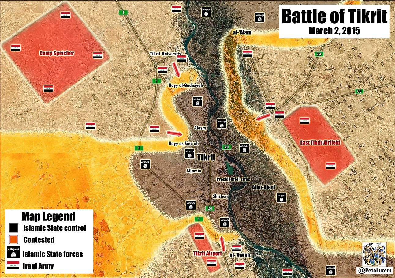
So the battle for Tikrit has started. Government and Shi'ite militia forces are surrounding the city. Pro-government source Peto Lucem reports here https://pbs.twimg.com/media/B_HfVVVW8AEyZot.jpg:large that government forces and ISIS are fighting inside al-Alam, but we will have to wait for further confirmation from an unbiased source before we make the edit. I would also watch Albu Ajil, as it may become contested or captured soon. For your benefit, reliable sources include http://www.understandingwar.org/ and https://twitter.com/EjmAlrai.2601:0:B200:F7D9:50F0:8231:62E5:6024 (talk) 21:17, 2 March 2015 (UTC)
Semi-protected edit request on 3 March 2015
This edit request to Module:Iraqi insurgency detailed map has been answered. Set the |answered= or |ans= parameter to no to reactivate your request. |
change
{ lat = "34.456", long = "43.794", mark = "80x80-red-black-anim.gif", marksize = "6", label = "Ad Dawr", link = "Ad Dawr", label_size = "0" },
to
{ lat = "34.456", long = "43.794", mark = "Location dot red.svg", marksize = "6", label = "Ad Dawr", link = "Ad Dawr", label_size = "0" },
source: http://www.understandingwar.org/backgrounder/iraq-situation-report-march-2-2015
ISW is a reliable source and 'Al-Dour' is the same as 'Al-Dawr'. 2601:0:B200:F7D9:5C95:D6B4:1568:5C25 (talk) 12:44, 3 March 2015 (UTC)
According to many articles from just a couple of hours ago the offensive of ad-dawr is still going on so i don't think your suggestion is valid. https://news.google.com/news/story?pz=1&ned=us&hl=en&ncl=dgVqlrHgBaP00iMzYp53nNKC_rMZM&lr=en&rfilter=0&q=dawr&btnC=Go Spenk01 (talk) 13:07, 3 March 2015 (UTC)
This report, saying it is contested, is from March 2:
http://m.bbc.com/news/world-middle-east-31699632
These reports, saying it was captured, are from March 3:
http://news.xinhuanet.com/english/2015-03/04/c_134034749.htm
2601:0:B200:F7D9:DC3B:D1D4:DFFA:55F7 (talk) 23:04, 3 March 2015 (UTC)
Al jazeera source was legit Spenk01 (talk) 16:47, 4 March 2015 (UTC)
Ghazlani training camp ceased to exist
ISIS has destroyed Ghazlani traning camp south of Mosul. It does not exist anymore. Should be removed.
- http://tvbaghdad.net/News.aspx?NewsId=10948#.VPctb_nF870
- http://www.iraqpressagency.com/ar/2015/03/02/%D8%AF%D8%A7%D8%B9%D8%B4-%D9%8A%D9%81%D8%AC%D8%B1-%D9%85%D8%A8%D8%A7%D9%86%D9%8A-%D9%85%D8%B9%D8%B3%D9%83%D8%B1-%D8%A7%D9%84%D8%BA%D8%B2%D9%84%D8%A7%D9%86%D9%8A-%D9%88%D9%85%D9%82%D8%B1-%D9%82/
- http://www.dotmsr.com/details/%D8%AF%D8%A7%D8%B9%D8%B4-%D9%8A%D9%81%D8%AC%D8%B1-%D9%85%D8%B9%D8%B3%D9%83%D8%B1-%D8%A7%D9%84%D8%BA%D8%B2%D9%84%D8%A7%D9%86%D9%8A-%D8%AC%D9%86%D9%88%D8%A8-%D8%A7%D9%84%D9%85%D9%88%D8%B5%D9%84
- http://www.alarabiya.net/ar/arab-and-world/iraq/2015/03/02/%D8%B9%D8%B5%D8%A7%D8%A8%D8%A7%D8%AA-%D8%AF%D8%A7%D8%B9%D8%B4-%D8%AA%D9%81%D8%AC%D8%B1-%D9%85%D8%B9%D8%B3%D9%83%D8%B1-%D8%A7%D9%84%D8%BA%D8%B2%D9%84%D8%A7%D9%86%D9%8A-%D8%AC%D9%86%D9%88%D8%A8%D9%8A-%D8%A7%D9%84%D9%85%D9%88%D8%B5%D9%84-.html Roboskiye (talk) 16:11, 4 March 2015 (UTC)
- http://www.dotmsr.com/details/%D8%AF%D8%A7%D8%B9%D8%B4-%D9%8A%D9%81%D8%AC%D8%B1-%D9%85%D8%B9%D8%B3%D9%83%D8%B1-%D8%A7%D9%84%D8%BA%D8%B2%D9%84%D8%A7%D9%86%D9%8A-%D8%AC%D9%86%D9%88%D8%A8-%D8%A7%D9%84%D9%85%D9%88%D8%B5%D9%84
- There are reports that ISIS destroyed even Mosul airport and Qayyarah airfield. Roboskiye (talk) 16:27, 4 March 2015 (UTC)
- http://www.iraqpressagency.com/ar/2015/03/02/%D8%AF%D8%A7%D8%B9%D8%B4-%D9%8A%D9%81%D8%AC%D8%B1-%D9%85%D8%A8%D8%A7%D9%86%D9%8A-%D9%85%D8%B9%D8%B3%D9%83%D8%B1-%D8%A7%D9%84%D8%BA%D8%B2%D9%84%D8%A7%D9%86%D9%8A-%D9%88%D9%85%D9%82%D8%B1-%D9%82/
If you use arabic sources you need to provide translation and source for correct translation. Sources should be accessable to english speakers as this is wikipedia english, otherwise you could claim anything and nobody would be able to challenge your edit. I hope you understand. Mozad655 (talk) 09:46, 5 March 2015 (UTC)
Samarra
What is the source that Samarra is contested ? It is still under government control. If samarra is contested then you can also claim that Tikrit is contested too, because the governmemt is attacking ISIS in south-Tikrit. So do you have sources for Samarra ? — Preceding unsigned comment added by 83.117.35.11 (talk) 09:52, 14 January 2015 (UTC)
shia millitants forming in kirkuk airbases.
Iraqi government forming Shia militias in kirkuk and in kirkuk army bases
http://rudaw.net/english/middleeast/iraq/08012015 — Preceding unsigned comment added by 0ali1 (talk • contribs) 03:28, 17 January 2015 (UTC)
Al-Mada'in never under control of ISIS
Al-Mad'in is south east of Baghdad was never control of ISIS. It is under the control of the Iraqi Security Force. — Preceding unsigned comment added by 0ali1 (talk • contribs) 13:28, 17 January 2015 (UTC)
Semi-protected edit request on 7 March 2015
This edit request to Module:Iraqi insurgency detailed map has been answered. Set the |answered= or |ans= parameter to no to reactivate your request. |
change
{ lat = "33.404", long = "43.914", mark = "Location dot black.svg", marksize = "8", label = "Al-Karmah", link = "Al-Karmah", label_size = "0" },
to
{ lat = "33.404", long = "43.914", mark = "80x80-red-black-anim.gif", marksize = "8", label = "Al-Karmah", link = "Al-Karmah", label_size = "0" },
source:
http://www.understandingwar.org/backgrounder/iraq-situation-report-march-5-6-2015
Karmah is contested. It should be marked contested.
2601:0:B200:F7D9:55B:487E:F348:B074 (talk) 19:27, 7 March 2015 (UTC)
DoneSpenk01 (talk) 23:00, 8 March 2015 (UTC)
South Salahaldin Province
Can we confirm these towns Nebai, Sayed Gharib, Tarisha, Al Hawish, Mukayshafah, and Dijlah are still contested. I believe that most (if not all) have been reclaimed by the ISF. Malik Danno (talk) 17:56, 9 March 2015 (UTC)
I was thinking about this aswell. Some people have a habbit of being the first to mark a town as conested, but abandon the area afterwards and don't follow up with updates. I think most of the RedBlack contested towns are in fact under ISF. They have been labelled as contested for a very long time. Mozad655 (talk) 18:12, 9 March 2015 (UTC)
Semi-protected edit request on 2 March 2015
This edit request to Module:Iraqi insurgency detailed map has been answered. Set the |answered= or |ans= parameter to no to reactivate your request. |
change
{ lat = "34.931", long = "43.493", mark = "80x80-red-black-anim.gif", marksize = "12", label = "Baiji", link = "Baiji, Iraq", label_size = "75", position = "right" },
to
{ lat = "34.931", long = "43.493", mark = "Location dot red.svg", marksize = "12", label = "Baiji", link = "Baiji, Iraq", label_size = "75", position = "right" },
sources:
http://news.sky.com/story/1436941/iraqi-forces-launch-operation-to-recapture-tikrit
http://www.dailymail.co.uk/wires/afp/article-2976371/Fallen-IS-Iraqi-Syrian-towns.html
I don't know about the 2 towns south of Baiji that are marked as contested, but I think it would make sense to change them to red as well.
2601:0:B200:F7D9:50F0:8231:62E5:6024 (talk) 22:31, 2 March 2015 (UTC)
You're right baiji was captured in November but it seems like it never made it to this wiki page. Spenk01 (talk) 12:25, 3 March 2015 (UTC)
Baiji in december was retaken by IS...http://www.globaltimes.cn/content/897886.shtml ... then clashes re-erupted inside the city according previous statements of various sources including ISW...so, I think its right status is contested. Fab8405 (talk) 13:20, 3 March 2015 (UTC)
But according to this article : http://news.sky.com/story/1436941/iraqi-forces-launch-operation-to-recapture-tikrit "Backed by air strikes from the US-led coalition, Iraqi troops recently seized the nearby refinery town of Baiji." + this article is from Monday 02 March 2015 Spenk01 (talk) 13:26, 3 March 2015 (UTC)
Lindi29 Have you checked the date of the Skynews report before you reverted my changes?Spenk01 (talk) 16:55, 4 March 2015 (UTC)
On 9th February 2015, Iraqi Security Forces retake Baiji City. This proves that the Iraqi Security Forces had retaken the city. http://original.antiwar.com/updates/2015/02/08/149-killed-in-iraq-as-security-forces-claim-baiji-again/ (talk) 19:06, 9 March 2015 (UTC)
Semi-protected edit request on 9 March 2015
Change
{ lat = "33.926", long = "44.157", mark = "80x80-red-black-anim.gif", marksize = "6", label = "Sayed Gharib", link = "Sayed Gharib", label_size = "0", position = "top" },
to
{ lat = "33.926", long = "44.157", mark = "Location dot red.svg", marksize = "6", label = "Sayed Gharib", link = "Sayed Gharib", label_size = "0", position = "top" },
Sayed Ghraib is liberated from ISIS militants. It should be marked under government control.
- Found another report about it http://www.english.shafaaq.com/index.php/security/12755-security-forces-and-fighters-of-popular-crowd-liberate-northern-dujail-fully-and-head-towards-al-nibai so, done. Spenk01 (talk) 19:10, 9 March 2015 (UTC)
You can't use Iraqi sources to verify pro-Iraq edits. Its a well established rule and goes for all parties involved. Please change back and try to find non-Iraqi sources. Mozad655 (talk) 22:05, 9 March 2015 (UTC)
Second Semi-protected edit request on 9 March 2015
Change
{ lat = "34.087", long = "44.038", mark = "80x80-red-black-anim.gif", marksize = "6", label = "Tarisha", link = "Tarisha", label_size = "0", position = "top" },
to
{ lat = "34.087", long = "44.038", mark = "Location dot red.svgf", marksize = "6", label = "Tarisha", link = "Tarisha", label_size = "0", position = "top" },
Source: http://www.iraqinews.com/iraq-war/iraqi-forces-kill-27-isis-militants-free-two-areas-near-tikrit/
GRAPHIC: http://english.farsnews.com/newstext.aspx?nn=13931017001314
Tarisha is liberated from ISIS militants. It should be marked under government control.
- Done it since no other attacks were reported since Tarisha was liberated. Spenk01 (talk) 20:03, 9 March 2015 (UTC)
Again no Iraqi sources. Also Iranian sources are not reliable either for pro-Iraq edits. Just like we don't accept PYD kurdish guerilla sources for pro-peshmerga edits, we cannot accept Iranian sources for pro-Iraqi edits either. Both are are partial and sources are therefore ilegitimate for the edits that you have made. Try finding impartial sources (non Iraqi/Iranian). Mozad655 (talk) 22:08, 9 March 2015 (UTC)
- Mozad655 The problem is that IS doesn't announce defeat and that no other source will announce that the Iraqi army liberated a village that barely contains 100 houses. we can set villages from Iraqi army controlled to contested using pro iraq news but not put it back to iraqi army control when the same source reports the attack was repelled. Anyway if you don't think the sources that were used were legit then take a look at this map: https://pietervanostaeyen.wordpress.com/2015/03/02/iraq-map-update-dd-march-1-2015/ i can tell the editor of this map is not pro IA.
Peshmerga major offensive south of city Kirkuk
Peshmerga launch an attack in order to encircle and regain control of the areas surrounding to the city of Hawija and spend a most important ISIS strongholds to southwest of Kirkuk.Al Mayadeen Hanibal911 (talk) 13:50, 10 March 2015 (UTC)
- Here map showed villages which captured the Peshmerga during their offensive against ISIS near city of Kirkuk.here Hanibal911 (talk) 16:25, 10 March 2015 (UTC)
Semi-protected edit request on 10 March 2015
Change { lat = "34.368", long = "41.096", mark = "Location dot black.svg", marksize = "13", label = "Al-Qa'im", link = "Al-Qa'im (town)" },
to
{ lat = "34.368", long = "41.096", mark = "80x80-red-black-anim.gif", marksize = "13", label = "Al-Qa'im", link = "Al-Qa'im (town)" },
Source: http://www.presstv.ir/Detail/2015/03/09/400952/60-ISIL-militants-killed-in-western-Iraq
Al-Qaim town is contested. It should be marked contested.
- I'm sorry, but Press TV is too biased and is considered to be pro-Iraqi and staunchly anti-ISIS. No using pro-gov sources for gov advances nor pro-ISIS(at least on this map) for ISIS advances. Don't even bother using pro-Kurd source for Kurd advances. Do so and it will be revered if any editors here find out. Use only reliable resources. Rules are rules. And please sign your signature once you leave a message on a talk page.--Damirgraffiti |☺What's Up?☺ 23:05, 10 March 2015 (UTC)
I agree. Press TV is as good as Iraqi TV which we have already agreed isn't valid for pro-Iraq edits, just like YPG media isn't valid for pro-peshmerga edits. Mozad655 (talk) 23:57, 10 March 2015 (UTC)
Second Semi-protected edit request on 10 March 2015
change
{ lat = "34.931", long = "43.493", mark = "80x80-red-black-anim.gif", marksize = "12", label = "Baiji", link = "Baiji, Iraq", label_size = "75", position = "right" },
to
{ lat = "34.931", long = "43.493", mark = "Location dot red.svg", marksize = "12", label = "Baiji", link = "Baiji, Iraq", label_size = "75", position = "right" },
On 9th February 2015, Iraqi Security Forces retake Baiji City. This proves that the Iraqi Security Forces had retaken the city.
I think you need more sources for such a big edit. If Baiji was really captured, all media would mention it. Its also very unlikely that Baiji is captured by ISF before Tikrit now that all the effort is put into Tikrit. In other words, lets wait for more sources before we make any changes to a city the size of Baiji. Mozad655 (talk) 23:59, 10 March 2015 (UTC)
Eski Mosul and sorroundings
March 9th report of ISW states, in point 9, that IS captured in Badush area three former Iraqi soldiers of Saddam era and executed them in Eski Mosul...so, I think that shows as IS-held Eski and, obviously, the other Tigris's towns located between Badush and Eski( Dawasah, Musharraf Habit and Halabiya)...Fab8405 (talk) 02:36, 11 March 2015 (UTC)
Second Semi-protected edit request on 11 March 2015
Change: { lat = "33.404", long = "43.914", mark = "80x80-red-black-anim.gif", marksize = "8", label = "Al-Karmah", link = "Al-Karmah", label_size = "0" },
To:
{ lat = "33.404", long = "43.914", mark = "Location dot red.svg", marksize = "8", label = "Al-Karmah", link = "Al-Karmah", label_size = "0" },
Source: http://www.turkishweekly.net/news/181476/iraq-350-daesh-militants-killed-in-anbar-operation.html--0ali1 (talk) 19:02, 11 March 2015 (UTC)
Al Karmah SHould be marked as red.
Semi-protected edit request on 12 March 2015
This edit request to Module:Iraqi insurgency detailed map has been answered. Set the |answered= or |ans= parameter to no to reactivate your request. |
change
{ lat = "33.404", long = "43.914", mark = "80x80-red-black-anim.gif", marksize = "8", label = "Al-Karmah", link = "Al-Karmah", label_size = "0" }
to
{ lat = "33.404", long = "43.914", mark = "location dot red.svg", marksize = "8", label = "Al-Karmah", link = "Al-Karmah", label_size = "0" },
source:
http://www.cnn.com/2015/03/12/middleeast/iraq-isis-tikrit/
2601:0:B200:F7D9:D489:B38C:C5C6:9684 (talk) 12:03, 12 March 2015 (UTC)
 Done Hanibal911 (talk) 12:54, 12 March 2015 (UTC)
you haven't made any changes to it. --0ali1 (talk) 22:17, 12 March 2015 (UTC)
It was reverted, because it was said by an Iraqi official. However, I think you will find that the town was taken over by the ISF, when unbiased sources report in the next few days. What is happening there is bomb cleanup operations, which is why they say the town is still being 'secured'. 2601:0:B200:F7D9:58D3:6AAD:2C9B:A282 (talk) 23:32, 12 March 2015 (UTC)
{ lat = "35.242", long = "44.272", mark = "Location dot black.svg", marksize = "6", label = "Bashir", link = "Bashir", label_size = "0" },
to
{ lat = "35.242", long = "44.272", mark = "80x80-red-black-anim.gif", marksize = "6", label = "Bashir", link = "Bashir", label_size = "0" },
Bashir should be contested.--0ali1 (talk) 21:05, 13 March 2015 (UTC)
Sources: http://al-shorfa.com/en_GB/articles/meii/newsbriefs/2015/03/13/newsbrief-03 http://www.themalaymailonline.com/world/article/iraqi-offensive-to-reclaim-tikrit-from-islamic-state-appears-to-stall http://english.alarabiya.net/en/News/middle-east/2015/03/13/Iraqi-offensive-on-Tikrit-appears-to-stall.html
Semi-protected edit request on 13 March 2015
{ lat = "35.242", long = "44.272", mark = "Location dot black.svg", marksize = "6", label = "Bashir", link = "Bashir", label_size = "0" },
to
{ lat = "35.242", long = "44.272", mark = "80x80-red-black-anim.gif", marksize = "6", label = "Bashir", link = "Bashir", label_size = "0" },
Bashir should be contested.--0ali1 (talk) 21:05, 13 March 2015 (UTC)
Sources:
- http://al-shorfa.com/en_GB/articles/meii/newsbriefs/2015/03/13/newsbrief-03
- http://www.themalaymailonline.com/world/article/iraqi-offensive-to-reclaim-tikrit-from-islamic-state-appears-to-stall
- http://english.alarabiya.net/en/News/middle-east/2015/03/13/Iraqi-offensive-on-Tikrit-appears-to-stall.html
Second semi-protected edit request on 13 March 2015
Change Kifri
{ lat = "34.683", long = "44.966", mark = "Dot_yellow_ff4.svg", marksize = "8", label = "Kifri", link = "Kifri", label_size = "0" },
to
{ lat = "34.683", long = "44.966", mark = "Dot_yellow_ff4.svg", marksize = "8", label = "Kifri", link = "Kifri", label_size = "0" },
{ lat = "34.683", long = "44.966", mark = "Location dot red.svg", marksize = "3", label = "Kifri", link = "Kifri", label_size = "0" },
Shia Militia Group Enter Kurdish Towns
Khanaqin
Change
{ lat = "34.348", long = "45.391", mark = "Dot_yellow_ff4.svg", marksize = "10", label = "Khanaqin", link = "Khanaqin", label_size = "0" },
to
{ lat = "34.348", long = "45.391", mark = "Dot_yellow_ff4.svg", marksize = "10", label = "Khanaqin", link = "Khanaqin", label_size = "0" },
{ lat = "34.348", long = "45.391", mark = "Location dot red.svg", marksize = "5", label = "Khanaqin", link = "Khanaqin", label_size = "0" },
Source:http://basnews.com/en/news/2014/11/29/badr-militia-group-enter-kurdish-towns/
- This article is from 29-11-2014 i doubt we can still use it what do other editors think? It is pro kurdish source though. Spenk01 (talk) 03:01, 14 March 2015 (UTC)
I agree with what you said Spenk01, I'll find more sources.--0ali1 (talk) 16:52, 14 March 2015 (UTC)
Second Semi-protected edit request on 14 March 2015
This edit request to Template:Iraqi insurgency detailed map has been answered. Set the |answered= or |ans= parameter to no to reactivate your request. |
Change
{ lat = "33.421", long = "43.307", mark = "80x80-red-black-anim.gif", marksize = "15", label = "Ramadi", link = "Ramadi", position = "bottom" },
to
{ lat = "33.421", long = "43.307", mark = "Location dot red.svg", marksize = "15", label = "Ramadi", link = "Ramadi", position = "bottom" },
Ramadi is in control by security forces.--0ali1 (talk) 19:42, 14 March 2015 (UTC)
Sources: http://www.defense.gov/news/newsarticle.aspx?id=128359
Done Spenk01 (talk) 20:37, 14 March 2015 (UTC)
Third Semi-protected edit request on 14 March 2015
Change
{ lat = "33.404", long = "43.914", mark = "80x80-red-black-anim.gif", marksize = "8", label = "Al-Karmah", link = "Al-Karmah", label_size = "0" },
to
{ lat = "33.404", long = "43.914", mark = "Location dot red.svg", marksize = "8", label = "Al-Karmah", link = "Al-Karmah", label_size = "0" },
Al Karmah is in control by security forces.--0ali1 (talk) 20:19, 14 March 2015 (UTC)
Sources:
http://www.aa.com.tr/en/news/475122--32-daesh-militants-killed-in-western-iraq
http://www.9ijanews.com/news/mod-army-forces-began-operation-to-liberate-alkarma
http://newscentral.exsees.com/item/02f6abfee10f9047a8fa8f34acf7644c-1abe97e1f089ccd45b50c769218ca77c
http://www.albawabaeg.com/51472
http://iraqnewsgazette.com/boc-50-terrorists-killed-in-western-baghdad-and-al-karma/
- None of these sources tell that the iraqi army took full control of Al-Karmah, most say that most of Al-Karmah is under IA control now. We'll ha-ve to wait a bit more to be able to put the town under IA control. Spenk01 (talk) 20:44, 14 March 2015 (UTC)
Ramadi is contested And Eski mosul control by isis
This template isn't reliable anymore and it has taken over by ISF and Kurdish fan-boys , Clearly Ramadi is contested and infact ISIS have an upper hand through their multiple suicide attacks but still ramadi have a red dot
Source
And ESki Mosul is control by ISiS as confirmed by ISW but still its have a yellow dot
- Ramadi is not contested since IS is only carbombing there as your sources claim. The IA has repelled the IS attacks mentioned in your third source: http://www.defense.gov/news/newsarticle.aspx?id=128359 There are no further clashes reported so the town is not contested. I'll put a siege around Ramadi until clashes emerge. Give me a source for Eski and i'll look into that too.Spenk01 (talk) 06:36, 15 March 2015 (UTC)
Baiji
Lindi29 According to this map Baiji is not even contested: https://pbs.twimg.com/media/CAKTBYfUkAEvCm1.jpg Could we put Baiji under IA control with half siege from south now? (borders of Baiji https://www.google.nl/maps/place/Baiji,+Irak/@34.9658724,43.523798,11z/data=!4m2!3m1!1s0x1553e7778ff80113:0x1ae72e166db7dc78) Spenk01 (talk) 01:04, 16 March 2015 (UTC)
Semi-protected edit request on 14 March 2015
This edit request to Template:Iraqi insurgency detailed map has been answered. Set the |answered= or |ans= parameter to no to reactivate your request. |
Hello.
According to a LiveLeak page the village of Bashir has been cleansed of isis-militants. It's current status is disputed. Source: http://www.liveleak.com/view?i=302_1426341464. I don't know whether or not this counts as a reliable source.
Greetings
Thunderlips11 (talk) 17:36, 14 March 2015 (UTC)
- Not done: please provide reliable sources that support the change you want to be made. —
{{U|Technical 13}} (e • t • c)21:33, 22 March 2015 (UTC)
Size of Mosul Icon
So we have heard that there will soon be an operation to retake Mosul from ISIS. When this happens, the battle will probably take a long time, meaning more than 1 month, and we will need to make a map of city control just like Aleppo, Damascus, Deir Ezzor, etc. However, in the meantime, I would like to propose making the icon for Mosul city larger, as well as slightly changing its location to more correctly show where it is. If you look at satellite imagery, Mosul extends as far east as Gogjalil, the town shown to the east on the map. What do people think about this? 2601:0:B200:F7D9:E166:1747:CE2C:97E2 (talk) 20:47, 21 March 2015 (UTC)
- With the ongoing setback of the ISF & Allies in Tikrit i see a offensive in Mosul as something distant, however WP:BE BOLD just make the change. Go ahead!Mr.User200 (talk) 13:12, 30 March 2015 (UTC)
Brigade 26 and regiment 28
Reports of ISIL take over of this two camps , These are two important bases in North baghdad but I coundn't find anything regarding this in this map ,May i know why?
- Do you have sources that justify your change? If you don't, then it will be considered to be vandalism. No excuses. Also, I would remind you that you sign your signature every time you respond on a talk page. Regards.--Damirgraffiti |☺What's Up?☺ 01:32, 29 March 2015 (UTC)
- These two locations aren't even on the map. Did you know that only DELIBERATE vandalism is vandalism? Add the locations north of Fallujah and I'll provide sources for the battles there. 94.210.13.82 (talk) 13:49, 29 March 2015 (UTC)
- We cant add icons to the map without knowledge who controls them. Spenk01 (talk) 03:18, 31 March 2015 (UTC)
- Agree. Need source AND location to prove edit. --Damirgraffiti |☺What's Up?☺ 21:29, 1 April 2015 (UTC)
Halabja Governorate
Should the base map be updated to show the borders of Halabja Governorate by the way? Akerbeltz (talk) 21:43, 1 April 2015 (UTC)
- Personally, I don't think governorates should be shown on the map at all, but yes, since Halabja governorate exists, the location map should be updated to reflect that. I would rather the roads and highways be shown, however. I agree with you. 2601:0:B200:F7D9:6562:DC43:71BF:F5C3 (talk) 23:25, 2 April 2015 (UTC)
Semi-protected edit request on 11 March 2015
This edit request to Module:Iraqi insurgency detailed map has been answered. Set the |answered= or |ans= parameter to no to reactivate your request. |
Change this line: { lat = "36.191", long = "44.009", mark = "Dot_yellow_ff4.svg", marksize = "23", label = "Erbil", link = "Erbil" },
to
{ lat = "36.191", long = "44.009", mark = "Dot_yellow_ff4.svg", marksize = "23", label = "Erbil (Hewlêr)", link = "Erbil" },
add the Kurdish name of Erbil City which is Hewlêr
Rah kah (talk) 14:26, 11 March 2015 (UTC)
- Not done: please provide reliable sources that support the change you want to be made. Kharkiv07Talk 22:46, 4 April 2015 (UTC)
Semi-protected edit request on 7 April 2015
This edit request to Module:Iraqi insurgency detailed map has been answered. Set the |answered= or |ans= parameter to no to reactivate your request. |
change
{ lat = "35.235", long = "43.890", mark = "Location dot black.svg", marksize = "6", label = "Riyadh", link = "Riyadh", label_size = "0", position = "bottom" },
to
{ lat = "35.235", long = "43.890", mark = "80x80-red-black-anim.gif", marksize = "6", label = "Riyadh", link = "Riyadh", label_size = "0", position = "bottom" },
source:
http://www.understandingwar.org/backgrounder/iraq-situation-report-april-4-6-2015
Clearing operations have begun south of Hawija. I can't find 'Umm al-Ramil' which is mentioned in the article, perhaps they are referring to al-Raml?
2601:0:B200:F7D9:3CCC:8F29:3E5D:AA9B (talk) 13:39, 7 April 2015 (UTC)
- 2601:0:B200:F7D9:3CCC:8F29:3E5D:AA9B Done Hanibal911 (talk) 15:17, 7 April 2015 (UTC)
Misplaced item on map
A few days ago, Anbar Operations Command was added to the map by Hanibal911.
The coordinates place it out in the middle of the desert northeast of Tharthar Lake:
That is not where it should be. This is an error and needs to be fixed. 2601:0:B200:F7D9:6562:DC43:71BF:F5C3 (talk) 23:29, 2 April 2015 (UTC)
- Hanibal911 you need to fix this error.Lindi29 (talk) 20:02, 7 April 2015 (UTC)
- Lindi29 Done Here is coordinates Al Anbar Operations Command Hanibal911 (talk) 21:18, 7 April 2015 (UTC)
Semi-protected edit request on 5 April 2015
This edit request to Module:Iraqi insurgency detailed map has been answered. Set the |answered= or |ans= parameter to no to reactivate your request. |
change
lat = "34.446", long = "43.250", mark = "Abm-red-icon.png", marksize = "6", label = "Anbar Operations Command", link = "Anbar Operations Command", label_size = "0" },
to
lat = "33.443", long = "43.265", mark = "Abm-red-icon.png", marksize = "6", label = "Anbar Operations Command", link = "Anbar Operations Command", label_size = "0" },
A few days ago, Anbar Operations Command was added to the map by Hanibal911. http://en.wikipedia.org/w/index.php?title=Module:Iraqi_insurgency_detailed_map&diff=prev&oldid=654222810
The coordinates place it out in the middle of the desert northeast of Tharthar Lake: https://www.google.com/maps/place/34%C2%B026'34.8%22N+43%C2%B015'39.6%22E/@34.4418183,43.2600833,6781m/data=!3m1!1e3!4m2!3m1!1s0x0:0x0
That is not where it should be. This is an error and needs to be fixed. I think I found the right coordinates. 2601:0:B200:F7D9:6403:87C5:3A12:8241 (talk) 16:06, 5 April 2015 (UTC)
- Not done: please provide reliable sources that support the change you want to be made. Preferably someplace that actually says the cords, not just looking at them on a map. Kharkiv07Talk 18:42, 5 April 2015 (UTC)
Here it is:
http://wikimapia.org/#lang=en&lat=33.443268&lon=43.265512&z=16&m=b&show=/12083069/Anbar-Operations-Command 2601:0:B200:F7D9:A0F5:98B2:273F:F534 (talk) 20:18, 5 April 2015 (UTC)
 Already done by Hanibal911. See § Misplaced item on map. Stickee (talk) 22:48, 7 April 2015 (UTC)
Dijlah and Mukayshfah
These extremely two small villages (literally just a few houses if you look on satalite) were marked as contested a couple of months ago. I would like to change them to red based on probability. It is highly improbable that ISF have captured Tikrit and all the surrounding villages and towns on the path, but gone around Dijlah and Mukayshfah which are literally just a couple of farmers houses. Now because they are so insignificant no source even bothers to mention them these days. I think it would be wrong to wait for a source to disprove when its so extremely unlikely that they are still under ISIS. Does anyone else think this? Mozad655 (talk) 17:40, 4 April 2015 (UTC)
- I agree completely. I seem to remember awhile back a pro-government source (petolucem if I remember correctly) saying ISF cleared them, but we couldn't use him because he was biased. He is probably right. I agree, they should be marked as red. 2601:0:B200:F7D9:186D:7392:97A4:6D28 (talk) 00:55, 5 April 2015 (UTC)
We don't need any source in cases like this when there is an agreement. Your not a pharoah. Mozad655 (talk) 21:08, 7 April 2015 (UTC)
I have a source Nytimes newest map Image here Map (UPDATED April 7, 2015) Ricardomoha (talk) 18:11, 8 April 2015 (UTC)
As there are now 3 people supporting this very logical edit, with or without source, we will keep it this way and overrule a single user like Lindi29 who is know for being pro-ISIS. Mozad655 (talk) 14:58, 10 April 2015 (UTC)
- Mozad655 you dont have any clue about the rules of editing here,you always accuse others from being pro-something but if we see clearly there are edits that i always edited with reliable sources for all sides but you always edited with pro-side source and didn't gave any explanation for your edits even in this case,you just claim it is captured ? Reliable sources none ? Only words why beacasue you are the one pro-side here look your edits you edite with pro-kurd source yezidi source ? SO who is the one here pro-sider ? Even this map doesn't that this editor provided doesn't confrim anything about this places.Lindi29 (talk) 21:02, 10 April 2015 (UTC)
- ISF took control of Al-Khalidiya and Al-Hamidiyah to east of Ramadi. ISIS tried to attack al-Dijeil but failed, leaving 27 corps behind.Elijah J. Magnier Hanibal911 (talk) 21:36, 10 April 2015 (UTC)
- Mozad655 you dont have any clue about the rules of editing here,you always accuse others from being pro-something but if we see clearly there are edits that i always edited with reliable sources for all sides but you always edited with pro-side source and didn't gave any explanation for your edits even in this case,you just claim it is captured ? Reliable sources none ? Only words why beacasue you are the one pro-side here look your edits you edite with pro-kurd source yezidi source ? SO who is the one here pro-sider ? Even this map doesn't that this editor provided doesn't confrim anything about this places.Lindi29 (talk) 21:02, 10 April 2015 (UTC)
I'm not going to argue with you Lindi29. I have discussed you before and it has become clear that you are pro-ISIS. I have never made any edits using same party sources. In this case it was agreed upon based on probability in which case you don't need a specific source. The sources for the surrounding areas are indirectly source for this edit. I have made pro-ISIS, pro-gov and pro-kurdish edits. Your accusations are baseless and so are your edits. I'm sorry but the majority is against your activity and calling everyone else biased is not the solution to your problems. Mozad655 (talk) 23:27, 10 April 2015 (UTC)
Module/Map
This module/map is destroyed,they are olny editing with pro-side sources or source who are citing another side,broken links,amateur maps etc.This is not the real situation.Hanibal911 you are using those sources to.Lindi29 (talk) 20:44, 10 April 2015 (UTC)
This is your oppinion and the rest of us don't share your concerns. Noone is using any pro-gov source for pro-gov edits and vice verca for pro-kurdish and pro-isis edits. This is more a case of you being against edits where ISIS lose territory, hence shaming every source that you personally disagree with. All the things you mentioned are things that you have done before yourself. Mozad655 (talk) 23:23, 10 April 2015 (UTC)
The rest of us are the editors you critisize, including the three editors on the post regarding Mukayshifah and Dijlah where the majority spoke against you. Nobody is using pro-gov source for pro-gov edits. Your concerned about a problem that doesn't exist. The only problem that exists on this page is you and your pro-ISIS bias. Mozad655 (talk) 14:24, 11 April 2015 (UTC)
- Mozad655And what about this source?That is telling the oppsite of your own logical report here.I only see you and antoher editor editing without sources and vandalising the map.Go now fix your mistake with the source I provided or you have another bad reason.And stop being pro-siderLindi29 (talk) 15:38, 11 April 2015 (UTC)
That source doesn't prove anything. It simply says south of Tikrit but does not say Dijlah or Makayshifah. There are at least three editors who supported changing those two "houses" to red. Both direct and indirect sources have been added. The direct source you can watch yourself and the indirect sources are the sources for the surrounding areas. What is a pro-sider? I have made anti-kurdish edits, anti-gov and anti-isis edits in the past. There is no mistake to be fixed so nothing will be fixed. We will not fix something just because you support ISIS and want them to have as much territory as possible on the map. Mozad655 (talk) 16:23, 11 April 2015 (UTC)
- Lindi29 ISIS tried to attack al-Dijeil but failed.Elijah J. Magnier Hanibal911 (talk) 16:38, 11 April 2015 (UTC)
- Lindi29 Sorry but my source said about another town. You can tell me which sources was used to change these villages (Mukayshifah and Dijlah) Hanibal911 (talk) 16:46, 11 April 2015 (UTC)
- LOL Hanibal911 look this one is a good one, this editor/vandal is saying "That this source doesn't prove anything. It simply says south of Tikrit but does not say Dijlah or Makayshifah" and his logical report that he invented with his own mind is reliable and says that there are 2 other editor that are against me that this places are not contested but they also didn't provide any source.He also broke the rules of editing without a source.No source was provided for this places.Go look diffs.here what they agreed only words on talk page no source was provided.Lindi29 (talk) 16:48, 11 April 2015 (UTC)
- Lindi29 I totally agree with you because this editor not provide sources which can confirm his actions. If two editors and one unregistered editor without data from reliable sources agreed that two villages under control by Iraqi troops it is not the basis for editing. This is a blatant vandalism !!!!!! So if there is no confirmation from reliable sources that these villages under the control of the Iraqi Army, we must again mark them as contested. And not can be any compromise in this issue. Hanibal911 (talk) 17:03, 11 April 2015 (UTC)
Anyone know where this took place
Just came out from Kirkuk Province
I'm not an Arabic speaker or reader. Tgoll774 (talk) 13:38, 16 April 2015 (UTC)
Another outpost taken by IS https://www.youtube.com/watch?v=XJLA-CcTTpg No clue where it is, but this what the real war is. Cities are the exception. Vietnam parallels everywhere. Tgoll774 (talk) 12:56, 18 April 2015 (UTC)
When do we consider a city as Contested?
if a city is 10% held by one side and 90% by another do we consider it as Contested?
Tikret was more than 90% under IS for the past month but it was marked as Contested. Now it is more than 80% under Iraq Army and shia militia with some IS pockets resistance still remaining but its marked red? so do we have standers?3bdulelah (talk) 15:18, 2 April 2015 (UTC)
- You have got an old article there http://edition.cnn.com/2015/04/01/middleeast/iraq-isis-tikrit/index.html here is one from today. Spenk01 (talk) 21:56, 2 April 2015 (UTC)
For the past month Tikrit was 60-80% under ISF so we marked it as contested. Tikrit is now 99% under ISF. We will not mark it as contested just because of that 1 percent which is essentially just a few dozen ISIS fighters against 20.000+ ISF. I don't see the problem. Mozad655 (talk) 11:57, 3 April 2015 (UTC)
http://www.longwarjournal.org/archives/2015/04/islamic-state-assaults-baiji-oil-refinery.php Baiji is under IS control, needs to turn black. http://www.longwarjournal.org/archives/2015/04/islamic-state-overruns-iraqi-army-headquarters-near-thar-thar.php This base also doesn't show up either and needs to be add ed to the map. Tgoll774 (talk) 12:43, 15 April 2015 (UTC)
http://english.alarabiya.net/en/News/middle-east/2015/04/17/Iraq-s-largest-refinery-not-at-risk-from-ISIS-U-S-.html Again confirms IS holds Baiji City. Tgoll774 (talk) 11:45, 17 April 2015 (UTC)
http://www.nbcnews.com/storyline/isis-terror/iraqi-forces-retake-much-baiji-oil-refinery-isis-n344031 Still fighting going on. Given how Iraq has a history of saying an area is clear only for two weeks later we find out the area is still being fought over, we need to be skeptical of Iraqi Press Reports. Keep it contested till we have reporters walking through it otherwise we have Government saying liberation nine times while the fight is clearly still ongoing. Tgoll774 (talk) 18:34, 18 April 2015 (UTC)
https://archive.org/details/NewsSaturday29 IS source, but there is some nuggets of info here. They still claim control of several areas of the Refinery. Given we only have the ISF's word and it has shown to be worth less than trustworthy, I say fighting is still ongoing in the refinery. Especially given the amount of gear IS is committing. Keep it contested as more likely than not, we'll see more videos out of the refinery from IS in the next few days. One was in fact released today only to be deleted by youtube. Tgoll774 (talk) 01:27, 19 April 2015 (UTC)
https://pbs.twimg.com/media/CDJK42LWEAIScSO.png:large With all the denials and assurances and counter propaganda, I say the truth is that IS has blocked off the road and controls the perimeter and some pockets in it. Say add another partial ring on the south, but leave the facility as ISF control as the situation is too unclear to say IS has begun contesting the facility after the initial probe last week. Tgoll774 (talk) 21:26, 21 April 2015 (UTC)
https://dump.to/bgG Looks like the Barracks, Warehouse, Oil distribution point, and few other locations have fallen to IS in Baiji Refinery. Tgoll774 (talk) 11:44, 22 April 2015 (UTC)
Baghdadi
https://pbs.twimg.com/media/CDiJwKUWgAAMvxy.png:large IS claim to have cut the road to it and the nearby base and taken a third of the city. Tgoll774 (talk) 18:49, 26 April 2015 (UTC)
Semi-protected edit request on 9 April 2015
This edit request to Module:Iraqi insurgency detailed map has been answered. Set the |answered= or |ans= parameter to no to reactivate your request. |
ANBAR PROVINCE:
Abu Ghraib:
Change:
{ lat = "33.292", long = "44.066", mark = "80x80-red-black-anim.gif", marksize = "9", label = "Abu Ghraib", link = "Abu Ghraib", label_size = "0" }, to:
{ lat = "33.292", long = "44.066", mark = "Location dot red.svg", marksize = "9", label = "Abu Ghraib", link = "Abu Ghraib", label_size = "0" },
Amiriyat al-Fallujah
Change:
{ lat = "33.179", long = "43.855", mark = "80x80-red-black-anim.gif", marksize = "7", label = "Amiriyat al-Fallujah", link = "Amiriyat al-Fallujah", label_size = "0", position = "top", },
to:
{ lat = "33.179", long = "43.855", mark = "Location dot red.svg", marksize = "7", label = "Amiriyat al-Fallujah", link = "Amiriyat al-Fallujah", label_size = "0", position = "top", },
Al Zaidan
Change:
{ lat = "33.25", long = "44.033", mark = "80x80-red-black-anim.gif", marksize = "6", label = "Al Zaidan", link = "Al Zaidan", label_size = "0", position = "right" },
to:
{ lat = "33.25", long = "44.033", mark = "Location dot red.svg", marksize = "6", label = "Al Zaidan", link = "Al Zaidan", label_size = "0", position = "right" },
Saladin PROVINCE:
Dijlah:
Change:
{ lat = "34.369", long = "43.764", mark = "80x80-red-black-anim.gif", marksize = "5", label = "Dijlah", link = "Dijlah", label_size = "0" },
to:
{ lat = "34.369", long = "43.764", mark = "Location dot red.svg", marksize = "5", label = "Dijlah", link = "Dijlah", label_size = "0" },
Mukayshfah:
Change:
{ lat = "34.367", long = "43.743", mark = "80x80-red-black-anim.gif", marksize = "5", label = "Mukayshfah", link = "Mukayshfah", label_size = "0" },
to: { lat = "34.367", long = "43.743", mark = "Location dot red.svg", marksize = "5", label = "Mukayshfah", link = "Mukayshfah", label_size = "0" },
Nebai:
Change:
{ lat = "33.823", long = "44.129", mark = "80x80-red-black-anim.gif", marksize = "6", label = "Nebai", link = "Nebai", label_size = "0", position = "top", },
to:
{ lat = "33.823", long = "44.129", mark = "Location dot red.svg", marksize = "6", label = "Nebai", link = "Nebai", label_size = "0", position = "top", },
SOURCE: http://isis.liveuamap.com/--0ali1 (talk) 07:22, 9 April 2015 (UTC)
Source isn't reliable at all, many mistakes on the map, but i did provide reliable source about about Dijlah and Mukayshfah, I don't know why they didn't change it. Ricardomoha (talk) 11:16, 9 April 2015 (UTC)
@Richardomoha they were changed to red but later they were changed back to contested.--0ali1 (talk) 11:21, 9 April 2015 (UTC)
Found a source that shows that Abu ghraib, Al-zaidan, Amiriyat_al-Fallujah are under the ISF Control. http://www.almasdarnews.com/article/battle-map-update-iraqi-army-making-huge-strides-al-anbar-governorate/#prettyPhoto
It's a pro Iraqi source we can't take it as an evidence, but my Nytimes map shows that Abu gharib and al zaidan are with goverment, Amiriya is still contested. Ricardomoha (talk) 11:51, 9 April 2015 (UTC)
 Not done: The page's protection level and/or your user rights have changed since this request was placed. You should now be able to edit the page yourself. If you still seem to be unable to, please reopen the request with further details. Kharkiv07Talk 19:07, 26 April 2015 (UTC)
Semi-protected edit request on 16 April 2015
This edit request to Module:Iraqi insurgency detailed map has been answered. Set the |answered= or |ans= parameter to no to reactivate your request. |
change
{ lat = "36.335", long = "43.118", mark = "Location dot black.svg", marksize = "26.5", label = "Mosul", link = "Mosul", position = "left" },
to
{ lat = "36.350", long = "43.155", mark = "Location dot black.svg", marksize = "35", label = "Mosul", link = "Mosul", position = "left" },
and
{ lat = "36.301", long = "43.148", mark = "Fighter-jet-black-icon.svg", marksize = "11", label = "Mosul International Airport ", link = "Mosul International Airport", label_size = "0", position = "right" },
to
{ lat = "36.301", long = "43.156", mark = "Fighter-jet-black-icon.svg", marksize = "11", label = "Mosul International Airport ", link = "Mosul International Airport", label_size = "0", position = "right" },
source:
Changing the city of Mosul: more accurate coordinates and slightly bigger (more accurate) size. Also slightly changed location of Mosul Airport to still be visible.
2601:0:B200:F7D9:9C84:2F90:F8EC:86BF (talk) 01:47, 16 April 2015 (UTC)
- Not done for now: Can you provide a specific link, instead of just looking at a google map? Kharkiv07Talk 19:09, 26 April 2015 (UTC)
Bayshir
https://twitter.com/shlonesh/status/592342117583826944/photo/1 There has been quite a few IS releases from that area and even Shia sources talk about fighting there. Can someone check on it and see what the ISF sources say? Tgoll774 (talk) 15:40, 26 April 2015 (UTC)
http://www.iraqinews.com/iraq-war/50-isis-elements-control-bashir-village-kirkuk/ Fourth time IS took it. Tgoll774 (talk) 18:59, 28 April 2015 (UTC)
Semi-protected edit request on 2 May 2015
This edit request to Module:Iraqi insurgency detailed map has been answered. Set the |answered= or |ans= parameter to no to reactivate your request. |
Nowres (talk) 11:54, 2 May 2015 (UTC)
 Not done as you have not requested a change. Please mention the specific changes in a "change X to Y" format. --I am k6ka Talk to me! See what I have done 15:37, 2 May 2015 (UTC)