
Milbrulong State Forest
| Milbrulong State Forest | |
|---|---|
 | |
| Geography | |
| Location | South Western Slopes, New South Wales, Australia |
| Coordinates | 35°18′00″S 146°55′54″E / 35.299898°S 146.931658°E |
| Elevation | 200 metres (660 ft) - 225 metres (738 ft)[1] |
| Area | 376 hectares (3.8 km2; 1.5 sq mi) |
| Administration | |
| Governing body | Forestry Corporation of NSW[2] |
| Ecology | |
| Dominant tree species | White cypress pine[1][3] |
| Lesser flora | White box, Yellow box, Bulloak, Wedge-leaf Hop-bush, Acacia sp., Sticky everlasting[3] |
Milbrulong State Forest is a native forest, located in the South Western Slopes region of New South Wales, in eastern Australia. The 376-hectare (930-acre)[2] state forest consists of two sections located 12.5 kilometres (7.8 mi) apart, with the largest (approx. 355 hectares) located 9 kilometres (5.6 mi) east of Milbrulong, and the smaller section (approx. 20 hectares) is located 10 kilometres (6.2 mi) north-west of The Rock.[4]
Etymology[edit]
,_Kangaroo_Flat,_Vic_(cropped).jpg)
The place name Milbrulong is derived from the local Wiradjuri word mulbirrang meaning "Rosella parrot".[5][6]
Environment[edit]
Flora[edit]
127 plant species have been recorded within the state forest, of which 90 were native, and 37 were introduced.[7] At least 95 percent of the forest within the state forest is dominated by white cypress pine.[8] Other large tree species present within the forest include White box, Yellow box and Bulloak.[1]
Native plant species recorded within the state forest include rock fern, nodding chocolate lily, bulbine lily, dusky fingers, smooth flax lily, Australian bluebell, climbing saltbush, spreading eutaxia, hakea wattle, golden wattle, native cherry and creamy candles.[1]
Fauna[edit]
At least 22 species listed under the Biodiversity Conservation Act 2016 have been recorded within the state forest.[8] This includes several bird species, such as the Brown treecreeper, Flame robin and Hooded robin.[8]
Gallery[edit]
-
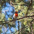 Red-capped Robin, Milbrulong State Forest
 -
 Australian Bindweed, Milbrulong State Forest


See also[edit]
References[edit]
- ^ a b c d Burrows, Geoff E. (1999). "A survey of 25 remnant vegetation sites in the South Western Slopes, New South Wales". Cunninghamia. 6 (2): 283–314.
- ^ a b "NSW State Forests" (PDF). Forestry Corporation. 17 March 2014. Retrieved 22 March 2023.
- ^ a b Stelling, Fleur, ed. (March 1998). South West Slopes Revegetation Guide (PDF). Murrumbidgee Catchment Management Committee. Retrieved 22 March 2023.
- ^ "Forests NSW forest management zones - Riverina Region" (PDF). Forestry Corporation of NSW. January 2008. Retrieved 22 March 2023.
- ^ "Milbrulong". Geographical Names Board of New South Wales. Retrieved 22 March 2023.
- ^ "Rosella". Wiradjuri Condobolin Corporation Language Program. Wiradjuri Condobolin Corporation. Retrieved 22 March 2023.
- ^ "Lockhart Shire Council – 2014-15 State of the Environment Report" (PDF). Lockhart Shire. Retrieved 23 March 2023.
- ^ a b c "Regional Forest Assessment: South-western cypress state forests" (PDF). Natural Resources Commission. Retrieved 22 March 2023.