
Mhaswad
Mhasvad | |
|---|---|
Town | |
 Mhasvad Location in Maharashtra, India | |
| Coordinates: 17°38′06″N 74°47′13″E / 17.635°N 74.787°E | |
| Country | |
| State | Maharashtra |
| District | Satara |
| Talukas | Maan/Dahivadi(Maharashtra) |
| Government | |
| • Body | Municipal Council[1] |
| Population (2011)[2] | |
| • Total | 39,495 |
| Languages | |
| • Official | Marathi |
| • Spoken languages | Marathi |
| Time zone | UTC+5:30 (IST) |
| PIN | 415509/415510 |
| Telephone code | 2373 |
| Vehicle registration | MH-11/satara,phalthan,dahivadi,vaduj |
| Sex ratio | 1.02 ♂/♀ |
| Literacy | 61.37% |
| Distance from Dahiwadi | 25 kilometres (16 mi) (by road) |
Mhaswad or Mhasvad is a city in the Maan/Dahivadi taluka in the Satara district in the Indian state of Maharashtra. The NH-548C Satara-Baitul National Highway passes through the city.[3]
Demographics[edit]
As of 2011[update] India census,[2] Mhaswad had a population of 24,120. Males constitute 12,185 of the population and females 11,935. Mhaswad has an average literacy rate of 74.11%, lower than the state average of 82.34: male literacy is 80.94%, and female literacy is 67.23%. In Mhaswad, 14% of the population is under 6 years of age...
Shree Siddhanatha Rath Yatra[edit]
The famous temple of Lord Siddhanatha is located in Mhaswad. Shree Siddhanatha Rath Yatra is the major annual fair in Mhaswad.[4]
-
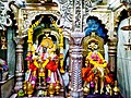 Shree Siddhanatha and Mata Jogeshwari Temple, Mhaswad
 -
 Punyashlok Rajmata Ahilyadevi Holkar Udyan, Mhaswad


References[edit]
- ^ "Municipal Council, Mhaswad". NIC, Govt. of India. Retrieved 19 March 2023.
- ^ a b "Census of India 2001: Data from the 2001 Census, including cities, villages and towns (Provisional)". Census Commission of India. Archived from the original on 16 June 2004. Retrieved 1 November 2008.
- ^ "NH 548C" (PDF). Ministry of Road Transport & Highways, Govt. of India. Retrieved 19 March 2023.
- ^ Shree Siddhanatha Fair, Mhaswad. "Fairs and Festivals of India- Volume-4". Gyan Publishing House. Retrieved 19 March 2023.
Satara district topics | ||
|---|---|---|
| History | .svg) | |
| Battles | ||
| Rivers | ||
| Dams | ||
| Lakes | ||
| Ghats | ||
| Caves | ||
| Cities and towns | ||
| Villages | ||
| Places to see | ||
| Monuments | ||
| Transport | ||
| Education | ||
| Lok Sabha constituencies | ||
| Vidhan Sabha constituencies | ||
| Culture | ||