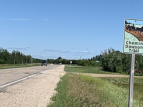
Manitoba Provincial Road 207
| Dawson Road (section) Deacon's Road (section) | ||||
 | ||||
| Route information | ||||
| Maintained by Manitoba Infrastructure | ||||
| Length | 56.7 km (35.2 mi) | |||
| Existed | 1966–present | |||
| Major junctions | ||||
| North end | ||||
| East end | ||||
| Location | ||||
| Country | Canada | |||
| Province | Manitoba | |||
| Rural municipalities | ||||
| Towns | Ste. Anne | |||
| Highway system | ||||
| ||||
Provincial Road 207 (PR 207) is a 56.7-kilometre-long (35.2 mi) provincial road in the Eastman Region of Manitoba, Canada. Much of PR 207 follows the historic Old Dawson Trail.
PR 207 actually switches cardinal directions from north-south to east-west at it's intersection with PTH 1 (Trans-Canada Highway) in Deacons Corner.
Route description[edit]
PR 207 begins at PR 213 (Garven Road), northeast of Winnipeg and heads south, intersecting PTH 15 and then the Trans-Canada Highway (PTH 1) at a junction known as Deacon's Corner. Five kilometres south of the Trans-Canada Highway, the road turns east and follows the old Dawson Road route to the communities of Lorette, Dufresne, and Ste. Anne. Approximately seven kilometres west of Richer, PR 207 turns north and ends at the Trans-Canada Highway.[1]
PR 207 is a paved, two-lane road, except between Dufresne and Ste. Anne, where it is a gravel road. The road has a speed limit of 90 km/h.[2]
The Dawson Road segment of PR 207 between Lorette and Ste. Anne was the original course for PTH 12. A more direct route for PTH 12 was later built to the north; this route is now PTH 1.
Major intersections[edit]
| Division | Location | km | mi | Destinations | Notes |
|---|---|---|---|---|---|
| Springfield | Pine Ridge | 0.0 | 0.0 | Northern terminus; PR 207 begins along Deacon Road; road continues north as Deacon Road | |
| | 8.7 | 5.4 | Bridge over Cooks Creek Diversion | ||
| | 9.8 | 6.1 | |||
| Deacons Corner | 17.1 | 10.6 | PR 207 switches cardinal directions from north-south to east-west | ||
| Taché | | 22.5 | 14.0 | Dawson Road – Prairie Grove | PR 207 begins following Dawson Road |
| Lorette | 28.3 | 17.6 | |||
| | 32.4 | 20.1 | |||
| Dufrense | 39.0 | 24.2 | Western end of unpaved section | ||
| Ste. Anne | | 46.6– 47.2 | 29.0– 29.3 | Interchange; eastern end of unpaved section | |
| City of Ste. Anne | 47.9 | 29.8 | Western end of PR 210 concurrency (overlap) | ||
| 49.8 | 30.9 | Eastern end of PR 210 concurrency | |||
| Ste. Anne | La Coulée | 55.9 | 34.7 | Dawson Road – Richer | PR 207 begins following Municipal Road 40E |
| 56.7 | 35.2 | Eastern terminus; road continues as Municipal Road 40E | |||
1.000 mi = 1.609 km; 1.000 km = 0.621 mi
| |||||
See also[edit]
External links[edit]
References[edit]
- ^ Google (May 15, 2024). "Map of Manitoba Provincial Road 207" (Map). Google Maps. Google. Retrieved May 15, 2024.
- ^ Government of Manitoba. "Official Highway Map of Manitoba section 3" (PDF). Retrieved May 14, 2024.

