
Losdorp
Losdorp | |
|---|---|
 Church in Losdorp | |
 Losdorp Location in the province of Groningen in the Netherlands  Losdorp Losdorp (Netherlands) | |
| Coordinates: 53°23′N 6°50′E / 53.383°N 6.833°E | |
| Country | Netherlands |
| Province | Groningen |
| Municipality | Eemsdelta |
| Area | |
| • Total | 0.26 km2 (0.10 sq mi) |
| Elevation | 0.4 m (1.3 ft) |
| Population (2021)[1] | |
| • Total | 145 |
| • Density | 560/km2 (1,400/sq mi) |
| Postal code | 9907[1] |
| Dialing code | 0596 |
Losdorp (Dutch pronunciation: [ˈlɔzdɔr(ə)p]) is a village in the Dutch province of Groningen. It is a part of the municipality of Eemsdelta, and lies about 25 km northeast of Groningen.
History[edit]
The village was first mentioned in 1429 as "toe Lesdorp", and could mean "little village".[3] Losdorp is a terp (artificial living hill) with a radial structure which has been known to exist since 1053. The terp has been partially excavated.[4]
The church probably dates from the 13th century, but has been extensively modified between 1775 and 1776. The tower dated from 1662, but has also been modified in 1775 and received its current spire in 1848.[4]
Losdorp was home to 94 people in 1840.[5] The terp was restored in 2013.[5]
Gallery[edit]
-
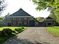 Farm in Losdorp
 -
 House in Losdorp
 -
 View from the church tower


.jpg)
References[edit]
- ^ a b c "Kerncijfers wijken en buurten 2021". Central Bureau of Statistics. Retrieved 7 April 2022.
- ^ "Postcodetool for 9907AA". Actueel Hoogtebestand Nederland (in Dutch). Het Waterschapshuis. Retrieved 7 April 2022.
- ^ "Losdorp - (geografische naam)". Etymologiebank (in Dutch). Retrieved 7 April 2022.
- ^ a b Ronald Stenvert & Redmer Alma (1998). "Losdorp" (in Dutch). Zwolle: Waanders. ISBN 90 400 9258 3. Retrieved 7 April 2022.
- ^ a b "Losdorp". Plaatsengids (in Dutch). Retrieved 7 April 2022.
External links[edit]
 Media related to Losdorp at Wikimedia Commons
This Groningen location article is a stub. You can help Wikipedia by expanding it. |