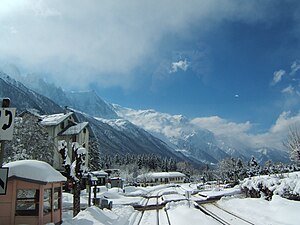
Les Tines station
Les Tines | |||||||||||
|---|---|---|---|---|---|---|---|---|---|---|---|
 The station in 2006 | |||||||||||
| General information | |||||||||||
| Location | Chamonix-Mont-Blanc France | ||||||||||
| Coordinates | 45°57′2.048″N 6°53′56.976″E / 45.95056889°N 6.89916000°E | ||||||||||
| Elevation | 1,082 m (3,550 ft) | ||||||||||
| Owned by | SNCF | ||||||||||
| Line(s) | Saint-Gervais–Vallorcine line | ||||||||||
| Distance | 23.0 km (14.3 mi) from Saint-Gervais-les-Bains-Le Fayet[1] | ||||||||||
| Train operators | TER Auvergne-Rhône-Alpes | ||||||||||
| Connections | Chamonix Bus bus lines[2] | ||||||||||
| Passengers | |||||||||||
| 2019 | 2,759[3] (SNCF) | ||||||||||
| Services | |||||||||||
| |||||||||||
| Location | |||||||||||
 | |||||||||||
Les Tines station (French: Gare des Tines) is a railway station in the commune of Chamonix-Mont-Blanc, in the French department of Haute-Savoie. It is located on the 1,000 mm (3 ft 3+3⁄8 in) gauge Saint-Gervais–Vallorcine line of SNCF.[1]
Services[edit]
As of the December 2020 timetable change,[update] the following services stop at Les Tines:[4]
- TER Auvergne-Rhône-Alpes: hourly service between Saint-Gervais-les-Bains-Le Fayet and Vallorcine.
References[edit]
- ^ a b Eisenbahnatlas Schweiz. Cologne: Schweers + Wall. 2012. p. 54. ISBN 978-3-89494-130-7.
- ^ "Plans du réseau" (in French). Chamonix Bus. Retrieved 26 January 2021.
- ^ "Fréquentation en gares" (in French). SNCF. 20 November 2020. Retrieved 26 January 2021.
- ^ "Horaires" (PDF) (in French). SNCF. 13 December 2020. Retrieved 26 January 2021.
External links[edit]
 Media related to Gare des Tines at Wikimedia Commons
- Les Tines station – TER Auvergne-Rhône-Alpes
