L'Atzúbia
L'Atzúbia | |
|---|---|
 | |
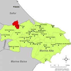
 Location in the comarca Marina Alta, within the Province of Alicante | |
| Coordinates: 38°45′44″N 0°11′17″E / 38.76222°N 0.18806°E | |
| Country | |
| Province | Alicante |
| Comarca | Marina Alta |
| Government | |
| • Mayor | Josep Vicent Vidal Torralba |
| Area | |
| • Total | 14.73 km2 (5.69 sq mi) |
| Elevation | 102 m (335 ft) |
| Population (2018)[1] | |
| • Total | 661 |
| • Density | 45/km2 (120/sq mi) |
| • Language | Valencian |
| Demonym(s) | atzubià, atzubiana |
| Postcode | 03786 |
| Distance to Alicante: | 104 km (65 mi) |
| Website | www.atzubia-forna.org |
L'Atzúbia (Valencian: [ladˈdzubia])[2] is a municipality in the comarca of Marina Alta in the north of the province of Alicante, in the Valencian Community, Spain.
It is enclaved in the Pego Valley. The neighbouring municipalities are: Vilallonga and Oliva to the north, Oliva and Pego to the east, La Vall de Gallinera and Vilallonga to the west; and La Vall de Gallinera and Pego to the south.
References[edit]
- ^ Municipal Register of Spain 2018. National Statistics Institute.
- ^ Spanish exonym Adsubia (Spanish: [aðˈsuβja])
External links[edit]
- Diputació d'Alacant - Unidad de Documentación (in Spanish)
Wikimedia Commons has media related to Adsubia.


