
Hochspeyer
Hochspeyer | |
|---|---|
 Coat of arms | |
Location of Hochspeyer within Kaiserslautern district 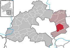 | |
 Hochspeyer  Hochspeyer | |
| Coordinates: 49°26′34″N 7°53′48″E / 49.44278°N 7.89667°E | |
| Country | Germany |
| State | Rhineland-Palatinate |
| District | Kaiserslautern |
| Municipal assoc. | Enkenbach-Alsenborn |
| Government | |
| • Mayor (2019–24) | Dominic Jonas[1] (CDU) |
| Area | |
| • Total | 22.72 km2 (8.77 sq mi) |
| Elevation | 267 m (876 ft) |
| Population (2022-12-31)[2] | |
| • Total | 4,738 |
| • Density | 210/km2 (540/sq mi) |
| Time zone | UTC+01:00 (CET) |
| • Summer (DST) | UTC+02:00 (CEST) |
| Postal codes | 67691 |
| Dialling codes | 06305 |
| Vehicle registration | KL |
| Website | www.hochspeyer-pfalz.de |
Hochspeyer is a municipality in the district of Kaiserslautern, in Rhineland-Palatinate, Germany. It is situated in the Palatinate forest (Pfälzer Wald), approx. 10 km east of Kaiserslautern.
Hochspeyer was the seat of the former Verbandsgemeinde Hochspeyer ("collective municipality").
History[edit]
Hochspeyer's history is closely related to the Cistercian Abbey of Otterberg, to which the Münchhof belonged since 1195.
In 1801 the region Palatinate became part of the French Département Mont-Tonnerre, and in 1815 it became part of the Bavarian Kingdom.
After World War II Palatinate (and with it Hochspeyer) was incorporated in the federal state of Rhineland-Palatinate.
Education[edit]
Hochspeyer has the Münchhofschule (a primary and secondary school) as well as three Kindergartens.
Economy[edit]
Trade, minor industry and farming shape the small local economy in Hochspeyer. Tourism is about to develop since the Palatinate forest has become part of the biosphere reserve Pfälzer Wald-Vosges du Nord in 1998 and projects like the Mountainbikepark Pfälzerwald, a route network for mountainbiking, have been initiated.
-
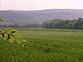 Farmland and forests form Hochspeyer's environment
 -
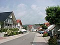 New development areas lead to a rise of population
 -
 Good traffic infrastructure and the Palatine Forest attract tourists


Transport[edit]
Hochspeyer is near the A6 and A63 motorways. It is also served by the B37 and B49 roads.
For rail, Hochspeyer is served by RheinNeckar S-Bahn trains on the Saarbrücken–Mannheim line between Kaiserslautern/Homburg and Mannheim/Heidelberg half-hourly.
Climate[edit]
Climate in this area has mild differences between highs and lows, and there is adequate rainfall year-round. The Köppen Climate Classification subtype for this climate is "Cfb" (Marine West Coast Climate/Oceanic climate).[3]
| Climate data for Hochspeyer | |||||||||||||
|---|---|---|---|---|---|---|---|---|---|---|---|---|---|
| Month | Jan | Feb | Mar | Apr | May | Jun | Jul | Aug | Sep | Oct | Nov | Dec | Year |
| Mean daily maximum °C (°F) | 1 (33) |
3 (37) |
8 (46) |
12 (53) |
16 (60) |
20 (68) |
21 (69) |
20 (68) |
18 (64) |
13 (55) |
6 (42) |
3 (37) |
11 (51) |
| Mean daily minimum °C (°F) | −3 (26) |
−2 (28) |
0 (32) |
3 (37) |
6 (42) |
10 (50) |
12 (53) |
11 (51) |
9 (48) |
5 (41) |
1 (33) |
0 (32) |
4 (39) |
| Average precipitation mm (inches) | 58 (2.3) |
51 (2) |
46 (1.8) |
46 (1.8) |
51 (2) |
66 (2.6) |
61 (2.4) |
76 (3) |
64 (2.5) |
48 (1.9) |
51 (2) |
64 (2.5) |
680 (26.8) |
| Source: Weatherbase [4] | |||||||||||||
Notable people[edit]
- Johannes Böhm (1890–1957), politician (SPD)
- Wilhelm Moschel (1896–1954), chemist
- Karl Ritter (1916–1994), politician (SPD)
- Hugo Ohliger (1920–1999), politician (CSU)
- Peter Schwarz (born 1953), football player
References[edit]
- ^ Direktwahlen 2019, Landkreis Kaiserslautern, Landeswahlleiter Rheinland-Pfalz, accessed 9 August 2021.
- ^ "Bevölkerungsstand 2022, Kreise, Gemeinden, Verbandsgemeinden" (PDF) (in German). Statistisches Landesamt Rheinland-Pfalz. 2023.
- ^ Climate Summary for Hochspeyer from Weatherbase.com
- ^ "Weatherbase.com". Weatherbase. 2013. Retrieved on July 6, 2013.
External links[edit]
- Hochspeyer Web Site Tourism and Community Town site

| International | |
|---|---|
| National | |