
File:Track elevation 2-.pdf

Size of this JPG preview of this PDF file: 800 × 390 pixels. Other resolutions: 320 × 156 pixels | 640 × 312 pixels | 1,024 × 499 pixels | 1,650 × 804 pixels.
Original file (1,650 × 804 pixels, file size: 438 KB, MIME type: application/pdf)
Summary[edit]
| This image was uploaded in a non-image format. The information it contains could be stored more efficiently in the PNG format, the SVG format, as plain text in an article, or (rarely) in JPEG format. If the information is encyclopedic, please integrate its text and information into an article, or consider copying its contents to Wikisource if it is freely licensed. If the contents are unencyclopedic or a copyright violation, please consider proposing it for deletion using {{subst:Proposed deletion|concern=reason for proposed deletion}}. For more information, see Wikipedia:Preparing images for upload. |
| Description |
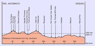
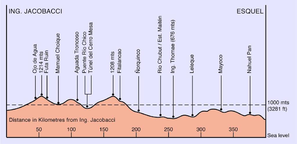
Es: Gráfica de alturas En: Route track elevation chart |
|---|---|
| Source |
Es: Gráfica en base a datos de Domínio Público de Internet. En: self-made chart from public domain data information obtained from several internet sources. |
| Date |
28 February 2008 |
| Author | |
| Permission (Reusing this file) |
See below.
|
Licensing[edit]
I, the copyright holder of this work, hereby publish it under the following licenses:
| This work is licensed under the Creative Commons Attribution-ShareAlike 3.0 License. |
 | Permission is granted to copy, distribute and/or modify this document under the terms of the GNU Free Documentation License, Version 1.2 or any later version published by the Free Software Foundation; with no Invariant Sections, no Front-Cover Texts, and no Back-Cover Texts. |
You may select the license of your choice.
 | This file is a candidate to be copied to Wikimedia Commons.
Any user may perform this transfer; refer to Wikipedia:Moving files to Commons for details. If this file has problems with attribution, copyright, or is otherwise ineligible for Commons, then remove this tag and DO NOT transfer it; repeat violators may be blocked from editing. Other Instructions
| ||
| |||
| This media file is either in the public domain or published under a free license, and contains no inbound file links. If this media file is useful, then it should be transferred to the Wikimedia Commons. If this media is not useful, then please propose it for deletion or list it at files for discussion. |
File history
Click on a date/time to view the file as it appeared at that time.
| Date/Time | Thumbnail | Dimensions | User | Comment | |
|---|---|---|---|---|---|
| current | 20:38, 4 March 2008 |  | 1,650 × 804 (438 KB) | Moebiusuibeom-en (talk | contribs) | {{Information |Description= '''Es: '''Gráfica de alturas '''En: '''Route track elevation chart |Source='''Es:''' Gráfica en base a datos de Domínio Público de Internet. '''En: ''' self-made chart from public domain data information o |
You cannot overwrite this file.
File usage
No pages on the English Wikipedia use this file (pages on other projects are not listed).