
File:Plat of the Shoquel Rancho.pdf

Size of this JPG preview of this PDF file: 800 × 579 pixels. Other resolutions: 320 × 231 pixels | 640 × 463 pixels | 1,024 × 741 pixels | 1,280 × 926 pixels | 2,560 × 1,852 pixels | 3,029 × 2,191 pixels.
Original file (3,029 × 2,191 pixels, file size: 135 KB, MIME type: application/pdf)
| This is a file from the Wikimedia Commons. Information from its description page there is shown below. Commons is a freely licensed media file repository. You can help. |
Summary
| Description |
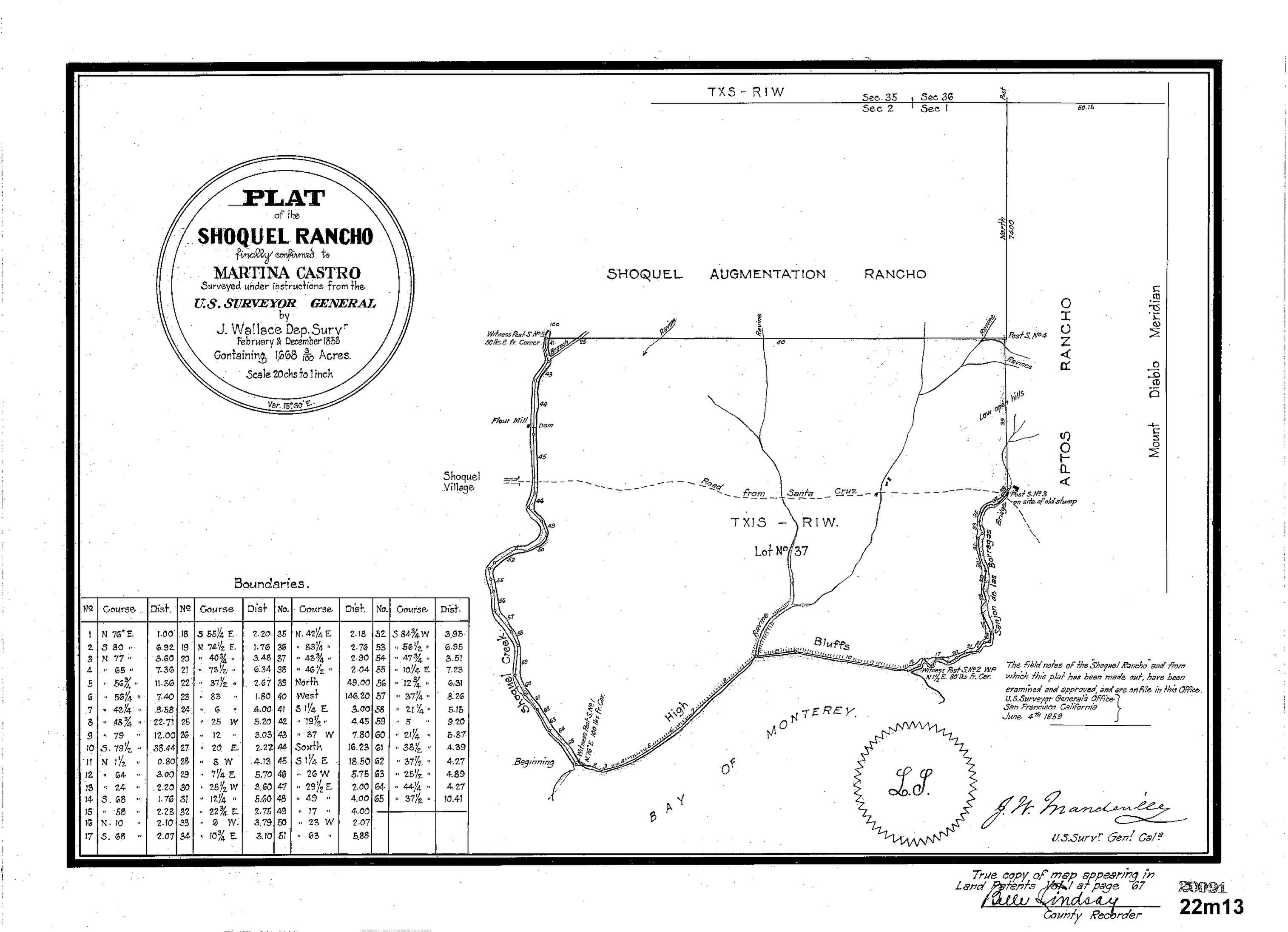
English: Plat of the Shoquel Rancho finally confirmed to Martina Castro. Surveyed under instructions from the U.S. Surveyor General by J. Wallace Dep. Survr. February & December 1858 containing 1,668.03 Acres. Scale 20 chs to 1 inch. |
| Date | |
| Source |
Original publication: U.S. Surveyor General's Office, San Francisco California, June 4th 1859 |
| Author |
John Wallace, Deputy Surveyor |
This work is in the public domain in the United States because it was published (or registered with the U.S. Copyright Office) before January 1, 1929.
Public domain works must be out of copyright in both the United States and in the source country of the work in order to be hosted on the Commons. If the work is not a U.S. work, the file must have an additional copyright tag indicating the copyright status in the source country.
Note: This tag should not be used for sound recordings. |
File history
Click on a date/time to view the file as it appeared at that time.
| Date/Time | Thumbnail | Dimensions | User | Comment | |
|---|---|---|---|---|---|
| current | 05:07, 29 May 2020 |  | 3,029 × 2,191 (135 KB) | Keavon | {{subst:Upload marker added by en.wp UW}} {{Information |Description = {{en|Plat of the Shoquel Rancho finally confirmed to Martina Castro. Surveyed under instructions from the U.S. Surveyor General by J. Wallace Dep. Survr. February & December 1858 containing 1,668.03 Acres. Scale 20 chs to 1 inch.}} |Source = '''Original publication''': U.S. Surveyor General's Office, San Francisco California, June 4th 1859<br/> '''Immediate source''': https://gis.santacruzcounty.us/DPWScans/recordmaps/022M... |
File usage
The following pages on the English Wikipedia use this file (pages on other projects are not listed):