
File:Duane Garrett, Photographer 1976 EAST ELEVATION - Masonic Temple, Idaho Lodge Number 1, Wall Street, Idaho City, Boise County, ID HABS ID,8-IDCI,1-4.tif

Size of this JPG preview of this TIF file: 755 × 600 pixels. Other resolutions: 302 × 240 pixels | 604 × 480 pixels | 967 × 768 pixels | 1,280 × 1,017 pixels | 2,560 × 2,034 pixels | 4,578 × 3,638 pixels.
Original file (4,578 × 3,638 pixels, file size: 15.89 MB, MIME type: image/tiff)
| This is a file from the Wikimedia Commons. Information from its description page there is shown below. Commons is a freely licensed media file repository. You can help. |
Summary
| Duane Garrett, Photographer 1976 EAST ELEVATION - Masonic Temple, Idaho Lodge Number 1, Wall Street, Idaho City, Boise County, ID | ||||
|---|---|---|---|---|
| Photographer |
Related names:
|
|||
| Title |
Duane Garrett, Photographer 1976 EAST ELEVATION - Masonic Temple, Idaho Lodge Number 1, Wall Street, Idaho City, Boise County, ID |
|||
| Depicted place | Idaho; Boise County; Idaho City | |||
| Date | Documentation compiled after 1933 | |||
| Dimensions | 4 x 5 in. | |||
| Current location |
Library of Congress Prints and Photographs Division Washington, D.C. 20540 USA http://hdl.loc.gov/loc.pnp/pp.print |
|||
| Accession number |
HABS ID,8-IDCI,1-4 |
|||
| Credit line |
|
|||
| Notes |
|
|||
| Source | https://www.loc.gov/pictures/item/id0026.photos.060272p | |||
| Permission (Reusing this file) |
|
|||

| Object location | | View this and other nearby images on: OpenStreetMap |
|---|
File history
Click on a date/time to view the file as it appeared at that time.
| Date/Time | Thumbnail | Dimensions | User | Comment | |
|---|---|---|---|---|---|
| current | 18:17, 14 July 2014 | 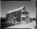 | 4,578 × 3,638 (15.89 MB) | Fæ | GWToolset: Creating mediafile for Fæ. HABS 11 July 2014 (1001:1200) |
File usage
The following pages on the English Wikipedia use this file (pages on other projects are not listed):