
File:Context view, showing the Relift Station, Ditch Rider's House, and Mohawk Mountains in the background. View to south - Wellton-Mohawk Irrigation System, Relift Station, Texas Hill Canal HAER AZ-68-D-1.tif

Size of this JPG preview of this TIF file: 756 × 599 pixels. Other resolutions: 303 × 240 pixels | 605 × 480 pixels | 969 × 768 pixels | 1,280 × 1,015 pixels | 2,560 × 2,030 pixels | 5,362 × 4,252 pixels.
Original file (5,362 × 4,252 pixels, file size: 21.75 MB, MIME type: image/tiff)
| This is a file from the Wikimedia Commons. Information from its description page there is shown below. Commons is a freely licensed media file repository. You can help. |
Summary
| Photographer |
De Vries, David G. |
|||
| Title |
Context view, showing the Relift Station, Ditch Rider's House, and Mohawk Mountains in the background. View to south - Wellton-Mohawk Irrigation System, Relift Station, Texas Hill Canal 2.5, Northern Terminus of Avenue 51 East, approximately .5 mile south of Union Pacific Railroad, Wellton, Yuma County, AZ |
|||
| Depicted place | Arizona; Yuma County; Wellton | |||
| Date | 2005 | |||
| Dimensions | 4 x 5 in. | |||
| Current location |
Library of Congress Prints and Photographs Division Washington, D.C. 20540 USA http://hdl.loc.gov/loc.pnp/pp.print |
|||
| Accession number |
HAER AZ-68-D-1 |
|||
| Credit line |
|
|||
| Notes |
|
|||
| Source | https://www.loc.gov/pictures/item/az0535.photos.363745p | |||
| Permission (Reusing this file) |
|

| Object location | | View this and other nearby images on: OpenStreetMap |
|---|
File history
Click on a date/time to view the file as it appeared at that time.
| Date/Time | Thumbnail | Dimensions | User | Comment | |
|---|---|---|---|---|---|
| current | 23:54, 1 July 2014 | 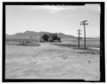 | 5,362 × 4,252 (21.75 MB) | Fæ | GWToolset: Creating mediafile for Fæ. HABS 1 July 2014 (201:300) |
File usage
The following pages on the English Wikipedia use this file (pages on other projects are not listed):
Global file usage
The following other wikis use this file:
- Usage on fr.wikipedia.org