
File:Alphonse michoud map.tif

Size of this JPG preview of this TIF file: 613 × 599 pixels. Other resolutions: 246 × 240 pixels | 491 × 480 pixels | 786 × 768 pixels | 1,048 × 1,024 pixels | 2,095 × 2,048 pixels | 9,600 × 9,384 pixels.
Original file (9,600 × 9,384 pixels, file size: 515.55 MB, MIME type: image/tiff)
| This is a file from the Wikimedia Commons. Information from its description page there is shown below. Commons is a freely licensed media file repository. You can help. |
Summary
| Description |
English: 1883 map from court case REE DE MONTLUZIN CO. v. NEW ORLEANS NER CO describing land from Little Woods to Alphonse Michoud plantation |
| Date | |
| Source | scanned antique map |
| Author | Geo. H. Grandjean (1846-1900) civil engineer |
| Other versions |
|
}}
Licensing
This work is in the public domain in the United States because it was published (or registered with the U.S. Copyright Office) before January 1, 1929.
|
|
This work is in the public domain in its country of origin and other countries and areas where the copyright term is the author's life plus 100 years or fewer.
| |
| This file has been identified as being free of known restrictions under copyright law, including all related and neighboring rights. | |
File history
Click on a date/time to view the file as it appeared at that time.
| Date/Time | Thumbnail | Dimensions | User | Comment | |
|---|---|---|---|---|---|
| current | 10:15, 3 August 2022 | 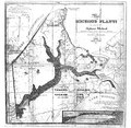 | 9,600 × 9,384 (515.55 MB) | Waterwalker69 | Uploaded a work by T. N. Grandjean civil engineer from scanned antique map with UploadWizard |
File usage
The following pages on the English Wikipedia use this file (pages on other projects are not listed):