Dalston, Cumbria
This article needs additional citations for verification. (September 2014) |
| Dalston | |
|---|---|
| Village and parish | |
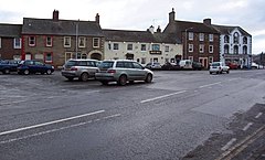
 The Square at Dalston | |
Location in the former City of Carlisle district Location within Cumbria | |
| Population | 2,590 (2011)[1] |
| OS grid reference | NY395555 |
| • London | 261 mi (420 km) SSE |
| Civil parish |
|
| Unitary authority | |
| Ceremonial county | |
| Region | |
| Country | England |
| Sovereign state | United Kingdom |
| Post town | CARLISLE |
| Postcode district | CA5 |
| Dialling code | 01228 |
| Police | Cumbria |
| Fire | Cumbria |
| Ambulance | North West |
| UK Parliament | |
Dalston is a large village and civil parish within Cumberland unitary authority area, Cumbria, and historically part of Cumberland. It is situated on the B5299 road 4 miles (6 km) south-south-west of Carlisle city centre, and approximately 5 miles (8 km) from Junction 42 of the M6 motorway.
The village is on the River Caldew, just to the north of where the Roe Beck joins the river. It is served by the Dalston railway station on the Cumbrian Coast Line between Carlisle, Workington + Barrow-in-Furness.
Historic buildings[edit]

Rose Castle, home of the Bishop of Carlisle for many centuries until 2009, is within the parish of Dalston, 1.5 miles (2 km) from the heart of the village. The architects Anthony Salvin and Thomas Rickman were responsible for the alterations which took place in the 19th century.
Dalston Hall is a grade II* listed fortified house which is now a country house hotel.[2]
Dalston has two churches; St Michael's + All Angels Church.
Governance[edit]
There is a county electoral division of Dalston, stretching north towards Carlisle, with a total population at the 2011 United Kingdom census of 6,051.[3]
Education[edit]
There are two schools in Dalston, St. Michaels Primary School and Caldew Secondary School.
Economy[edit]
There is a Nestlé factory producing powdered milk, a BP fuel depot and the Barras Lane trading estate.
Notable people[edit]
- Sir James Graham, 2nd Baronet (1792–1861) was educated at Dalston.[4]
- Georgiana Harcourt (1807–1886), translator, was born at Dalston while her father Edward Venables-Vernon-Harcourt was Bishop of Carlisle.[5]
- William Paley (1743–1805), was Vicar of Dalston in the 1780s.[6]
- Edward Rainbowe (1608–1684) lived here while Bishop of Carlisle.
- George Robinson (1737–1801), London publisher, was born here.[7]
- Sarah Story, DJ[8]
- Musgrave Watson (1804–1847), sculptor, was born here.
See also[edit]
References[edit]
- ^ "Parish population 2011". Retrieved 24 June 2015.
- ^ "Dalston Hall Ny 376515, Dalston". British Listed Buildings. Retrieved 10 September 2013.
- ^ "Ward population 2011". Retrieved 24 June 2011.
- ^ Jonathan Parry, "Graham, Sir James Robert George, second baronet (1792–1861)", in Oxford Dictionary of National Biography (OUP, 2004) online at doi:10.1093/ref:odnb/11204 (subscription required)
- ^ Baptism on 27 July 1807 at the Parish Church, Dalston: “Georgiana Charlotte Frances Harcourt daughter of Edward and Ann Harcourt”
- ^ James E. Crimmins, "William Paley (1743–1805)" in Oxford Dictionary of National Biography (OUP, 2004)
- ^ Henry Richard Tedder, ”Robinson, George“, in Dictionary of National Biography, 1885-1900, Volume 49
- ^ "Driven to DJ". Carlisle Living. Archived from the original on 12 August 2020. Retrieved 17 January 2022.
External links[edit]
- Cumbria County History Trust: Dalston (nb: provisional research only – see Talk page)
- Dalston Community Website


