
Creevelea Abbey
Mainistir na Craoibhe Léithe | |
 | |
 Location within Ireland | |
| Monastery information | |
|---|---|
| Other names | Creevlea Abbey, Creebelea Abbey, Craobhliath, Crowlekale, Crueleach, Carrag Patrice, Petra Patricii, Druim-da-ethair, Baile-ui-ruairc, Ballegruaircy, Cuivelleagh, Killanummery.[1] |
| Order | Third Order of Saint Francis (Order of Penance) |
| Established | 1508 |
| Disestablished | 1837 |
| Diocese | Kilmore |
| People | |
| Founder(s) | Eóghan Ó Ruairc |
| Architecture | |
| Status | Inactive |
| Site | |
| Location | Creevelea, Dromahair, County Leitrim |
| Coordinates | 54°13′53″N 8°18′35″W / 54.231291°N 8.309791°W |
| Visible remains | church walls, one or two unstable stairs, the perimeter structure. |
| Public access | yes, as a burial site |
| Official name | Creevelea Abbey |
| Reference no. | 69[2] |
Creevelea Abbey is a medieval Franciscan friary and National Monument located in Dromahair, County Leitrim, Ireland.[3] Creeveley Abbey is now in use for as a grave yard.
Location[edit]
Creevelea Abbey is located west of Dromahair, on the west bank of the Bonet River.[4][5]
History[edit]
Creevelea Friary was founded in 1508 by Eóghan O'Rourke, Lord of West Bréifne, and his wife Margaret O'Brian, daughter of a King of Thomond. The friary was accidentally burned in 1536 and was rebuilt by Brian Ballach O'Rourke. In 1590 Richard Bingham stabled his horses at Creevelea during his pursuit of Brian O'Rourke, who had sheltered survivors of the Spanish Armada. Dissolved c. 1598.[citation needed]
Sir Tadhg O'Rourke (d. 1605), last King of West Bréifne and Thaddeus Francis O'Rourke (d. 1735), Bishop of Killala are buried here. Another house was built for the friars in 1618 and Creevelea was reoccupied by friars in 1642. The Franciscans were driven out by the Cromwellian Army in the 1650s.[6][7] After the Restoration, the abbey remained in use until 1837.[citation needed]
Buildings[edit]
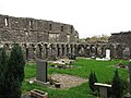
The remains consist of the church (nave, chancel, transept and choir), chapter house, cloister and domestic buildings. The bell-tower was converted to living quarters in the 17th century. At one point in its history the church was covered with a thatched roof. Carved in the cloister is an image of Saint Francis of Assisi preaching to birds.[8][9]
Archaeological Preservation[edit]
The site is preserved as a national monument.[10]
-
 Tower
Tower -
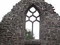 Window with tracery
 -
 Cloister
 -
 Creevela Abbey 1791
 -
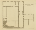 Floorplan 1791


_-_geograph.org.uk_-_1637297.jpg)


References and Notes[edit]
Notes[edit]
Citations[edit]
- ^ Sunflower Guides 2004, pp. 10.
- ^ "National Monuments of County Leitrim in State Care" (PDF). heritageireland.ie. National Monument Service. p. 1. Retrieved 2 July 2020.
- ^ TripAdvisor.
- ^ Brewer 2008, pp. 365.
- ^ Day 2006, pp. 334.
- ^ megalithicireland.
- ^ Higgins.
- ^ The Sligo Town Website.
- ^ Manorhamilton.ie 2012.
- ^ National Monuments Service 2009, pp. 1.
Primary sources[edit]
- Sunflower Guides (1 March 2004). Ireland. Hunter Publishing, Inc. ISBN 9781856912433 – via Google Books.
- TripAdvisor. "Creevelea Friary (Leitrim, Ireland): Top Tips Before You Go - TripAdvisor". TripAdvisor.
- Brewer, Stephen (29 September 2008). Attraction on Lough Gill. Vol. The Unofficial Guide to Ireland. John Wiley & Sons. ISBN 9780470285688 – via Google Books.
- Day, Catharina (1 January 2006). The province of Connacht, Around Drumahair. Vol. Ireland. New Holland Publishers. ISBN 9781860113277. Archived from the original on 16 January 2017. Retrieved 30 September 2016 – via Google Books.
- megalithicireland. "Creevelea Abbey". megalithicireland.com.
- Higgins, Gerard. "Creevelea Abbey". sligotours.com.
- "Creevelea Abbey in Dromahair". The Sligo Town Website.
- Manorhamilton.ie (2012). "Creevelea Abbey". manorhamilton.ie. Archived from the original on 2 October 2016. Retrieved 27 June 2012.
Secondary sources[edit]
- National Monuments Service (2009). Leitrim (PDF) (Report). Vol. National Monuments in State Care: Ownership & Guardianship. Environment, Heritage and Local Government.