
Commercial Road Lock
| Commercial Road Lock (No.12) | |
|---|---|
 Commercial Road Lock, 2008 | |
 | |
| 51°30′45″N 0°02′12″W / 51.512362°N 0.036607°W | |
| Waterway | Regent's Canal |
| County | Tower Hamlets Greater London |
| Maintained by | Canal & River Trust |
| Fall | 8 feet (2.4 m) |
| Distance to Limehouse Basin | 0.13 miles (0.21 km) |
| Distance to Paddington Basin | 8.8 miles (14.2 km) |
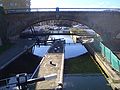
Commercial Road Lock is a lock on the Regent's Canal in the London Borough of Tower Hamlets. It marks the point at which the canal enters Limehouse Basin, and is the penultimate lock before the canal reaches the Thames.
The nearest Docklands Light Railway station is Limehouse.
Gallery[edit]
-
 Commercial Road Lock on the Regent's Canal entering the Limehouse Basin

See also[edit]
References[edit]
This United Kingdom canal-related article is a stub. You can help Wikipedia by expanding it. |