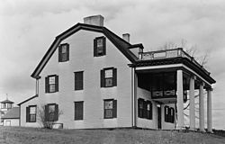
Col. Jonathan Tyng House
Col. Jonathan Tyng House | |
 HABS photo, 1936 | |
| Nearest city | Tyngsborough, Massachusetts |
|---|---|
| Coordinates | 42°39′37″N 71°24′28″W / 42.66028°N 71.40778°W |
| Built | 1675 |
| Architect | Jonathan Tyng |
| NRHP reference No. | 77000188[1] |
| Added to NRHP | August 19, 1977 |
The Col. Jonathan Tyng House was a historic house on Tyng Road in Tyngsborough, Massachusetts. The oldest portion of this gambrel-roofed wood-frame house was built c. 1675 by Colonel Jonathan Tyng, the son of Edward Tyng for whom Tyngsborough is named. The house had a number of pre-Georgian features, including portholes under the eaves, through which muskets could be fired at attackers, and brick lining in the walls. The upper level also had quarters that were used by the Tyngs to house slaves.[2] The property was listed on the National Register of Historic Places in 1977;[1] It was destroyed by fire on August 11, 1977.[1]
See also[edit]
References[edit]
- ^ a b c "National Register Information System". National Register of Historic Places. National Park Service. April 15, 2008.
- ^ "MACRIS inventory record for Col. Jonathan Tyng House". Commonwealth of Massachusetts. Retrieved 2014-07-31.

Wikimedia Commons has media related to Jonathan Tyng House.
Categories:
- Houses completed in 1675
- Houses on the National Register of Historic Places in Middlesex County, Massachusetts
- Tyngsborough, Massachusetts
- Demolished buildings and structures in Massachusetts
- 1675 establishments in the Massachusetts Bay Colony
- Middlesex County, Massachusetts Registered Historic Place stubs


