Cloughduv
Cloghduv
Cloch Dhubh Cloghduff | |
|---|---|
Village | |
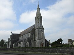
 Saint Joseph's Roman Catholic church, Cloughduv | |
| Coordinates: 51°50′49″N 08°47′16″W / 51.84694°N 8.78778°W | |
| Country | Ireland |
| Province | Munster |
| County | County Cork |
| Population | 360 |
| Time zone | UTC+0 (WET) |
| • Summer (DST) | UTC-1 (IST (WEST)) |
Cloghduv or Cloghduff (/klɒxˈdʌv/ klokh-DUV; Irish: Cloch Dhubh, meaning "black stone")[2] is a village in County Cork, Ireland. It has a population of 360 people.[1] The main industry is agriculture, although it is also a commuter village for Cork City.[3] Cloughduv is part of the Dáil constituency of Cork North-West. The village is 1.4 km from the River Bride.
Amenities[edit]
The village of Cloughduv consists of a pub, a shop, a church and a number of housing estates.[3] The former Cloughduv Creamery closed in 2018 after 126 years in business.[citation needed] Cloughduv is served by St. Joseph's Catholic Church.[4]
Cloughduv GAA is the local Gaelic Athletic Association club.[5]
See also[edit]
References[edit]
- ^ a b "Sapmap Area - Settlements - Cloughduv". Census 2016. Central Statistics Office. April 2016. Retrieved 30 April 2020.
- ^ "An Chloch Dhubh / Cloghduff". logainm.ie. Placenames Database of Ireland. Retrieved 30 April 2020.
- ^ a b "Cloughduv". Macroom Electoral Area Local Area Plan (PDF). Cork Local Area Plans (Report). Cork County Council. 2005. p. 64. Retrieved 17 June 2021.
- ^ "Kilmurry Parish". corkandross.org. Diocese of Cork and Ross. Archived from the original on 17 May 2011.
- ^ "Cloughduv Club Site". cloughduvgaa.ie. Archived from the original on 21 July 2011.
External links[edit]


