Burnand
From Wikipedia, the free encyclopedia
For the surname, see Burnand (surname).
Commune in Bourgogne-Franche-Comté, France
Burnand | |
|---|---|
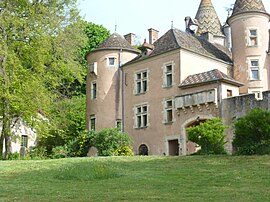
 The chateau in Burnand | |
| Coordinates: 46°35′45″N 4°37′52″E / 46.5958°N 4.6311°E / 46.5958; 4.6311 | |
| Country | France |
| Region | Bourgogne-Franche-Comté |
| Department | Saône-et-Loire |
| Arrondissement | Chalon-sur-Saône |
| Canton | Cluny |
| Intercommunality | Sud Côte Chalonnaise |
| Area 1 | 6.52 km2 (2.52 sq mi) |
| Population (2021)[1] | 122 |
| • Density | 19/km2 (48/sq mi) |
| Time zone | UTC+01:00 (CET) |
| • Summer (DST) | UTC+02:00 (CEST) |
| INSEE/Postal code | 71067 /71460 |
| Elevation | 219–403 m (719–1,322 ft) (avg. 260 m or 850 ft) |
| 1 French Land Register data, which excludes lakes, ponds, glaciers > 1 km2 (0.386 sq mi or 247 acres) and river estuaries. | |
Burnand (French pronunciation: [byʁnɑ̃]) is a commune in the Saône-et-Loire department in the region of Bourgogne-Franche-Comté in eastern France.
See also[edit]
References[edit]
- ^ "Populations légales 2021". The National Institute of Statistics and Economic Studies. 28 December 2023.
Wikimedia Commons has media related to Burnand.
| Authority control databases: National |
|---|
This Saône-et-Loire geographical article is a stub. You can help Wikipedia by expanding it. |
Retrieved from "https://en.wikipedia.org/w/index.php?title=Burnand&oldid=1110523175"
Hidden categories:
- Articles with short description
- Short description is different from Wikidata
- Coordinates on Wikidata
- Pages using infobox settlement with image map1 but not image map
- Pages with French IPA
- Commons category link from Wikidata
- Articles with BNF identifiers
- Articles with BNFdata identifiers
- All stub articles
- Pages using the Kartographer extension


