
Ankeveen
Ankeveen | |
|---|---|
Village | |
 | |
 Ankeveen Location in the Netherlands  Ankeveen Location in the province of North Holland in the Netherlands | |
| Coordinates: 52°15′55″N 5°05′56″E / 52.2653°N 5.0989°E | |
| Country | Netherlands |
| Province | North Holland |
| Municipality | Wijdemeren |
| Area | |
| • Total | 8.61 km2 (3.32 sq mi) |
| Elevation | 0.0 m (0.0 ft) |
| Population (2021)[1] | |
| • Total | 1,530 |
| • Density | 180/km2 (460/sq mi) |
| Time zone | UTC+1 (CET) |
| • Summer (DST) | UTC+2 (CEST) |
| Postal code | 1244[1] |
| Dialing code | 035 |
Ankeveen is a village in the Dutch province of North Holland. It is a part of the municipality of Wijdemeren, and lies about 5 km west of Bussum.
The village was first mentioned in 1344 as Tankenveen, and means "peat excavation of Tanke (person)".[3] Ankeveen is a stretched out peat concession village.[4]
The buitenplaats Berg en Vaart was built near Ankeveen between 1779 and 1782 by an Amsterdam wine merchant. It is surrounded by a large park designed in the 18th century.[4]
West of the village, there is a fen area, the Ankeveense Plassen which is a result of the peat excavation in the area.[5]
Until 1966, Ankeveen was a separate municipality. In 2002, it became part of the municipality of Wijdemeren.[5]
Gallery[edit]
-
 Clergy house
 -
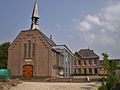 Former church now theatre
 -
 House in Ankeveen
 -
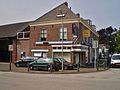 Shop in Ankeveen


References[edit]
- ^ a b c "Kerncijfers wijken en buurten 2021". Central Bureau of Statistics. Retrieved 2 May 2022.
- ^ "Postcodetool for 1244NL". Actueel Hoogtebestand Nederland (in Dutch). Het Waterschapshuis. Retrieved 2 May 2022.
- ^ "Ankeveen - (geografische naam)". Etymologiebank (in Dutch). Retrieved 2 May 2022.
- ^ a b Ronald Stenvert & Saskia van Ginkel-Meester (2006). "Ankeveen" (in Dutch). Zwolle: Waanders. Retrieved 2 May 2022.
- ^ a b "Ankeveen". Plaatsengids (in Dutch). Retrieved 2 May 2022.
| Authority control databases: Geographic |
|---|
This North Holland location article is a stub. You can help Wikipedia by expanding it. |