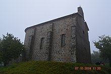
Ajoux
Ajoux | |
|---|---|
 Ajoux Water Troughs | |
| Coordinates: 44°45′27″N 4°29′39″E / 44.7575°N 4.4942°E | |
| Country | France |
| Region | Auvergne-Rhône-Alpes |
| Department | Ardèche |
| Arrondissement | Privas |
| Canton | Privas |
| Intercommunality | CA Privas Centre Ardèche |
| Government | |
| • Mayor (2020–2026) | Adrien Feougier[1] |
| Area 1 | 12.2 km2 (4.7 sq mi) |
| Population (2021)[2] | 80 |
| • Density | 6.6/km2 (17/sq mi) |
| Time zone | UTC+01:00 (CET) |
| • Summer (DST) | UTC+02:00 (CEST) |
| INSEE/Postal code | 07004 /07000 |
| Elevation | 393–1,068 m (1,289–3,504 ft) (avg. 750 m or 2,460 ft) |
| 1 French Land Register data, which excludes lakes, ponds, glaciers > 1 km2 (0.386 sq mi or 247 acres) and river estuaries. | |
Ajoux (French pronunciation: [aʒu]) is a commune in the Ardèche department in the Auvergne-Rhône-Alpes region of southern France.
Geography[edit]
Ajoux is located some 100 km south by south east of Lyon and 100 km north by north-east of Avignon. The south of the commune is traversed by the D122 road which runs west from the D104 in a circuitous route through the commune then north-west to Mezilhac. It is possible to access the hamlet of Blaizac from this road via small mountain roads. The D361 runs off this road to the north through the commune to Ajoux village. It continues through the village to join the D244 within the commune. The D244 links La Pervenche in the north-west by a circuitous route through the commune and continues east passing near the hamlet of Mauves and joining the D344 near Pranles. The D261 follows the Auzene next to the northern border but does not link to the commune.
In addition to Ajoux, there are only the small hamlets of Blaizac and Mauves.
The northern border of the commune is delineated by the Auzene river and many streams flow from the commune north to join this river including the Auzener which forms the western border of the commune. The Auzene with many more tributaries downstream eventually joins the Eyneux river which eventually joins the Rhone at La Voulte-sur-Rhône.
The commune appears mountainous with forests and wasteland. There are two quarries but no farming.[3]
Neighbouring communes and towns[edit]
Administration[edit]

List of successive mayors of Ajoux[edit]
| From | To | Name[4] | Party |
|---|---|---|---|
| 2001 | 2008 | Pascal Dumoulin | |
| 2008 | 2020 | Annick Rybus | DVG |
| 2020 | Current | Adrien Feougier |
Population[edit]
The inhabitants of the commune are known as Ajouxois or Ajouxoises in French.[5]
| Year | Pop. | ±% p.a. |
|---|---|---|
| 1968 | 115 | — |
| 1975 | 90 | −3.44% |
| 1982 | 79 | −1.85% |
| 1990 | 71 | −1.33% |
| 1999 | 89 | +2.54% |
| 2007 | 94 | +0.69% |
| 2012 | 94 | +0.00% |
| 2017 | 77 | −3.91% |
| Source: INSEE[6] | ||

Distribution of age groups[edit]


The population of the town is much older than the departmental average.
Percentage Distribution of Age Groups in Ajoux and Ardèche Department in 2017
| Ajoux | Ardèche | |||
|---|---|---|---|---|
| Age Range | Men | Women | Men | Women |
| 0 to 14 Years | 3 | 11 | 17.7 | 16.1 |
| 15 to 29 Years | 3 | 11 | 14.4 | 13.0 |
| 30 to 44 Years | 14 | 11 | 17.3 | 16.9 |
| 45 to 59 Years | 30 | 27 | 21.6 | 20.7 |
| 60 to 74 Years | 41 | 32 | 19.7 | 19.7 |
| 75 to 89 Years | 11 | 7 | 8.5 | 11.2 |
| 90 Years+ | 0 | 0 | 0.9 | 2.4 |
Sites and monuments[edit]
The best known is the Ajoux Rock.
(Not to be confused with the Roche d'Ajoux in the Rhône department)
See also[edit]
References[edit]
- ^ "Répertoire national des élus: les maires". data.gouv.fr, Plateforme ouverte des données publiques françaises (in French). 2 December 2020.
- ^ "Populations légales 2021". The National Institute of Statistics and Economic Studies. 28 December 2023.
- ^ a b Google Maps
- ^ List of Mayors of France (in French)
- ^ Le nom des habitants du 07 - Ardèche, habitants.fr
- ^ a b Évolution et structure de la population en 2017: Commune d'Ajoux (07004)
- ^ Évolution et structure de la population en 2017: Département de l'Ardèche (07)
External links[edit]
- Ajoux Official website Archived 25 May 2013 at the Wayback Machine (in French)
- Ajoux on the old IGN website (in French)
- Ajoux on Géoportail, National Geographic Institute (IGN) website (in French)
- Ajou on the 1750 Cassini Map


