
Ain-Djoukar

Ain-Djoukar also known as Jougar (Arabic: جوقار spelled when available with a special local character ڤ accounting for its [g] pronunciation) is a locality in Tunisia,[1][2] located at 36° 14' 50" N, 9° 56' 24" E. It is 371 meters above sea level and at the head waters of the Oued Miliane wadi. The springs at [3] this location near the Djebel Bargou mountains was recognised by the Romans as an important water source and a Roman aqueduct was constructed to Carthage.[4]
-
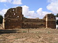 ruins at Ain-Djoukar.
 -
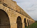


Remains of the aqueduct of Zaghouan can be seen today.[5][6][7]
See also[edit]
References[edit]
- ^ Aïn Djoukar: Tunisia.
- ^ Aïn Jougar - Chinci.com Archived 2016-12-23 at the Wayback Machine.
- ^ Ain Djoukar at getamap.net.
- ^ Pierre-Louis Viollet, Water Engineering in Ancient Civilizations: 5,000 Years of History (CRC Press, 1 Jul. 2007) p151.
- ^ Carte de l'Atlas archéolgique de la Tunisie: Feuille 42 , footnote 16-17.
- ^ Barrington Atlas, 2000, pl. 32 E4
- ^ pictures of the Aqueduct.