
St Peter's Square tram stop
St Peter's Square | ||||||||||||||||||||||||||||||||||||||||||||||||||||||||||||||||||||||||||||||||||||||||||||||||||||||||||||||||||||||||||||||
|---|---|---|---|---|---|---|---|---|---|---|---|---|---|---|---|---|---|---|---|---|---|---|---|---|---|---|---|---|---|---|---|---|---|---|---|---|---|---|---|---|---|---|---|---|---|---|---|---|---|---|---|---|---|---|---|---|---|---|---|---|---|---|---|---|---|---|---|---|---|---|---|---|---|---|---|---|---|---|---|---|---|---|---|---|---|---|---|---|---|---|---|---|---|---|---|---|---|---|---|---|---|---|---|---|---|---|---|---|---|---|---|---|---|---|---|---|---|---|---|---|---|---|---|---|---|---|
| Manchester Metrolink tram stop | ||||||||||||||||||||||||||||||||||||||||||||||||||||||||||||||||||||||||||||||||||||||||||||||||||||||||||||||||||||||||||||||
.jpg) | ||||||||||||||||||||||||||||||||||||||||||||||||||||||||||||||||||||||||||||||||||||||||||||||||||||||||||||||||||||||||||||||
| General information | ||||||||||||||||||||||||||||||||||||||||||||||||||||||||||||||||||||||||||||||||||||||||||||||||||||||||||||||||||||||||||||||
| Location | St Peter's Square, Manchester England | |||||||||||||||||||||||||||||||||||||||||||||||||||||||||||||||||||||||||||||||||||||||||||||||||||||||||||||||||||||||||||||
| Coordinates | 53°28′42″N 2°14′35″W / 53.4782°N 2.2430°W | |||||||||||||||||||||||||||||||||||||||||||||||||||||||||||||||||||||||||||||||||||||||||||||||||||||||||||||||||||||||||||||
| Grid reference | SJ839979 | |||||||||||||||||||||||||||||||||||||||||||||||||||||||||||||||||||||||||||||||||||||||||||||||||||||||||||||||||||||||||||||
| Line(s) | First City Crossing Second City Crossing | |||||||||||||||||||||||||||||||||||||||||||||||||||||||||||||||||||||||||||||||||||||||||||||||||||||||||||||||||||||||||||||
| Platforms | 4 | |||||||||||||||||||||||||||||||||||||||||||||||||||||||||||||||||||||||||||||||||||||||||||||||||||||||||||||||||||||||||||||
| Other information | ||||||||||||||||||||||||||||||||||||||||||||||||||||||||||||||||||||||||||||||||||||||||||||||||||||||||||||||||||||||||||||||
| Status | In operation | |||||||||||||||||||||||||||||||||||||||||||||||||||||||||||||||||||||||||||||||||||||||||||||||||||||||||||||||||||||||||||||
| Fare zone | 1 | |||||||||||||||||||||||||||||||||||||||||||||||||||||||||||||||||||||||||||||||||||||||||||||||||||||||||||||||||||||||||||||
| History | ||||||||||||||||||||||||||||||||||||||||||||||||||||||||||||||||||||||||||||||||||||||||||||||||||||||||||||||||||||||||||||||
| Original company | Manchester Metrolink | |||||||||||||||||||||||||||||||||||||||||||||||||||||||||||||||||||||||||||||||||||||||||||||||||||||||||||||||||||||||||||||
| Key dates | ||||||||||||||||||||||||||||||||||||||||||||||||||||||||||||||||||||||||||||||||||||||||||||||||||||||||||||||||||||||||||||||
| 27 April 1992 | Opened | |||||||||||||||||||||||||||||||||||||||||||||||||||||||||||||||||||||||||||||||||||||||||||||||||||||||||||||||||||||||||||||
| 2015-2016 | Rebuilt | |||||||||||||||||||||||||||||||||||||||||||||||||||||||||||||||||||||||||||||||||||||||||||||||||||||||||||||||||||||||||||||
| ||||||||||||||||||||||||||||||||||||||||||||||||||||||||||||||||||||||||||||||||||||||||||||||||||||||||||||||||||||||||||||||
| ||||||||||||||||||||||||||||||||||||||||||||||||||||||||||||||||||||||||||||||||||||||||||||||||||||||||||||||||||||||||||||||

St Peter's Square is a tram stop in St Peter's Square in Manchester city centre, England. It opened on 27 April 1992 and is in Zone 1 of Greater Manchester's Metrolink light rail system.
The stop's platforms were extended in 2009, but later redevelopment in 2015–16 demolished the original two side platforms and replaced them with a twin-island platform layout, which allows for limited cross-platform interchange. The stop is the most used on the Metrolink network.[1]
History[edit]
Plans for a rapid transit station in St Peter's Square were made in the 1970s; proposals for the abandoned Picc-Vic tunnel envisaged the construction of an underground station to serve both St Peter's and the neighbouring Albert Square.[2] The early proposals for an on-street light rail system in Manchester revived the idea of a station in the square. St. Peter's Square was one of the original city-centre stops to open when Metrolink started operations in 1992, when it consisted of two side [3]platforms and basic shelters. In common with most newly built Metrolink stops at the time, St. Peter's Square had two-level platforms, meaning only a short section of the platforms offered level boarding.
The stop was demolished and rebuilt with a full length platform and improved passenger facilities in November 2009. When a building called Elisabeth House, which had stood between Dickinson Street and Oxford Street since the 1970s, was demolished for redevelopment in 2011 as One St Peter's Square,[4] architects' plans were entered in a competition, which was modified in 2011 to incorporate proposals to improve the Metrolink station. In March 2012 a shortlist of two submissions was made.[5]
The stop closed after end of service on 25 June 2015 for 14 months to allow for a total redevelopment to incorporate trams on the new Second City Crossing.[6] The tram stop re-opened on 28 August 2016 as a four-platform interchange, comprising two island platforms, one for inbound services and the other for outbound. This offers same-direction cross-platform interchange. The stop was moved slightly north towards Princess Street from that of its old location, which was in front of Manchester Central Library. A number of trees were planted within the structure of the platforms to improve the look and feel of the space.[7] The Manchester Cenotaph was also relocated and the entire square has been redeveloped into a new public space. During the redevelopment works, a reduced service ran through the square on a single track[8] from Nicholas Street to Windmill Street[9] - but there were two 2-month long closures at the beginning and end of the project.[10] During these full closures, no Metrolink services ran through the square. The rebuilding work uncovered the remnants of an 18th century church crypt.[11]
Deansgate-Castlefield – St Peter's Square | ||||||||||||||||||||||||||||||||||||||||||||||||||||||||||||||||||||||||||||||||||||||||||||||||||||||||||||||||||||||||||||||||||||||||||||||||||||||||||||||||
|---|---|---|---|---|---|---|---|---|---|---|---|---|---|---|---|---|---|---|---|---|---|---|---|---|---|---|---|---|---|---|---|---|---|---|---|---|---|---|---|---|---|---|---|---|---|---|---|---|---|---|---|---|---|---|---|---|---|---|---|---|---|---|---|---|---|---|---|---|---|---|---|---|---|---|---|---|---|---|---|---|---|---|---|---|---|---|---|---|---|---|---|---|---|---|---|---|---|---|---|---|---|---|---|---|---|---|---|---|---|---|---|---|---|---|---|---|---|---|---|---|---|---|---|---|---|---|---|---|---|---|---|---|---|---|---|---|---|---|---|---|---|---|---|---|---|---|---|---|---|---|---|---|---|---|---|---|---|---|---|---|
| ||||||||||||||||||||||||||||||||||||||||||||||||||||||||||||||||||||||||||||||||||||||||||||||||||||||||||||||||||||||||||||||||||||||||||||||||||||||||||||||||
-
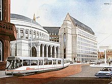 An artist's impression of light rail in St Peter's Square (1987)
 -
 T-68 Tram at the old St Peter's Square tram stop in 1992.
 -
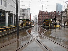 The rebuilt four platform stop, 2018


Services[edit]
Services run every 12 minutes on each route.
| Preceding station | Following station | |||
|---|---|---|---|---|
| Deansgate-Castlefield towards East Didsbury
|
East Didsbury–Shaw (peak only) | Exchange Square towards Shaw and Crompton
| ||
| East Didsbury–Rochdale | Exchange Square towards Rochdale Town Centre
| |||
| Deansgate-Castlefield towards Manchester Airport
|
Manchester Airport–Victoria | Market Street towards Victoria
| ||
| Deansgate-Castlefield towards Altrincham
|
Altrincham–Bury (peak only) | Market Street towards Bury
| ||
| Altrincham–Piccadilly | Piccadilly Gardens towards Piccadilly
| |||
| Altrincham–Etihad Campus (evenings and Sundays only) | Piccadilly Gardens towards Etihad Campus
| |||
| Deansgate-Castlefield towards Eccles
|
Eccles–Ashton (peak only) | Piccadilly Gardens towards Ashton-under-Lyne
| ||
| Eccles–Ashton via MediaCityUK (off-peak only) | ||||
| Deansgate-Castlefield towards MediaCityUK
|
MediaCityUK–Etihad Campus (peak only) | Piccadilly Gardens towards Etihad Campus
| ||
References[edit]
- ^ "Transport Statistics Greater Manchester 2017 Public Transport Section". TfGM. 5 December 2019. Retrieved 14 December 2019.
- ^ SELNEC PTE (October 1971), SELNEC Picc-Vic Line, SELNEC PTE publicity brochure
- ^ International2016-09-02T11:07:00+01:00, Railway Gazette. "Manchester Metrolink opens expanded St Peter's Square stop". Railway Gazette International. Retrieved 24 May 2024.
{{cite web}}: CS1 maint: numeric names: authors list (link) - ^ "Elizabeth House". Cool Manchester. Retrieved 24 March 2012.
- ^ One St Peter's Square; E-architect
- ^ "St Peter's Square Metrolink stop to reopen after a year". BBC News. 27 August 2016. Archived from the original on 28 August 2016. Retrieved 14 March 2020.
- ^ "One month to go for St Peter's Square tram works". Place North West. 27 July 2016. Archived from the original on 28 July 2016.
- ^ "Next stop, St. Peter's Square" (PDF). 8 April 2016. Archived from the original (PDF) on 4 August 2016. Retrieved 15 March 2020.
- ^ GM Trainspotting (26 June 2016). Metrolink Driver's Eye View - Market Street to Deansgate-Castlefield. Retrieved 18 May 2024 – via YouTube.
- ^ "St Peter's Square stop closure: Metrolink and shuttle bus services". Transport for Greater Manchester. TfGM. 29 June 2015. Archived from the original on 8 August 2015.
- ^ Helen Heath (15 February 2017). "Bishop of Manchester rededicates cross in St Peter's square". thenorthernquota.org. Retrieved 14 March 2020.
External links[edit]
- Tram times and station information for St Peter's Square Metrolink station from Manchester Metrolink
- St Peter's Square area map
Manchester railways |
|---|
City Centre and North
Past, present and future |
| Tram stops |
|   | ||||||||||||||||||||||||
|---|---|---|---|---|---|---|---|---|---|---|---|---|---|---|---|---|---|---|---|---|---|---|---|---|---|---|
| Operations |
| |||||||||||||||||||||||||
| History (Timeline) |
| |||||||||||||||||||||||||
| Proposed developments |
| |||||||||||||||||||||||||
- Tram stops in Manchester
- Railway stations in Great Britain opened in 1992
- Tram stops on the Eccles – Ashton route
- Tram stops on the East Didsbury – Shaw route
- Tram stops on the East Didsbury – Rochdale route
- Tram stops on the Altrincham – Bury route
- Tram stops on the Altrincham – Piccadilly/Etihad Campus route
- Tram stops on the Manchester Airport – Victoria route
- Tram stops on the MediaCityUK – Etihad Campus route