
Sibayo District
Sibayo | |
|---|---|
 The main plaza of Sibayo | |
 Sibayo Location of Sibayo in the Caylloma province | |
| Coordinates: 15°29′12.1″S 71°27′25.7″W / 15.486694°S 71.457139°W | |
| Country | |
| Region | Arequipa |
| Province | Caylloma |
| Founded | January 25, 1943 |
| Capital | Sibayo |
| Government | |
| • Mayor | Raul Meliton Mamani Picha |
| Area | |
| • Total | 286.03 km2 (110.44 sq mi) |
| Elevation | 3,810 m (12,500 ft) |
| Population | |
| • Total | 1,493 |
| • Density | 5.2/km2 (14/sq mi) |
| Time zone | UTC-5 (PET) |
| UBIGEO | 040515 |
Sibayo District is one of twenty districts of the province Caylloma in Peru.[1] It is adjacent to Callalli and crossed by the Colca River on one side.
Ethnic groups[edit]
The people in the district are mainly indigenous citizens of Quechua descent. Quechua is the language which the majority of the population (55.45%) learnt to speak in childhood, 44.41% of the residents started speaking using the Spanish language (2007 Peru Census).[2]
-
 The village of Sibayo as seen from above
 -
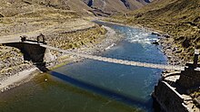 Sibayo's suspended pedestrian bridge
 -
 The main plaza in Sibayo as seen from above
 -
 The entrance to Sibayo in the Colca Canyon
 -
 Sibayo's ruins next to the Colca river.


See also[edit]
References[edit]
- ^ (in Spanish) Instituto Nacional de Estadística e Informática. Banco de Información Distrital Archived 2008-04-23 at the Wayback Machine. Retrieved April 11, 2008.
- ^ inei.gob.pe Archived 2013-01-27 at the Wayback Machine INEI, Peru, Censos Nacionales 2007, Frequencias: Preguntas de Población: Idioma o lengua con el que aprendió hablar (in Spanish)
15°29′35″S 71°44′46″W / 15.4931°S 71.7462°W
This Arequipa Region geography article is a stub. You can help Wikipedia by expanding it. |