
Portal:World
The World Portal


The world is the totality of entities, the whole of reality, or everything that exists. The nature of the world has been conceptualized differently in different fields. Some conceptions see the world as unique while others talk of a "plurality of worlds". Some treat the world as one simple object while others analyze the world as a complex made up of parts.
In scientific cosmology, the world or universe is commonly defined as "[t]he totality of all space and time; all that is, has been, and will be". Theories of modality talk of possible worlds as complete and consistent ways how things could have been. Phenomenology, starting from the horizon of co-given objects present in the periphery of every experience, defines the world as the biggest horizon or the "horizon of all horizons". In philosophy of mind, the world is contrasted with the mind as that which is represented by the mind. Theology conceptualizes the world in relation to God, for example, as God's creation, as identical to God or as the two being interdependent. In religions, there is a tendency to downgrade the material or sensory world in favor of a spiritual world to be sought through religious practice. A comprehensive representation of the world and our place in it, as is found in religions, is known as a worldview. Cosmogony is the field that studies the origin or creation of the world while eschatology refers to the science or doctrine of the last things or of the end of the world.
In various contexts, the term "world" takes a more restricted meaning associated, for example, with the Earth and all life on it, with humanity as a whole or with an international or intercontinental scope. In this sense, world history refers to the history of humanity as a whole and world politics is the discipline of political science studying issues that transcend nations and continents. Other examples include terms such as "world religion", "world language", "world government", "world war", "world population", "world economy", or "world championship". (Full article...)
Selected articles -
-
 "We Are the World" is a charity single originally recorded by the supergroup USA for Africa in 1985. It was written by Michael Jackson and Lionel Richie and produced by Quincy Jones and Michael Omartian for the album We Are the World. With sales in excess of 20 million copies, it is the eighth-best-selling physical single of all time.
Soon after the British group Band Aid released "Do They Know It's Christmas?" in December 1984, the musician and activist Harry Belafonte decided to create an American benefit single for African famine relief. With the fundraiser Ken Kragen, he enlisted several musicians. Jackson and Richie completed the writing the night before the first recording session, on January 21, 1985. The event brought together some of the era's best-known musicians. (Full article...) -
A global issue is a matter of public concern worldwide. This list of global issues presents problems or phenomena affecting people around the world, including but not limited to widespread social issues, economic issues, and environmental issues. Organizations that maintain or have published an official list of global issues include the United Nations, and the World Economic Forum. (Full article...)
-
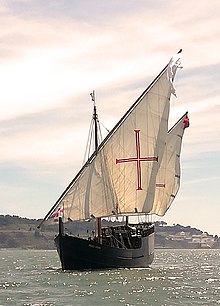
A replica of the Portuguese caravel Caravela Vera Cruz. These small, highly manoeuverable ships played an important role in overseas exploration.
The Age of Discovery also known as the Age of Exploration, part of the early modern period and largely overlapping with the Age of Sail, was a period from approximately the 15th century to the 17th century, during which seafarers from a number of European countries explored, colonized, and conquered regions across the globe. The Age of Discovery was a transformative period in world history when previously isolated parts of the world became connected to form the world system and laid the groundwork for globalization. The extensive overseas exploration, particularly the European colonization of the Americas, with the Spanish and Portuguese, and later the British, at the forefront, spurred global trade. The interconnected global economy of the 21st century has its roots in the expansion of trade networks during this era.
The exploration also created colonial empires and marked an increased adoption of colonialism as a government policy in several European states. As such, it is sometimes synonymous with the first wave of European colonization. The colonization reshaped power dynamics causing geopolitical shifts in Europe and creating new centers of power beyond Europe. Having set human history on the global common course, the legacy of the Age still shapes the world today. (Full article...) -
The FIFA Women's World Cup is an international association football competition contested by the senior women's national teams of the members of Fédération Internationale de Football Association (FIFA), the sport's international governing body. The competition has been held every four years and one year after the men's FIFA World Cup since 1991, when the inaugural tournament, then called the FIFA Women's World Championship, was held in China. Under the tournament's current format, national teams vie for the remaining 31 slots in a three-year qualification phase. The host nation's team is automatically entered as the first slot. The tournament, called the World Cup Finals, is contested at venues within the host nation(s) over about one month.
The nine FIFA Women's World Cup tournaments have been won by five national teams. The United States have won four times. The other winners are Germany, with two titles, and Japan, Norway, and Spain with one title each. (Full article...) -

EU protected designation of origin logo
The protected designation of origin (PDO) is a type of geographical indication of the European Union aimed at preserving the designations of origin of food-related products. The designation was created in 1992 and its main purpose is to designate products that have been produced, processed and developed in a specific geographical area, using the recognized know-how of local producers and ingredients from the region concerned.
The list below also shows other geographical indications. (Full article...) -

The Space Race was a 20th-century competition between two Cold War rivals, the United States and the Soviet Union, to achieve superior spaceflight capability. It had its origins in the ballistic missile-based nuclear arms race between the two nations following World War II and had its peak with the more particular Moon Race to land on the Moon between the US moonshot and Soviet moonshot programs. The technological advantage demonstrated by spaceflight achievement was seen as necessary for national security and became part of the symbolism and ideology of the time. The Space Race brought pioneering launches of artificial satellites, robotic space probes to the Moon, Venus, and Mars, and human spaceflight in low Earth orbit and ultimately to the Moon.
Public interest in space travel originated in the 1951 publication of a Soviet youth magazine and was promptly picked up by US magazines. The competition began on July 30, 1955, when the United States announced its intent to launch artificial satellites for the International Geophysical Year. Four days later, the Soviet Union responded by declaring they would also launch a satellite "in the near future". The launching of satellites was enabled by developments in ballistic missile capabilities since the end of World War II. The competition gained Western public attention with the "Sputnik crisis", when the USSR achieved the first successful satellite launch, Sputnik 1, on October 4, 1957. It gained momentum when the USSR sent the first human, Yuri Gagarin, into space with the orbital flight of Vostok 1 on April 12, 1961. These were followed by a string of other early firsts achieved by the Soviets over the next few years. (Full article...) -
Water covers about 71% of Earth's surface.
The origin of water on Earth is the subject of a body of research in the fields of planetary science, astronomy, and astrobiology. Earth is unique among the rocky planets in the Solar System in having oceans of liquid water on its surface. Liquid water, which is necessary for all known forms of life, continues to exist on the surface of Earth because the planet is at a far enough distance (known as the habitable zone) from the Sun that it does not lose its water, but not so far that low temperatures cause all water on the planet to freeze.
It was long thought that Earth's water did not originate from the planet's region of the protoplanetary disk. Instead, it was hypothesized water and other volatiles must have been delivered to Earth from the outer Solar System later in its history. Recent research, however, indicates that hydrogen inside the Earth played a role in the formation of the ocean. The two ideas are not mutually exclusive, as there is also evidence that water was delivered to Earth by impacts from icy planetesimals similar in composition to asteroids in the outer edges of the asteroid belt. (Full article...)


General images -
-
 A pillar at Göbekli Tepe
 -
 A banded iron formation from the 3.15 Ga Moodies Group, Barberton Greenstone Belt, South Africa. Red layers represent the times when oxygen was available; gray layers were formed in anoxic circumstances. (from History of Earth)
 -
 The Pantheon, originally a Roman temple, now a Catholic church
 -
 Earth's western hemisphere showing topography relative to Earth's center instead of to mean sea level, as in common topographic maps (from Earth)
 -
 A composite image of Earth, with its different types of surface discernible: Earth's surface dominating Ocean (blue), Africa with lush (green) to dry (brown) land and Earth's polar ice in the form of Antarctic sea ice (grey) covering the Antarctic or Southern Ocean and the Antarctic ice sheet (white) covering Antarctica. (from Earth)
 -

-
 Japanese depiction of a Portuguese carrack. European maritime innovations led to proto-globalization.
 -

-
 Earth's land use for human agriculture in 2019 (from Earth)
 -
 Change in average surface air temperature and drivers for that change. Human activity has caused increased temperatures, with natural forces adding some variability. (from Earth)
 -
 An artist's impression of the Archean, the eon after Earth's formation, featuring round stromatolites, which are early oxygen-producing forms of life from billions of years ago. After the Late Heavy Bombardment, Earth's crust had cooled, its water-rich barren surface is marked by continents and volcanoes, with the Moon still orbiting Earth half as far as it is today, appearing 2.8 times larger and producing strong tides. (from Earth)
 -
 Tiktaalik, a fish with limb-like fins and a predecessor of tetrapods. Reconstruction from fossils about 375 million years old. (from History of Earth)
 -
 Great Pyramids of Giza, Egypt
 -
 Taj Mahal, Mughal Empire, India
 -
 Empires of the world in 1898
 -
 Shanghai. China urbanized rapidly in the 21st century.
 -
 A map of heat flow from Earth's interior to the surface of Earth's crust, mostly along the oceanic ridges (from Earth)
 -
 A reconstruction of human history based on fossil data. (from History of Earth)
 -
 Pale orange dot, an artist's impression of Early Earth, featuring its tinted orange methane-rich early atmosphere (from Earth)
 -
 Earth's history with time-spans of the eons to scale (from History of Earth)
 -
 A computer-generated image mapping the prevalence of artificial satellites and space debris around Earth in geosynchronous and low Earth orbit (from Earth)
 -
 Lithified stromatolites on the shores of Lake Thetis, Western Australia. Archean stromatolites are the first direct fossil traces of life on Earth. (from History of Earth)
 -
 A view of Earth with its global ocean and cloud cover, which dominate Earth's surface and hydrosphere; at Earth's polar regions, its hydrosphere forms larger areas of ice cover. (from Earth)
 -
 Trilobites first appeared during the Cambrian period and were among the most widespread and diverse groups of Paleozoic organisms. (from History of Earth)
 -
 Artist's impression of the enormous collision that probably formed the Moon (from History of Earth)
 -
 An artist's rendering of a protoplanetary disk (from History of Earth)
 -
 An artist's impression of ice age Earth at glacial maximum. (from History of Earth)
 -
 Battle during 1281 Mongol invasion of Japan
 -
 Last Moon landing: Apollo 17 (1972)
 -
 Machu Picchu, Inca Empire, Peru
 -
 A reconstruction of Pannotia (550 Ma). (from History of Earth)
 -
Artist's impression of Earth during the later Archean, the largely cooled planetary crust and water-rich barren surface, marked by volcanoes and continents, features already round microbialites. The Moon, still orbiting Earth much closer than today and still dominating Earth's sky, produced strong tides. (from History of Earth)
-
 Earth's axial tilt causing different angles of seasonal illumination at different orbital positions around the Sun (from Earth)
 -
 Artist's conception of Hadean Eon Earth, when it was much hotter and inhospitable to all forms of life. (from History of Earth)
 -
 Pangaea was a supercontinent that existed from about 300 to 180 Ma. The outlines of the modern continents and other landmasses are indicated on this map. (from History of Earth)
 -

-

-
 Obelisk of Axum, Ethiopia
 -
 Artist's rendition of an oxinated fully-frozen Snowball Earth with no remaining liquid surface water. (from History of Earth)
 -
 Olmec colossal head, now at the Museo de Antropología de Xalapa
 -
 Great Mosque of Kairouan, Tunisia, founded 670 CE
 -

-
 A schematic view of Earth's magnetosphere with solar wind flowing from left to right (from Earth)
 -
 Cross-section through a liposome (from History of Earth)
 -

-
 View of Earth from the Moon by the Lunar Reconnaissance Orbiter (from Earth)
 -

-
 Angkor Wat temple complex, Cambodia, early 12th century
 -
 Florence, birthplace of the Italian Renaissance
 -
 A view of Earth with different layers of its atmosphere visible: the troposphere with its clouds casting shadows, a band of stratospheric blue sky at the horizon, and a line of green airglow of the lower thermosphere around an altitude of 100 km, at the edge of space (from Earth)
 -
 Artist's conception of Devonian flora (from History of Earth)
 -

-

-

-
 Fall of the Berlin Wall, 1989
 -

-
 Chloroplasts in the cells of a moss (from History of Earth)
 -
 Graph showing range of estimated partial pressure of atmospheric oxygen through geologic time (from History of Earth)
 -
 Chennakesava Temple, Belur, India
 -
 Map of peopling of the world (Southern Dispersal paradigm), in thousands of years ago.
 -
 Standing Buddha from Gandhara, 2nd century CE
 -
 Persepolis, Achaemenid Empire, 6th century BCE
 -
The pale orange dot, an artist's impression of the early Earth which might have appeared orange through its hazy methane rich prebiotic second atmosphere. Earth's atmosphere at this stage was somewhat comparable to today's atmosphere of Titan. (from History of Earth)
-
 A Benin Bronze head from Nigeria
 -
 Tracy Caldwell Dyson, a NASA astronaut, observing Earth from the Cupola module at the International Space Station on 11 September 2010 (from Earth)
 -
 First airplane, the Wright Flyer, flew on 17 December 1903.
 -
 Artist's impression of a Hadean landscape with the relatively newly formed Moon still looming closely over Earth and both bodies sustaining strong volcanism. (from History of Earth)
 -
 Earth's night-side upper atmosphere appearing from the bottom as bands of afterglow illuminating the troposphere in orange with silhouettes of clouds, and the stratosphere in white and blue. Next the mesosphere (pink area) extends to the orange and faintly green line of the lowest airglow, at about one hundred kilometers at the edge of space and the lower edge of the thermosphere (invisible). Continuing with green and red bands of aurorae stretching over several hundred kilometers. (from Earth)
 -

-
 Geologic map of North America, color-coded by age. From most recent to oldest, age is indicated by yellow, green, blue, and red. The reds and pinks indicate rock from the Archean.
 -

-

-
 Vitruvian Man by Leonardo da Vinci epitomizes the advances in art and science seen during the Renaissance. (from History of Earth)
 -
 A composite image of artificial light emissions at night on a map of Earth (from Earth)
 -
 A 2012 artistic impression of the early Solar System's protoplanetary disk from which Earth and other Solar System bodies were formed (from Earth)
 -
 Ming dynasty section, Great Wall of China
 -
 An animation of the changing density of productive vegetation on land (low in brown; heavy in dark green) and phytoplankton at the ocean surface (low in purple; high in yellow) (from Earth)
 -
 The replicator in virtually all known life is deoxyribonucleic acid. DNA is far more complex than the original replicator and its replication systems are highly elaborate. (from History of Earth)
 -

-
 Ajloun Castle, Jordan
 -
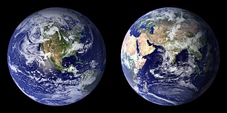
 Image of the physical world, captured by the Hubble Space Telescope (from World)
 -
 "Lucy", the first Australopithecus afarensis skeleton found. Lucy was only 1.06 m (3 ft 6 in) tall.
 -

-

-

-

-
 Dinosaurs were the dominant terrestrial vertebrates throughout most of the Mesozoic (from History of Earth)
 -

-
 Yggdrasil, an attempt to reconstruct the Norse world tree which connects the heavens, the world, and the underworld. (from World)
 -
 Satellite time lapse imagery of Earth's rotation showing axis tilt (from Earth)
 -
 A 580 million year old fossil of Spriggina floundensi, an animal from the Ediacaran period. Such life forms could have been ancestors to the many new forms that originated in the Cambrian Explosion. (from History of Earth)
 -
 Notre-Dame de Paris, France


.svg)


.jpeg)


.jpg)


.jpg)
.jpg)


Megacities of the world -

Nagoya (名古屋市, Nagoya-shi, [naꜜɡoja] ⓘ) is the largest city in the Chūbu region, the fourth-most populous city proper with a population of 2.3 million in 2020, and the principal city of the Chūkyō metropolitan area, which is the third-most populous metropolitan area in Japan with a population of 10.11 million. Located on the Pacific coast in central Honshu, it is the capital and most populous city of Aichi Prefecture, with the Port of Nagoya being Japan's largest seaport.
In 1610, the warlord Tokugawa Ieyasu, a retainer of Oda Nobunaga, moved the capital of Owari Province from Kiyosu to Nagoya. This period saw the renovation of Nagoya Castle. The arrival of the 20th century brought a convergence of economic factors that fueled rapid growth in Nagoya, during the Meiji Restoration, and became a major industrial hub for Japan. The traditional manufactures of timepieces, bicycles, and sewing machines were followed by the production of special steels, ceramic, chemicals, oil, and petrochemicals, as the area's automobile, aviation, and shipbuilding industries flourished. These factors made the city a target for US air raids during World War II. (Full article...)Did you know -

- ... that during World War II, Terry Sanford captured a German officer by grabbing him by the belt?
- ... that Gateshead Millennium Bridge is the world's first tilt bridge?
- ... that more than a decade after Edgar Wright assembled the cast of Scott Pilgrim vs. the World, he helped to convince them all to reprise their roles in an anime adaptation of the source material?
- ... that Austrian master metalsmith Cyril Colnik chose to close his shop rather than make armaments for World War I?
- ... that there are only about 30 Ancient Egyptian obelisks left standing worldwide—and Italy has more than Egypt?
- ... that Michaela Foster, a New Zealand footballer playing in the 2023 World Cup, is known for her mana?
- ... that Muhsin Hendricks of South Africa has been described as "the world's first openly gay imam"?
- ... that an Elvin man sang Poems and Songs of Middle Earth?
Countries of the world -

Cape Verde (/ˈvɜːrd(i)/ ⓘ, VURD or VUR-dee) or Cabo Verde (/ˌkɑːboʊ ˈvɜːrdeɪ/ ⓘ, /ˌkæb-/ KA(H)B-oh VUR-day; Portuguese: [ˈkaβu ˈveɾðɨ]), officially the Republic of Cabo Verde, is an archipelago and island country of West Africa in the central Atlantic Ocean, consisting of ten volcanic islands with a combined land area of about 4,033 square kilometres (1,557 sq mi). These islands lie between 600 and 850 kilometres (320 and 460 nautical miles) west of Cap-Vert, the westernmost point of continental Africa. The Cape Verde islands form part of the Macaronesia ecoregion, along with the Azores, the Canary Islands, Madeira and the Savage Isles.
The Cape Verde archipelago was uninhabited until the 15th century, when Portuguese explorers discovered and colonized the islands, thus establishing the first European settlement in the tropics. Because the Cape Verde islands were conveniently located to play a role in the Atlantic slave trade, Cape Verde became economically prosperous during the 16th and 17th centuries, attracting merchants, privateers, and pirates. It declined economically in the 19th century after the suppression of the Atlantic slave trade by the British Empire, and many of its inhabitants emigrated during that period. However, Cape Verde gradually recovered economically by becoming an important commercial center and useful stopover point along major shipping routes. Cape Verde became independent in 1975. (Full article...)Related portals
Protected areas of the world -
-
The country of Burundi in Africa has the following national parks and other protected areas. (Full article...)
-
The Valley of the Giants skywalk at Walpole-Nornalup National Park
Western Australia is the second largest country subdivision in the world.
As of 2022, based on the latest Collaborative Australian Protected Areas Database report, it contains 1857 separate land-based protected areas with a total area of 76,142,710 hectares (188,152,700 acres), accounting for just over 30 percent of the state's land mass. By area, Indigenous Protected Areas account for the largest part of this, almost 67 percent while, by number, nature reserves hold the majority with two-third of all land-based protected areas being nature reserves. (Full article...) -
Protected areas of Sri Lanka are administrated by Department of Forest Conservation and Department of Wildlife Conservation of Sri Lanka.There are 501 protected areas in Sri Lanka. The protected areas that fall under supervision of the Department of Forest Conservation include forests defined in National Heritage Wilderness Area Act in 1988, forest reservations, and forests managed for sustainability. Sinharaja Forest Reserve is an example for a National Heritage forest (it is also a World Heritage Site). There are 32 forests categorized as conservation forests including Knuckles Mountain Range. Strict nature reserves, national parks, nature reserves, forest corridors, and sanctuaries recognized under the Flora and Fauna Protection Ordinance are managed by Department of Wildlife Conservation. Total of all protected areas is 1,767,000 ha. Protected areas in Sri Lanka account for 26.5 percent of the total area. This is a higher percentage of protected areas than in all of Asia and much of the World. (Full article...)
-
This is a list of protected areas of Sierra Leone, including national parks, game reserves, conservation areas, wetlands, and those that are listed as proposed protected areas in the UN Environment Programme World Conservation Monitoring Centre (UNEP WCM) database. (Full article...)
-
The Protected areas of Portugal (Portuguese: Áreas protegidas de Portugal) are classified under a legal protection statute that allows for the adequate protection and maintenance of biodiversity, while providing services for ecosystem that maintains the natural and geological patrimony. (Full article...)
-
There are four categories of protected areas in India, constituted under the Wildlife Protection Act, 1972. Tiger reserves consist of areas under national parks and wildlife sanctuaries. There are 53 tiger reserves in India. the protected areas of India cover 173,629.52 square kilometres (67,038.73 sq mi), roughly 5.28% of the total geographical area of the country. (Full article...)
-
Forests in the state of Himachal Pradesh (northern India) currently cover an area of nearly 37,939 square kilometres (14,648 sq mi), which is about 68.16% of the total land area of the state. The forests were once considered to be the main source of income of the state and most of the original forests were clear felled. The emphasis has shifted, however, from exploitation to conservation. The state government aims to increase forest cover to 50% of the total land area. There have been various projects, including the establishment of protected areas such as National Parks, designed to preserve and expand the forests. (Full article...)
-
Cadw is the historic environment service of the Welsh Government which manages historical buildings and ancient monuments in Wales. (Full article...)
-

A view of Kaptai National Park
This is a list of protected areas of Bangladesh. Bangladesh is a country in South Asia. It is the eighth-most populous country in the world, with a population exceeding 163 million people in an area of either 148,460 square kilometres (57,320 sq mi) or 147,570 square kilometres (56,980 sq mi), making it one of the most densely populated countries in the world. (Full article...) -
This is a list of protected areas of Afghanistan.
- Ab-i-Estada Nature Reserve, Ghazni Province
- Ajar Valley Nature Reserve, Bamyan Province
- Bamiyan National Heritage Park, Bamyan Province
- Bamiyan Plateau Protected Landscape, Bamyan Province
- Band-e Amir National Park, Bamyan Province
- Darqad (Takhar) Wildlife Reserve, Takhar Province
- Dasht-i-Nawar Waterfowl Sanctuary, Ghazni Province
- Hamun-i-Puzak Waterfowl Sanctuary, Farah and Nimroz provinces
- Imam Sahib (Kunduz) Wildlife Reserve, Kunduz Province
- Khulm Landmark Protected Area, Balkh Province
- Koh-e Baba (Shah Foladi) Protected Landscape, Bamyan province
- Kol-i-Hashmat Khan Waterfowl Sanctuary, Kabul Province
- Northwest Afghanistan Game Managed Reserve, Herat Province
- Nuristan National Park and Wildlife Reserve, Nuristan Province
- Pamir-i-Buzurg Wildlife Reserve, Badakhshan Province
- Registan Desert Wildlife Managed Reserve, Kandahar Province
- Wakhan National Park, Badakhshan Province
- Zadran National Reserve, Paktia Province
-
The Protected areas of New South Wales include both terrestrial and marine protected areas. there are 225 national parks in New South Wales. A number established since the late 1970s followed campaigns by local residents and environmentalists.
Based on the Collaborative Australian Protected Area Database (CAPAD) 2020 data there are 2136 separate terrestrial protected areas with a total land area of 7,696,641 hectares (19,018,810 acres) (9.61% of the state's area). CAPAD data also shows 18 marine protected areas with a total area of 348,849 hectares (862,020 acres), covering 39.63% of NSW waters. (Full article...) -
Protected areas of Turkmenistan include nine nature reserves (zapovednik) and 13 sanctuaries (zakaznik) with a total area of 19,750 km2 or more than 4% of Turkmenistan's territory. (Full article...)
-
The Protected areas of Kyrgyzstan are regulated by the law on specially protected natural areas of 2 May 2011, last modified on 2 June 2018. In total, they cover 14,761.216 km2 (5,699.337 sq mi) and account for 7.38% of the country's total area (as of 2017). The first protected area in Kyrgyzstan (Issyk-Kul) was established in 1948. According to the Government Decree on Priorities of Conservation of Biological Diversity and the relevant Action Plan for 2014-2024 the target area for the protected areas in Kyrgyzstan is 10 percent of the country’s area by 2024.
The protected areas are subdivided into seven categories: (Full article...) -

Grand Canyon of Yellowstone
The protected areas of the United States are managed by an array of different federal, state, tribal and local level authorities and receive widely varying levels of protection. Some areas are managed as wilderness, while others are operated with acceptable commercial exploitation. , the 42,826 protected areas covered 1,235,486 km2 (477,024 sq mi), or 13 percent of the land area of the United States. This is also one-tenth of the protected land area of the world. The U.S. also had a total of 871 National Marine Protected Areas, covering an additional 1,240,000 sq mi (3,200,000 km2), or 26 percent of the total marine area of the United States. (Full article...) -
Rock carvings at the Ewaninga Rock Carvings Conservation Reserve
The protected areas of the Northern Territory consists of protected areas managed by the governments of the Northern Territory and Australia and private organisations with a reported total area of 335,527 square kilometres (129,548 sq mi) being 24.8% of the total area of the Northern Territory of Australia. (Full article...)


Selected world maps
-
 Mollweide projection of the world
 -
 United Nations Human Development Index map by country (2016)
 -
 A plate tectonics map with volcano locations indicated with red circles
 -
 Index map from the International Map of the World (1:1,000,000 scale)
 -
 The world map by Gerardus Mercator (1569), the first map in the well-known Mercator projection
 -
 Time zones of the world
 -
 Only a few of the largest large igneous provinces appear (coloured dark purple) on this geological map, which depicts crustal geologic provinces as seen in seismic refraction data
 -
 The Goode homolosine projection is a pseudocylindrical, equal-area, composite map projection used for world maps.
 -
 1516 map of the world by Martin Waldseemüller


World records
- List of Olympic records in athletics
- List of world records in athletics
- List of junior world records in athletics
- List of world records in masters athletics
- List of world youth bests in athletics
- List of IPC world records in athletics
- List of world records in canoeing
- List of world records in chess
- List of cycling records
- List of world records in track cycling
- List of world records in finswimming
- List of world records in juggling
- List of world records in rowing
- List of world records in speed skating
- List of world records in swimming
- List of IPC world records in swimming
- List of world records in Olympic weightlifting
Topics

Continents of Earth | ||||||||
|---|---|---|---|---|---|---|---|---|
| ||||||||
| ||||||||
| ||||||||


| Cenozoic Era (present–66.0 Ma) |
| ||||||||||||
|---|---|---|---|---|---|---|---|---|---|---|---|---|---|
| Mesozoic Era (66.0–252 Ma) |
| ||||||||||||
| Paleozoic Era (252–539 Ma) |
| ||||||||||||
| Proterozoic Eon (539 Ma–2.5 Ga) |
| ||||||||||||
| Archean Eon (2.5–4 Ga) | |||||||||||||
| Hadean Eon (4–4.6 Ga) | |||||||||||||
ka = kiloannum (thousands years ago); Ma = megaannum (millions years ago); Ga = gigaannum (billions years ago). See also: Geologic time scale • | |||||||||||||
| Locations | ||
|---|---|---|
| Related | ||

| |||||||||||||||||||
| |||||||||||||||||||
| |||||||||||||||||||

Economic classification of countries | |||||
|---|---|---|---|---|---|
| Three-World Model | |||||
| Gross domestic product (GDP) |
| ||||
| Gross national income (GNI) | |||||
| Wages | |||||
| Wealth | |||||
| Other national accounts | |||||
| Human development | |||||
| Digital divide | |||||
| Net international investment position (NIIP) | |||||
| Technological |
| ||||
|---|---|---|---|---|---|
| Sociological | |||||
| Ecological |
| ||||
| Biological |
| ||||
| Astronomical | |||||
| Eschatological |
| ||||
| Others |
| ||||
| Fictional | |||||
| Organizations | |||||
Categories

Wikimedia
The following Wikimedia Foundation sister projects provide more on this subject:
-
 Commons
Free media repository -
 Wikibooks
Free textbooks and manuals -
 Wikidata
Free knowledge base -
 Wikinews
Free-content news -
 Wikiquote
Collection of quotations -
 Wikisource
Free-content library -
 Wikispecies
Directory of species -
 Wikiversity
Free learning tools -
 Wikivoyage
Free travel guide -
 Wiktionary
Dictionary and thesaurus


