
Arendonk
Arendonk | |
|---|---|
 Villa in Arendonk | |
 Flag  Coat of arms | |
Location of Arendonk  | |
 Arendonk Location in Belgium
Location of Arendonk in the province of Antwerp  | |
| Coordinates: 51°19′N 05°05′E / 51.317°N 5.083°E | |
| Country | |
| Community | Flemish Community |
| Region | Flemish Region |
| Province | Antwerp |
| Arrondissement | Turnhout |
| Government | |
| • Mayor | Kristof Hendrickx (N-VA) |
| • Governing party/ies | N-VA, CD&V |
| Area | |
| • Total | 55.15 km2 (21.29 sq mi) |
| Population (2020-01-01)[1] | |
| • Total | 13,290 |
| • Density | 240/km2 (620/sq mi) |
| Postal codes | 2370 |
| NIS code | 13001 |
| Area codes | 014 |
| Website | www.arendonk.be |

Arendonk (Dutch pronunciation: [ˈaːrəndɔŋk] ⓘ) is a municipality located in the Belgian province of Antwerp. The municipality comprises only the town of Arendonk proper. In 2021, Arendonk had a total population of 13,207. The total area is 55.38 km².[2]
The spoken language is Kempenlands (an East Brabantian dialect, which is very similar to colloquial Dutch).[3]
Nickname[edit]
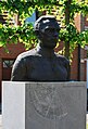
The nickname for a person living in Arendonk is "Telowerelè'er" meaning dish-licker. A statue personating the nickname is located in proximity of the Toremansmolen windmill, another attraction. The mill is still operational and can be visited regularly. The mayor of this city is called Kristof Hendrickx.
Famous inhabitants[edit]
- Rik Van Steenbergen, thrice World Cycling Champion
- René Mertens, cyclist in the 1948 Tour de France[4]
- Karel Meulemans, one of the best pigeonfanciers worldwide
- Janssen Brothers of Schoolstraat, Arendonk - The most famous pigeon fanciers in the World.[5]
- There is a possibility that the Flemish painter Jan van Eyck is originally from Arendonk.[6]
Image gallery[edit]
-
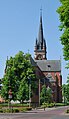 OLV Church Arendonk
 -
 Rik Van Steenbergen
 -
 Telowerelè'er and Toremansmolen
 -
 Arendonk's Academy of art located in a former cigar factory of "Karel I sigaren"


Climate[edit]
| Climate data for Arendonk (1991−2020 normals) | |||||||||||||
|---|---|---|---|---|---|---|---|---|---|---|---|---|---|
| Month | Jan | Feb | Mar | Apr | May | Jun | Jul | Aug | Sep | Oct | Nov | Dec | Year |
| Mean daily maximum °C (°F) | 6.3 (43.3) |
7.3 (45.1) |
11.1 (52.0) |
15.5 (59.9) |
19.1 (66.4) |
21.8 (71.2) |
23.8 (74.8) |
23.5 (74.3) |
19.9 (67.8) |
15.1 (59.2) |
10.1 (50.2) |
6.7 (44.1) |
15.0 (59.0) |
| Daily mean °C (°F) | 3.5 (38.3) |
3.9 (39.0) |
6.7 (44.1) |
10.0 (50.0) |
13.8 (56.8) |
16.6 (61.9) |
18.6 (65.5) |
18.2 (64.8) |
14.9 (58.8) |
11.1 (52.0) |
6.9 (44.4) |
4.1 (39.4) |
10.7 (51.3) |
| Mean daily minimum °C (°F) | 0.7 (33.3) |
0.6 (33.1) |
2.3 (36.1) |
4.5 (40.1) |
8.5 (47.3) |
11.5 (52.7) |
13.5 (56.3) |
12.9 (55.2) |
10.0 (50.0) |
7.0 (44.6) |
3.8 (38.8) |
1.5 (34.7) |
6.4 (43.5) |
| Average precipitation mm (inches) | 72.2 (2.84) |
66.6 (2.62) |
57.1 (2.25) |
43.4 (1.71) |
60.1 (2.37) |
74.0 (2.91) |
82.2 (3.24) |
80.2 (3.16) |
66.5 (2.62) |
69.2 (2.72) |
76.1 (3.00) |
92.0 (3.62) |
839.7 (33.06) |
| Average precipitation days (≥ 1.0 mm) | 12.7 | 11.6 | 10.7 | 8.7 | 9.9 | 10.2 | 11.2 | 11.1 | 10.2 | 10.9 | 12.6 | 14.1 | 133.7 |
| Mean monthly sunshine hours | 62 | 79 | 133 | 186 | 215 | 214 | 220 | 205 | 160 | 116 | 67 | 52 | 1,708 |
| Source: Royal Meteorological Institute[7] | |||||||||||||
See also[edit]
References[edit]
- ^ "Bevolking per gemeente op 1 januari 2020". Statbel.
- ^ "Bevolking per statistische sector - Sector 13001". Statistics Belgium. Retrieved 9 May 2022.
- ^ Jos & Cor Swanenberg: Taal in stad en land: Oost-Brabants, ISBN 9012090105
- ^ "35ème Tour de France 1948" (in French). Memoire du cyclisme. Archived from the original on 1 March 2012. Retrieved 6 March 2015.
- ^ Het Nieuwsblad: "Grootste duivenmelker aller tijden overleden: Arendonk treurt om Louis Janssen"
- ^ Gunter Hauspie. "De Grote van Eyck Atlas" (PDF). lannoo.be (in Dutch). Retrieved 9 September 2023.
- ^ "Luchttemperatuur en neerslag Referentieperiode: 1991-2020" (PDF) (in Dutch). Royal Meteorological Institute. Retrieved 7 July 2022.
External links[edit]
- Official website - Available only in Dutch
Places adjacent to Arendonk | ||||||||||||||||
|---|---|---|---|---|---|---|---|---|---|---|---|---|---|---|---|---|
| ||||||||||||||||

| International | |
|---|---|
| National | |
| Geographic | |
This Antwerp Province location article is a stub. You can help Wikipedia by expanding it. |