
Port Bolivar, Texas: Difference between revisions
m replace link to deleted Portal:Houston with Portal:Texas |
images |
||
| Line 1: | Line 1: | ||
[[Image:Gulf Intracoastal Waterway Galveston Bay.jpg|thumb|Aerial view of Port Bolivar at the end of the Bolivar Peninsula. The Gulf Intracoastal Waterway enters Galveston Bay here. Galveston Bay is at left in this photograph. View is to the northeast.]] |
[[Image:Gulf Intracoastal Waterway Galveston Bay.jpg|thumb|Aerial view of Port Bolivar at the end of the Bolivar Peninsula in 1999. The Gulf Intracoastal Waterway enters Galveston Bay here. Galveston Bay is at left in this photograph. View is to the northeast.]] |
||
'''Port Bolivar''' ({{IPAc-en|ˈ|b|ɒ|l|ᵻ|v|ər}} {{respell|BOL|i-vər}}) is an [[unincorporated community]] located in the [[Bolivar Peninsula, Texas|Bolivar Peninsula]] [[census-designated place]], in [[Galveston County, Texas|Galveston County]], [[Texas]], [[United States]] state of [[Texas]] within [[Galveston County, Texas|Galveston County]] and part of the {{nowrap|[[Greater Houston|Houston–Sugar Land–Baytown]]}} metropolitan area. The entire peninsula was severely damaged during [[Hurricane Ike]]<ref name="LATimes2008">{{cite news |last=Zucchino |first=David |date=September 16, 2008 |title=A bird's-eye view of Hurricane Ike's handiwork along Texas coast |url=http://www.latimes.com/nation/la-na-copter16-2008sep16-story.html |newspaper=LA Times |location=Los Angeles, CA |access-date=December 27, 2015}}</ref> on September 13, 2008; re-building efforts are still continuing.<ref> |
'''Port Bolivar''' ({{IPAc-en|ˈ|b|ɒ|l|ᵻ|v|ər}} {{respell|BOL|i-vər}}) is an [[unincorporated community]] located in the [[Bolivar Peninsula, Texas|Bolivar Peninsula]] [[census-designated place]], in [[Galveston County, Texas|Galveston County]], [[Texas]], [[United States]] state of [[Texas]] within [[Galveston County, Texas|Galveston County]] and part of the {{nowrap|[[Greater Houston|Houston–Sugar Land–Baytown]]}} metropolitan area. The entire peninsula was severely damaged during [[Hurricane Ike]]<ref name="LATimes2008">{{cite news |last=Zucchino |first=David |date=September 16, 2008 |title=A bird's-eye view of Hurricane Ike's handiwork along Texas coast |url=http://www.latimes.com/nation/la-na-copter16-2008sep16-story.html |newspaper=LA Times |location=Los Angeles, CA |access-date=December 27, 2015}}</ref> on September 13, 2008; re-building efforts are still continuing.<ref> |
||
{{cite news |last=Rice |first=Harvey |date=February 16, 2013 |title=Ike changed Bolivar Peninsula forever |url=http://www.houstonchronicle.com/news/houston-texas/houston/article/Ike-changed-Bolivar-Peninsula-forever-4285143.php |newspaper= |location= |access-date= }}</ref> |
{{cite news |last=Rice |first=Harvey |date=February 16, 2013 |title=Ike changed Bolivar Peninsula forever |url=http://www.houstonchronicle.com/news/houston-texas/houston/article/Ike-changed-Bolivar-Peninsula-forever-4285143.php |newspaper= |location= |access-date= }}</ref> |
||
| Line 6: | Line 6: | ||
==History== |
==History== |
||
[[File:Damage caused by Hurricane Ike in the Bolivar Peninsula, Texas - Bolivar62(IMG 9193).jpg|thumb|Damage caused by [[Hurricane Ike]] in 2008]] |
|||
[[James Long (filibuster)|James Long]] based his operations where Port Bolivar would be located since 1819.<ref name="Tx Historical">{{cite web | url=http://www.tshaonline.org/handbook/online/articles/hgp08 | title=PORT BOLIVAR, TX | publisher=Texas State Historical Association | work=Handbook of Texas Online | accessdate=2013-06-11 | author=A. Pat Daniels}}</ref> |
[[James Long (filibuster)|James Long]] based his operations where Port Bolivar would be located since 1819.<ref name="Tx Historical">{{cite web | url=http://www.tshaonline.org/handbook/online/articles/hgp08 | title=PORT BOLIVAR, TX | publisher=Texas State Historical Association | work=Handbook of Texas Online | accessdate=2013-06-11 | author=A. Pat Daniels}}</ref> |
||
Revision as of 06:24, 9 September 2019

Port Bolivar (/ˈbɒlɪvər/ BOL-i-vər) is an unincorporated community located in the Bolivar Peninsula census-designated place, in Galveston County, Texas, United States state of Texas within Galveston County and part of the Houston–Sugar Land–Baytown metropolitan area. The entire peninsula was severely damaged during Hurricane Ike[1] on September 13, 2008; re-building efforts are still continuing.[2]
The US Census does not consider Port Bolivar as a separate community, so the numbers are always estimates. One real estate site suggests 1,477 as of 2014[3] while another indicates 1,907 as of July 1, 2015.[4] The estimate offered by City-Data is 1,349 as of 2013.[5] The town is home to the historic Bolivar Lighthouse, which once guided ships entering Galveston Bay.
History
.jpg)
James Long based his operations where Port Bolivar would be located since 1819.[6]
In 1838, Samuel D Parr surveyed the land, and it was granted to him by the Republic of Texas to be called Parrsville.[6] It changed hands as Archibald Wynns and William Lawrence bought the land and developed it.[6] The land was finally bought by a company and renamed to Port Bolivar in 1893.[6]
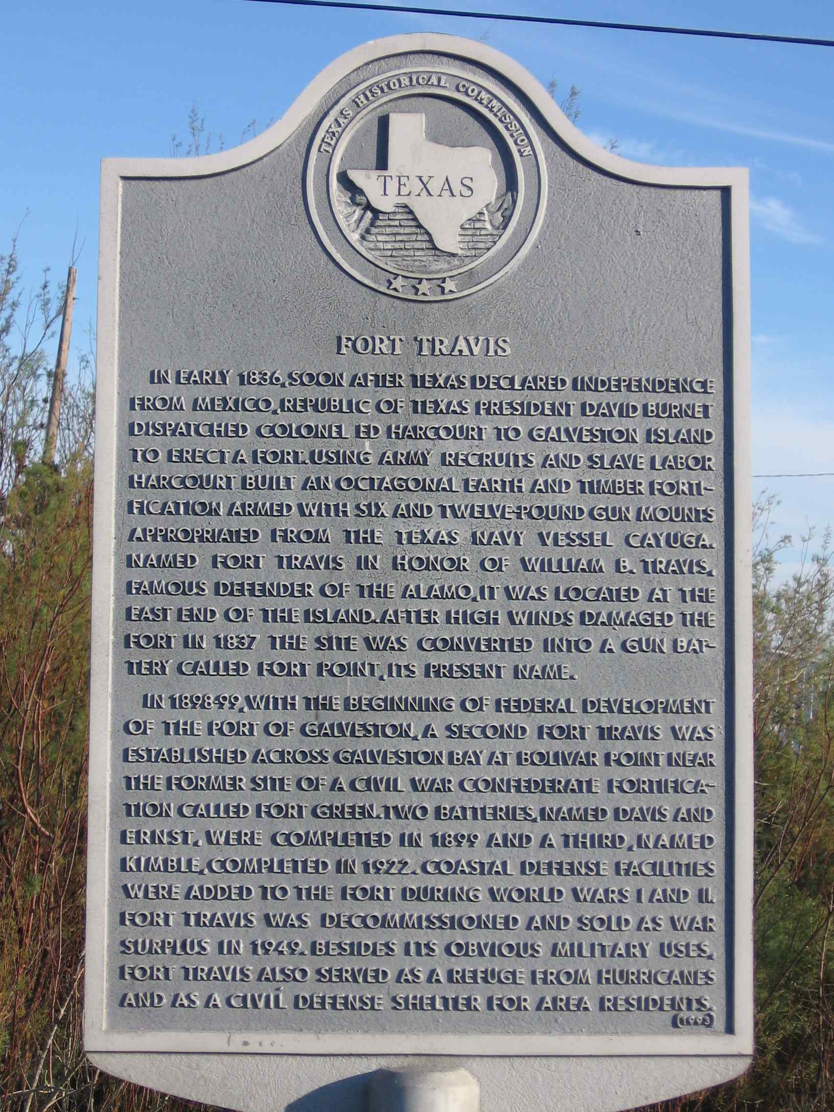
Fort Travis in Bolivar Peninsula, separate from the Fort Travis in Galveston Island, was built with construction started in 1898. The fort had its own railroad spur.[7]
The 1915 Galveston hurricane damaged Port Bolivar, and its port was mostly not rebuilt.[8]
Until the Second World War, Santa Fe subsidiary Gulf, Colorado & Santa Fe Railway served Port Bolivar and provided a ferry service to Galveston for railcars. The trackage was cut back to High Island in 1942 and the rails on the Bolivar Peninsula scrapped for the war effort.
After Hurricane Ike the United States Postal Service temporarily relocated Port Bolivar post office box services to Winnie, Texas.[9]
Transportation
Ferry service is provided by the Texas Department of Transportation between Port Bolivar and Galveston. The Galveston-Port Bolivar ferry[10] can accommodate vehicles as heavy as 80,000 pounds, and as long as 65 feet, as high as 13.5 feet and as wide as 8.5 feet.[11] The ferry was closed because of Hurricane Ike[1] but re-opened on November 11, 2008.[12]
Education
Port Bolivar residents are zoned to Galveston Independent School District schools.[13][14]
Residents attend Crenshaw Elementary and Middle School for grades Pre-K3 through 8 on the peninsula. Residents attend Ball High School in Galveston.[15]
The current Crenshaw building, in Crystal Beach,[16] opened in 2005.[17] The former Crenshaw campus was in Port Bolivar.[13]
Galveston College also serves Bolivar Peninsula.
Parks and recreation
The Galveston County Department of Parks & Cultural Services, that includes Senior Services, operates the Bolivar Community Center, 1802 Madison Avenue, the Fort Travis Seashore Park at 900 State Highway 87, and the Pilsner Boat Ramp.[18]
Postal service
The United States Postal Service operates the Post Office at 2500 Broadway Avenue, Port Bolivar, TX 77650 - 0736.[19] There is no home delivery on the Bolivar peninsula, only rural delivery.
References
- ^ a b Zucchino, David (September 16, 2008). "A bird's-eye view of Hurricane Ike's handiwork along Texas coast". LA Times. Los Angeles, CA. Retrieved December 27, 2015.
- ^ Rice, Harvey (February 16, 2013). "Ike changed Bolivar Peninsula forever".
- ^ "Port Bolivar (zip 77650), Texas". Sperling's Best Places. Sperling's BestPlaces. 2015. Retrieved December 27, 2015.
- ^ "Port Bolivar, TX 77650 ZIP Code Profile". TX HomeTownLocator. HTL Inc. 2015. Retrieved December 27, 2015.
- ^ "77650 Zip Code Detailed Profile". City-Data. Onboard Informatics. 2015. Retrieved December 27, 2015.
- ^ a b c d A. Pat Daniels. "PORT BOLIVAR, TX". Handbook of Texas Online. Texas State Historical Association. Retrieved 2013-06-11.
- ^ "Fort Travis". Texas Historical Commission. Retrieved 2013-06-11.
- ^ "Port Bolivar". Galveston County Historical Museum. Retrieved 2013-06-11.
- ^ "Postal Service Relocates Services, Deploys Portable Buildings." United States Postal Service. September 18, 2008. Retrieved on April 7, 2009.
- ^ "Galveston-Bolivar Ferry Information". Houston TranStar. Houston TranStar. 2015. Retrieved December 27, 2015.
- ^ "Ferry Information". Ferry Information. Texas Department of Transportation. 2015. Retrieved December 27, 2015.
- ^ Paschenko, Chris. "Rebuilding peninsula a long, arduous process." Galveston County Daily News. November 27, 2008.
- ^ a b "schools." Galveston Independent School District. April 22, 2001. Retrieved on January 5, 2015. "Bolivar School Madison Avenue Pt. Bolivar, TX "
- ^ "SCHOOL DISTRICT REFERENCE MAP (2010 CENSUS): Galveston County, TX." U.S. Census Bureau. Retrieved on January 4, 2015.
- ^ "attendance zones" (Archive). Galveston Independent School District. January 5, 2015. "GISD students residing on the Bolivar Peninsula attend Bolivar School for grades K-8 and Ball High School for grades 9-12."
- ^ Thompson, Carter. "Board sets aside money for work on new school" (Archive). The Galveston County Daily News. February 27, 2003. Retrieved on January 5, 2015. "District staff also has settled on a site — a piece of land in Crystal Beach that the owner has offered to donate to the district."
- ^ "Crenshaw School Profile." Galveston Independent School District. Retrieved on November 30, 2008.
- ^ Galveston County Department of Parks & Cultural Services. Retrieved on July 12, 2019.
- ^ "Post office locations in Galveston County, TX". Post Office Finder. PostOfficeFinder.org. 2015. Retrieved December 27, 2015.
Places adjacent to Port Bolivar, Texas | ||||||||||||||||
|---|---|---|---|---|---|---|---|---|---|---|---|---|---|---|---|---|
| ||||||||||||||||
Municipalities and communities of Galveston County, Texas, United States | ||
|---|---|---|
| Cities |  | |
| Village | ||
| CDPs | ||
| Other communities | ||
| Footnotes | ‡This populated place also has portions in an adjacent county or counties | |