
File:Zellerrain.jpg

Size of this preview: 800 × 533 pixels. Other resolutions: 320 × 213 pixels | 640 × 427 pixels | 1,024 × 683 pixels | 1,280 × 853 pixels | 1,536 × 1,024 pixels.
Original file (1,536 × 1,024 pixels, file size: 1.26 MB, MIME type: image/jpeg)
| This is a file from the Wikimedia Commons. Information from its description page there is shown below. Commons is a freely licensed media file repository. You can help. |
Summary
| Description |
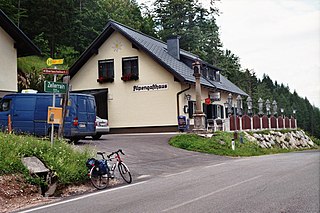
English: On the Zellerrain pass between Styria and Lower Austria near Mariazell with inn and the Kartäusersäule column.
Deutsch: Passhöhe Zellerrain |
| Date | |
| Source | Own work |
| Author | Haneburger |
| Camera location | | View this and other nearby images on: OpenStreetMap |
|---|
Licensing
| I, the copyright holder of this work, release this work into the public domain. This applies worldwide. In some countries this may not be legally possible; if so: I grant anyone the right to use this work for any purpose, without any conditions, unless such conditions are required by law. |
File history
Click on a date/time to view the file as it appeared at that time.
| Date/Time | Thumbnail | Dimensions | User | Comment | |
|---|---|---|---|---|---|
| current | 05:50, 17 February 2009 | | 1,536 × 1,024 (1.26 MB) | Haneburger | {{Information |Description=={{en|1=On the Zellerrain between Styria and Lower Austria near Mariazell}} {{de|1=Passhöhe Zellerrain}} |Source=eigene Arbeit |Date=2008-07-04 |Author= Haneburger |Permission= |other_versions= }} [[Catego |
File usage
The following pages on the English Wikipedia use this file (pages on other projects are not listed):
Global file usage
The following other wikis use this file:
- Usage on ceb.wikipedia.org
- Usage on de.wikipedia.org
- Usage on uk.wikipedia.org
- Usage on www.wikidata.org