
File:Zanj Rebellion.svg

Size of this PNG preview of this SVG file: 750 × 600 pixels. Other resolutions: 300 × 240 pixels | 600 × 480 pixels | 960 × 768 pixels | 1,280 × 1,024 pixels | 2,560 × 2,048 pixels | 900 × 720 pixels.
Original file (SVG file, nominally 900 × 720 pixels, file size: 1.2 MB)
| This is a file from the Wikimedia Commons. Information from its description page there is shown below. Commons is a freely licensed media file repository. You can help. |
Summary
| Description |
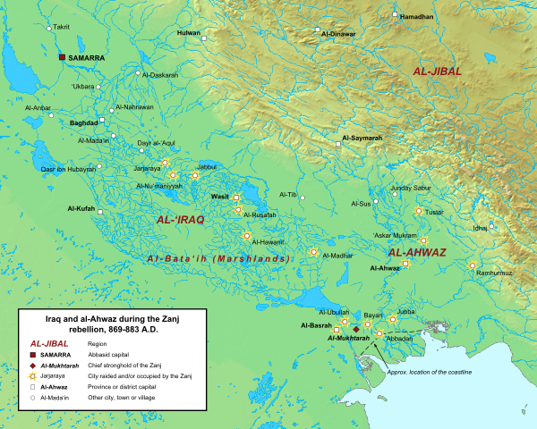
English: Map of the central Abbasid caliphate during the rebellion of the Zanj, from 869 to 883 A.D. All settlements on this map are listed by al-Tabari in his History of the Prophets and Kings, trans. "The History of al-Tabari," volumes 35 through 37. The location of cities and towns that no longer exist were determined using the maps of Le Strange and Popovic in their respective works.
Background topography taken from DEMIS Mapserver, which are public domain. Works Cited:
|
| Date | |
| Source | Own work |
| Author | Ro4444 |
Licensing
I, the copyright holder of this work, hereby publish it under the following license:
This file is licensed under the Creative Commons Attribution-Share Alike 3.0 Unported license.
- You are free:
- to share – to copy, distribute and transmit the work
- to remix – to adapt the work
- Under the following conditions:
- attribution – You must give appropriate credit, provide a link to the license, and indicate if changes were made. You may do so in any reasonable manner, but not in any way that suggests the licensor endorses you or your use.
- share alike – If you remix, transform, or build upon the material, you must distribute your contributions under the same or compatible license as the original.
File history
Click on a date/time to view the file as it appeared at that time.
| Date/Time | Thumbnail | Dimensions | User | Comment | |
|---|---|---|---|---|---|
| current | 14:42, 16 June 2015 | | 900 × 720 (1.2 MB) | Ro4444 | Changing location of al-Madhar to 31° 28' 23.4726" N, 47° 23' 4.4982", the location of the burial place of 'Abdallah ibn 'Ali ibn Abi Talib. See M. Streck, "Maisan," ''E.J. Brill's First Encyclopaedia of Islam, Volume V,'' (Leiden: E.J. Brill, 1927),... |
| 21:13, 3 March 2013 |  | 900 × 720 (1.2 MB) | Ro4444 | User created page with UploadWizard |
File usage
The following pages on the English Wikipedia use this file (pages on other projects are not listed):
Global file usage
The following other wikis use this file:
- Usage on ar.wikipedia.org
- Usage on arz.wikipedia.org
- Usage on azb.wikipedia.org
- Usage on ca.wikipedia.org
- Usage on cy.wikipedia.org
- Usage on de.wikipedia.org
- Usage on es.wikipedia.org
- Usage on fa.wikipedia.org
- Usage on fr.wikipedia.org
- Usage on ga.wikipedia.org
- Usage on he.wikipedia.org
- Usage on id.wikipedia.org
- Usage on ms.wikipedia.org
- Usage on pt.wikipedia.org
- Usage on sv.wikipedia.org
- Usage on tr.wikipedia.org
- Usage on www.wikidata.org
- Usage on zh.wikipedia.org