
File:Yom Kippur War map.svg

Size of this PNG preview of this SVG file: 398 × 599 pixels. Other resolutions: 159 × 240 pixels | 319 × 480 pixels | 510 × 768 pixels | 680 × 1,024 pixels | 1,361 × 2,048 pixels | 400 × 602 pixels.
Original file (SVG file, nominally 400 × 602 pixels, file size: 43 KB)
| This is a file from the Wikimedia Commons. Information from its description page there is shown below. Commons is a freely licensed media file repository. You can help. |
Summary
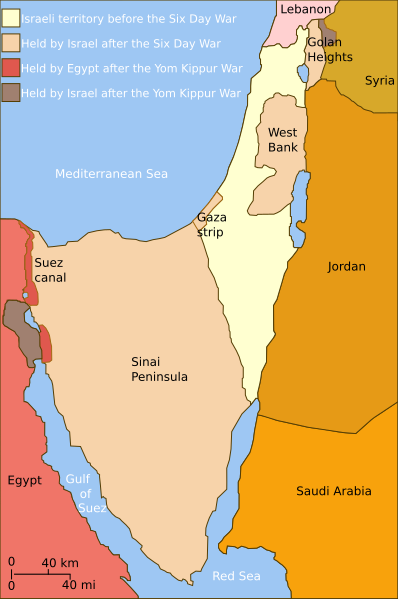
| Description | Self-made line drawing of a map of Israel's territories before and after the Yom Kippur War. |
| Date | |
| Source | Source of line drawing: Now-deleted image Jom kippur war.jpg which was originally uploaded to the polish Wikipedia at Jom kippur war.jpg -- Ministerstwo Spraw Zagranicznych Izraela, za zgodÄ… Ambasady Izraela w Polsce. -- Ministry of Foreign Affairs of Israel, with the permission of Israel Embassy in Poland |
| Author | Raul654 |
| Other versions |
[]
|
| SVG development |


|
This SVG file contains embedded text that can be translated into your language, using any capable SVG editor, text editor or the SVG Translate tool. For more information see: About translating SVG files. |
Licensing
This file is licensed under the Creative Commons Attribution-Share Alike 2.5 Generic license.
- You are free:
- to share – to copy, distribute and transmit the work
- to remix – to adapt the work
- Under the following conditions:
- attribution – You must give appropriate credit, provide a link to the license, and indicate if changes were made. You may do so in any reasonable manner, but not in any way that suggests the licensor endorses you or your use.
- share alike – If you remix, transform, or build upon the material, you must distribute your contributions under the same or compatible license as the original.
File history
Click on a date/time to view the file as it appeared at that time.
| Date/Time | Thumbnail | Dimensions | User | Comment | |
|---|---|---|---|---|---|
| current | 14:35, 3 July 2010 | | 400 × 602 (43 KB) | ChrisO | |
| 12:52, 20 February 2010 |  | 400 × 602 (43 KB) | Hohum | Added border lines. | |
| 13:42, 31 May 2009 |  | 400 × 602 (46 KB) | Hohum | Fixed Golan Heights colour. | |
| 13:39, 31 May 2009 |  | 400 × 602 (46 KB) | Hohum | Adjusted colours to be less garish, more map-like. | |
| 11:32, 9 April 2009 |  | 400 × 602 (45 KB) | Kordas | colours fixed | |
| 23:23, 15 May 2008 |  | 400 × 602 (46 KB) | Kordas | Updated version (Added "West Bank" and seas names' in white) | |
| 04:11, 3 October 2007 |  | 400 × 602 (46 KB) | Andrew Hampe | Removed line referencing external jpeg image. | |
| 03:58, 3 October 2007 |  | 400 × 602 (45 KB) | Raul654 | Standard svg | |
| 03:55, 3 October 2007 |  | 400 × 602 (45 KB) | Raul654 | Self-made line drawing of a map of Israel's territories before and after the Yom Kippur War. Source of line drawing: Now-deleted image Image:Jom kippur war.jpg {{cc-by-sa}} |
File usage
The following pages on the English Wikipedia use this file (pages on other projects are not listed):
Global file usage
The following other wikis use this file:
- Usage on ar.wikipedia.org
- Usage on ca.wikipedia.org
- Usage on ckb.wikipedia.org
- Usage on fa.wikipedia.org
- Usage on fr.wikipedia.org
- Usage on fr.wikiversity.org
- Usage on he.wikipedia.org
- Usage on hy.wikipedia.org
- Usage on id.wikipedia.org
- Usage on it.wikipedia.org
- Usage on ja.wikipedia.org
- Usage on jv.wikipedia.org
- Usage on mzn.wikipedia.org
- Usage on no.wikipedia.org
- Usage on pt.wikipedia.org
- Usage on ro.wikipedia.org
- Usage on sh.wikipedia.org
- Usage on tg.wikipedia.org
- Usage on www.wikidata.org
- Usage on zh.wikipedia.org