
File:Yemen division 2012-3-11.svg

Size of this PNG preview of this SVG file: 800 × 522 pixels. Other resolutions: 320 × 209 pixels | 640 × 418 pixels | 1,024 × 668 pixels | 1,280 × 835 pixels | 2,560 × 1,670 pixels.
Original file (SVG file, nominally 1,280 × 835 pixels, file size: 1.26 MB)
| This is a file from the Wikimedia Commons. Information from its description page there is shown below. Commons is a freely licensed media file repository. You can help. |
Summary
| Description |
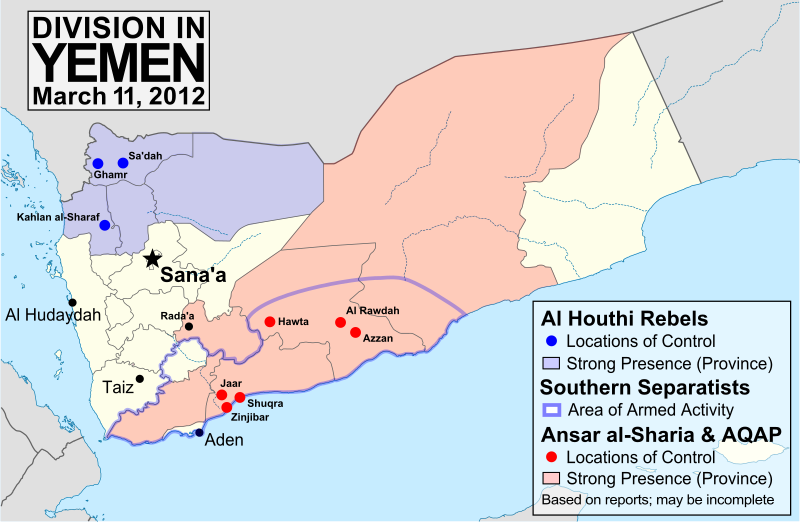
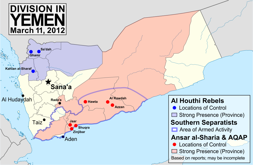
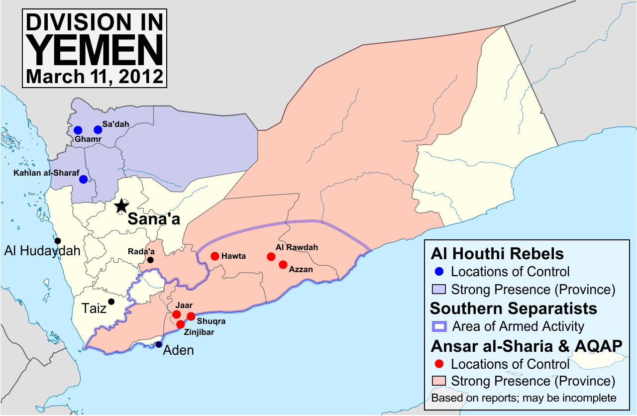
English: Map of division in Yemen as of March 10, 2012 (after the transition of power away from President Saleh). Map is limited to information from English-language media, and therefore may be incomplete. The Al Houthis are a Zaidi Shiite rebel group, while Ansar al-Sharia and Al Qaeda in the Arabian Peninsula (AQAP) are two related violent Islamic fundamentalist groups. Note that unarmed protests are not depicted, and would extend well into the white areas of the map. See also: File:Yemen division 2011-7-7.svg, File:Yemen division 2011-10-23.svg |
| Date | |
| Source | Own work, starting from File:Yemen_location_map.svg by user NordNordWest. Information comes from a variety of online news sources, especially the Yemen Post and Critical Threats. |
| Author | GeoEvan |
| Permission (Reusing this file) |
Modified version of file from Political Geography Now, re-licensed here to allow for commercial use. Any usage of this map must credit "Political Geography Now", with a hyperlink to www.polgeonow.com if possible (offline media reproductions must print the URL). |
| Other versions |
Derivative works of this file: Yemen division 2012-3-11-tr.svg Derivative works of this file: Yemen division (ar) 2012-3-11.JPG |
_2012-3-11.JPG)
Licensing
I, the copyright holder of this work, hereby publish it under the following license:
This file is licensed under the Creative Commons Attribution-Share Alike 3.0 Unported license.
- You are free:
- to share – to copy, distribute and transmit the work
- to remix – to adapt the work
- Under the following conditions:
- attribution – You must give appropriate credit, provide a link to the license, and indicate if changes were made. You may do so in any reasonable manner, but not in any way that suggests the licensor endorses you or your use.
- share alike – If you remix, transform, or build upon the material, you must distribute your contributions under the same or compatible license as the original.
File history
Click on a date/time to view the file as it appeared at that time.
| Date/Time | Thumbnail | Dimensions | User | Comment | |
|---|---|---|---|---|---|
| current | 19:04, 23 March 2012 | | 1,280 × 835 (1.26 MB) | GeoEvan | =={{int:filedesc}}== {{Information |description={{en|1=Map of division in Yemen as of March 10, 2012 (after the transition of power away from President Saleh). Map is limited to information from English-language media, and therefore may be incomplete. ... |
File usage
The following pages on the English Wikipedia use this file (pages on other projects are not listed):
Global file usage
The following other wikis use this file:
- Usage on ar.wikipedia.org
- Usage on azb.wikipedia.org
- Usage on ca.wikipedia.org
- Usage on es.wikivoyage.org
- Usage on fa.wikipedia.org
- Usage on ja.wikipedia.org
- Usage on pl.wikivoyage.org
- Usage on pt.wikipedia.org
- Usage on ru.wikipedia.org
- Usage on uk.wikipedia.org
- Usage on www.wikidata.org