
File:World map of bathymetric data - GEBCO 2014.jpg

Size of this preview: 800 × 439 pixels. Other resolutions: 320 × 176 pixels | 640 × 351 pixels | 1,024 × 562 pixels | 1,280 × 702 pixels | 2,000 × 1,097 pixels.
Original file (2,000 × 1,097 pixels, file size: 510 KB, MIME type: image/jpeg)
| This is a file from the Wikimedia Commons. Information from its description page there is shown below. Commons is a freely licensed media file repository. You can help. |
Summary
| Description |
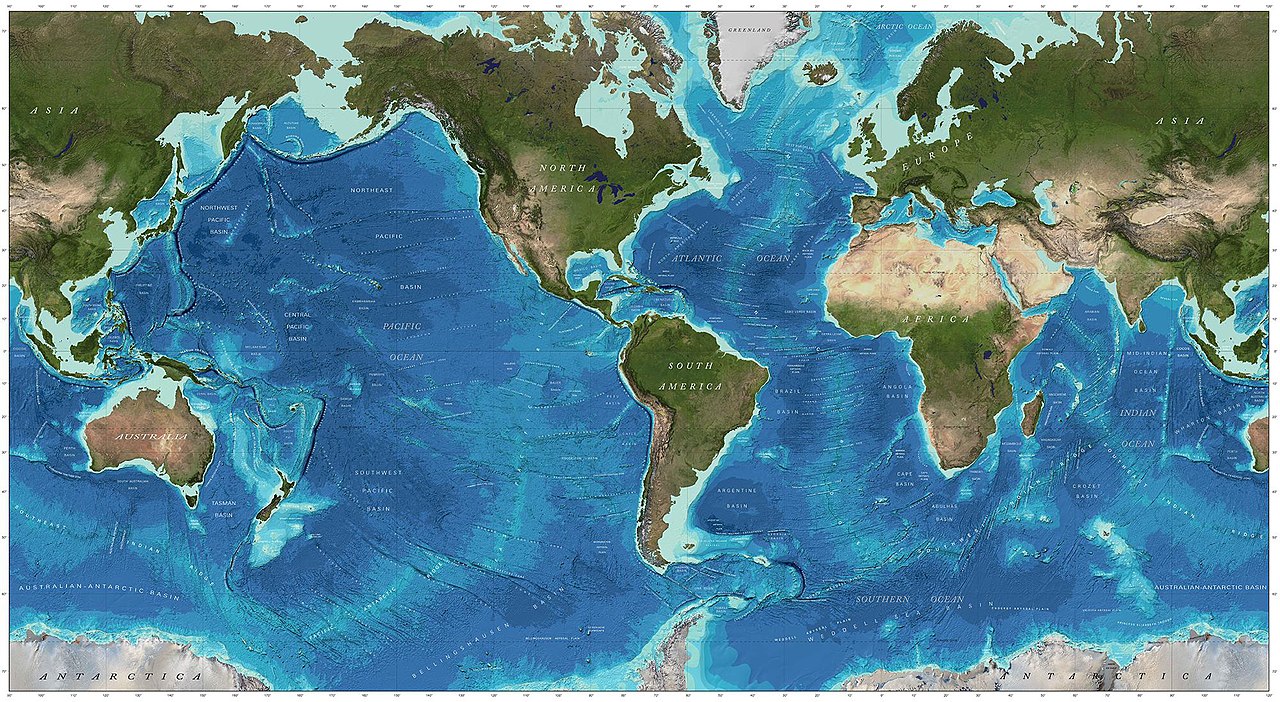
English: World map of bathymetric data - GEBCO 2014 |
| Date | |
| Source | [1] doi:10.3389/fmars.2019.00241 |
| Author | GEBCO world map 2014 (public domain) |
Licensing
| This file is made available under the Creative Commons CC0 1.0 Universal Public Domain Dedication. | |
| The person who associated a work with this deed has dedicated the work to the public domain by waiving all of their rights to the work worldwide under copyright law, including all related and neighboring rights, to the extent allowed by law. You can copy, modify, distribute and perform the work, even for commercial purposes, all without asking permission.
|
File history
Click on a date/time to view the file as it appeared at that time.
| Date/Time | Thumbnail | Dimensions | User | Comment | |
|---|---|---|---|---|---|
| current | 18:18, 31 October 2020 | | 2,000 × 1,097 (510 KB) | Epipelagic | Uploaded a work by [https://www.gebco.net/data_and_products/gridded_bathymetry_data/ GEBCO world map 2014] (public domain) from [https://www.frontiersin.org/articles/10.3389/fmars.2019.00241/full] {{doi|10.3389/fmars.2019.00241}} with UploadWizard |
File usage
The following pages on the English Wikipedia use this file (pages on other projects are not listed):
Global file usage
The following other wikis use this file:
- Usage on es.wikipedia.org
- Usage on fr.wikipedia.org
- Usage on id.wikipedia.org
- Usage on it.wikibooks.org
- Usage on it.wikiversity.org
- Usage on lt.wikipedia.org
- Usage on mk.wikipedia.org
- Usage on simple.wikipedia.org
- Usage on tr.wikipedia.org
- Usage on www.wikidata.org
- Usage on zh.wikipedia.org