
File:Wilderness road de.png

Size of this preview: 800 × 508 pixels. Other resolutions: 320 × 203 pixels | 640 × 406 pixels | 1,024 × 650 pixels | 1,254 × 796 pixels.
Original file (1,254 × 796 pixels, file size: 1.74 MB, MIME type: image/png)
| This is a file from the Wikimedia Commons. Information from its description page there is shown below. Commons is a freely licensed media file repository. You can help. |
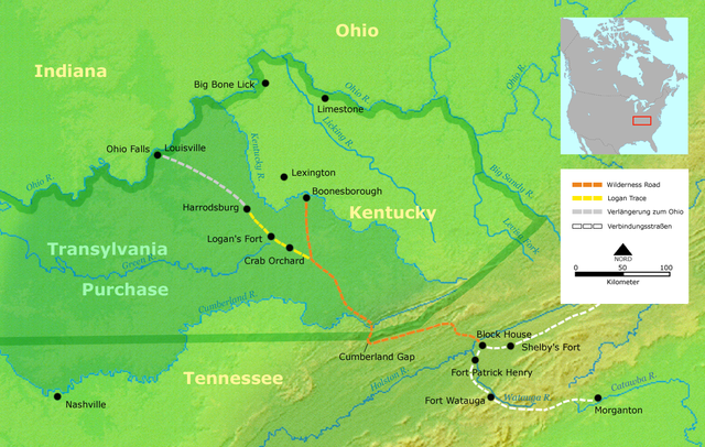
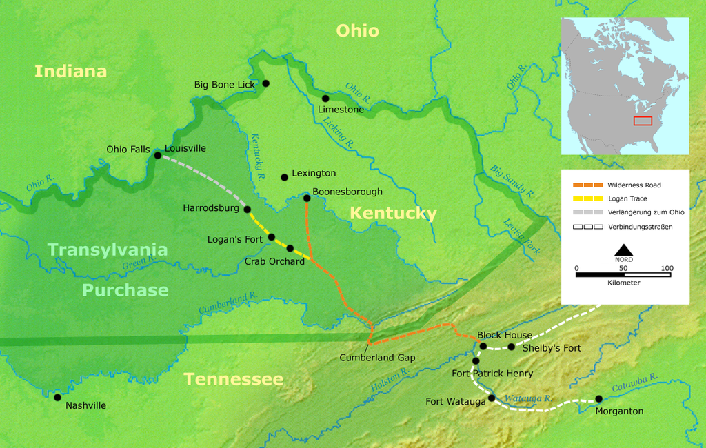
- Description: Course of the Wilderness Road in Kentucky by 1785
- Source: Own work by Nikater, submitted to the public domain. Background map courtesy of Demis, www.demis.nl.
- Uploader: User:Nikater
- Date: 16 Mar 2007
- Other Versions: English Image:Wilderness road_en.png
- License status:
This image is in the public domain because it came from the site https://www.demis.nl/products/web-map-server/examples/ and was released by the copyright holder. Permission is granted to copy, distribute and/or modify this map since it is based on free of copyright images from: www.demis.nl. See also approval email on de.wp and its clarification.
|
| This work has been released into the public domain by its copyright holder, www.demis.nl. This applies worldwide. In some countries this may not be legally possible; if so: www.demis.nl grants anyone the right to use this work for any purpose, without any conditions, unless such conditions are required by law.
|

|
This map image could be re-created using vector graphics as an SVG file. This has several advantages; see Commons:Media for cleanup for more information. If an SVG form of this image is available, please upload it and afterwards replace this template with
{{vector version available|new image name}}.
It is recommended to name the SVG file “Wilderness road de.svg”—then the template Vector version available (or Vva) does not need the new image name parameter. |
File history
Click on a date/time to view the file as it appeared at that time.
| Date/Time | Thumbnail | Dimensions | User | Comment | |
|---|---|---|---|---|---|
| current | 13:26, 21 March 2007 | | 1,254 × 796 (1.74 MB) | Nikater | * Description: Course of the Wilderness Road in Kentucky by 1785 * Source: Own work by Nikater, submitted to the public domain. Background map courtesy of Demis, www.demis.nl. * Uploader: User:Nikater * Date: 21 Mar 2007 * Other Versions: English: Ima |
| 08:44, 17 March 2007 |  | 1,255 × 760 (1.64 MB) | Nikater | * Description: Course of the Wilderness Road in Kentucky by 1785 * Source: Own work by Nikater, submitted to the public domain. Background map courtesy of Demis, www.demis.nl. * Uploader: User:Nikater * Date: 17 Mar 2007 * Other Versions: English [[im | |
| 17:37, 16 March 2007 |  | 1,255 × 760 (1.64 MB) | Nikater | * Description: Course of the Wilderness Road in Kentucky by 1785 * Source: Own work by Nikater, submitted to the public domain. Background map courtesy of Demis, www.demis.nl. * Uploader: User:Nikater * Date: 16 Mar 2007 * Other Versions: English [[im | |
| 13:29, 16 March 2007 |  | 1,255 × 760 (1.64 MB) | Nikater | * Description: Course of the Wilderness Road in Kentucky by 1785 * Source: Own work by Nikater, submitted to the public domain. Background map courtesy of Demis, www.demis.nl. * Uploader: User:Nikater * Date: 16 Mar 2007 * Other Versions: English [[im |
File usage
The following pages on the English Wikipedia use this file (pages on other projects are not listed):
Global file usage
The following other wikis use this file:
- Usage on de.wikipedia.org