
File:Wikiarabiaboundaries.jpg

Size of this preview: 800 × 433 pixels. Other resolutions: 320 × 173 pixels | 640 × 346 pixels | 1,024 × 554 pixels | 1,280 × 693 pixels | 1,900 × 1,028 pixels.
Original file (1,900 × 1,028 pixels, file size: 919 KB, MIME type: image/jpeg)
| This is a file from the Wikimedia Commons. Information from its description page there is shown below. Commons is a freely licensed media file repository. You can help. |
Summary
| Description |
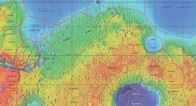
English: MOLA map showing boundaries of Arabia and nearby regions |
| Date | |
| Source | http://planetarynames.wr.usgs.gov/images/mola_regional_boundaries.pdf |
| Author | Jim Secosky modified NASA image. |
| Permission (Reusing this file) |
Caption is International Astronomical Union Working Group for Planetary System Nomenclature. "Gazetteer of Planetary Nomenclature." |
Licensing
| This file is in the public domain in the United States because it was solely created by NASA. NASA copyright policy states that "NASA material is not protected by copyright unless noted". (See Template:PD-USGov, NASA copyright policy page or JPL Image Use Policy.) | ||
 |
Warnings:
|
File history
Click on a date/time to view the file as it appeared at that time.
| Date/Time | Thumbnail | Dimensions | User | Comment | |
|---|---|---|---|---|---|
| current | 22:28, 17 February 2019 | | 1,900 × 1,028 (919 KB) | Dogman15 | Removed web browser view (Firefox) and taskbar view (Microsoft Windows) by going back to the source and re-capturing a new screenshot. |
| 00:03, 20 February 2015 |  | 1,920 × 1,080 (873 KB) | Jimmarsmars | {{Information |Description ={{en|1=MOLA map showing boundaries of Arabia and nearby regions}} |Source =http://planetarynames.wr.usgs.gov/images/mola_regional_boundaries.pdf |Author =Jim Secosky modified NASA image. |Date =2... |
File usage
The following pages on the English Wikipedia use this file (pages on other projects are not listed):
Global file usage
The following other wikis use this file:
- Usage on ar.wikipedia.org
- Usage on ca.wikipedia.org
- Usage on de.wikipedia.org
- Usage on es.wikipedia.org
- Usage on hu.wikipedia.org
- Usage on lb.wikipedia.org
- Usage on vi.wikipedia.org
- Usage on zh.wikipedia.org