
File:Westray to Papa Westray air route map.png

Original file (667 × 856 pixels, file size: 192 KB, MIME type: image/png)
| This is a file from the Wikimedia Commons. Information from its description page there is shown below. Commons is a freely licensed media file repository. You can help. |
Summary
| Description |
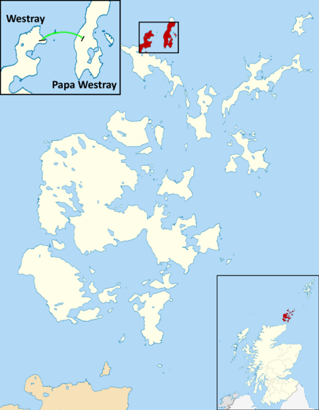
English: This is a map depicting the shortest scheduled airline flight in the world as of December, 2016. The record was established in 1967. The flight goes between two islands in Orkney, Scotland: Westray and Papa Westray. |
| Date | |
| Source | Own work |
| Author | Dcs002 |
I believe I am the copyright holder because I used a Wikimedia Commons image (File:Orkney_Islands_UK_blank_map.svg) and substantially altered it myself. I release the work I have added to it under the license above. The image I began with is posted under the "Creative Commons Attribution-Share Alike 3.0 Unported license", which is why I selected that license. I am not experienced enough in these matters to select the correct license based on the work I altered. I do not care to retain any rights for myself. I just want this image (or a similar image) for the Wikipedia article about the flight. Please help if I have done this incorrectly.
Licensing
- You are free:
- to share – to copy, distribute and transmit the work
- to remix – to adapt the work
- Under the following conditions:
- attribution – You must give appropriate credit, provide a link to the license, and indicate if changes were made. You may do so in any reasonable manner, but not in any way that suggests the licensor endorses you or your use.
- share alike – If you remix, transform, or build upon the material, you must distribute your contributions under the same or compatible license as the original.
File history
Click on a date/time to view the file as it appeared at that time.
| Date/Time | Thumbnail | Dimensions | User | Comment | |
|---|---|---|---|---|---|
| current | 20:17, 18 April 2017 | | 667 × 856 (192 KB) | Maproom | Adjusted map to show the Loch of St. Tredwell as a freshwater loch, not a sea loch. |
| 01:56, 21 December 2016 |  | 667 × 856 (284 KB) | Dcs002 | User created page with UploadWizard |
File usage
Global file usage
The following other wikis use this file:
- Usage on hu.wikipedia.org
- Usage on vi.wikipedia.org
- Usage on zh.wikipedia.org